Related Research Articles

Tucson is a city in and the county seat of Pima County, Arizona, United States, and is home to the University of Arizona. It is the second-largest city in Arizona behind Phoenix, with a population of 542,629 in the 2020 United States census, while the population of the entire Tucson metropolitan statistical area (MSA) is 1,043,433. The Tucson MSA forms part of the larger Tucson-Nogales combined statistical area. Both Tucson and Phoenix anchor the Arizona Sun Corridor. The city is 108 miles (174 km) southeast of Phoenix and 60 mi (97 km) north of the United States–Mexico border. Tucson is the 34th-largest city and the 53rd-largest metropolitan area in the United States (2014).

Buckeye is a city in Maricopa County, Arizona, United States. It is Arizona's largest city by area, and it is the westernmost suburb in the Phoenix Metropolitan Area. As of the 2020 census, the population was 91,502, up from 50,876 in 2010, and 6,537 in 2000. It was the fastest-growing city in the United States for 2017, 2018, and 2021.

Casas Adobes is an unincorporated community and census-designated place (CDP) located in the northern metropolitan area of Tucson, Arizona. The population was 66,795 at the 2010 census. Casas Adobes is situated south and southwest of the town of Oro Valley, and west of the community of Catalina Foothills.

Catalina Foothills is an unincorporated community and census-designated place (CDP) located north of Tucson in Pima County, Arizona, United States. Situated in the southern foothills of the Santa Catalina Mountains, Catalina Foothills had a population of 50,796 at the 2010 census. Catalina Foothills is one of the most affluent communities in Arizona and in the U.S., with the 6th highest per capita income in Arizona, and the 14th highest per capita income in the U.S. of communities with a population of at least 50,000. The Catalina Foothills community includes some of Arizona's most expensive homes and land, and has the highest median property value. It also includes resorts, golf courses, and spas.

Marana is a town in Pima County, Arizona, United States, located northwest of Tucson, with a small portion in Pinal County. According to the 2021 Census, the population of the town was 54,895. From 1990 to 2000, Marana was the fourth fastest-growing place among all cities and towns of any size in Arizona.

Oro Valley, incorporated in 1974, is a suburban town located 6 miles (9.7 km) north of Tucson, Arizona, United States, in Pima County. According to the 2020 census, the population of the town is 47,070, an increase from 29,700 in 2000. Dubbed the "Upscale Tech Mecca" of Southern Arizona by the Arizona Daily Star newspaper, Oro Valley is home to over 10 high tech firms and has a median household income nearly 50% higher than the U.S. median. The town is located approximately 110 miles (180 km) southeast of the state capital of Phoenix.
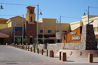
Sahuarita is a town in Pima County, Arizona, United States. Sahuarita is located south of the Tohono O'odham Nation and abuts the north end of Green Valley, 15 miles (24 km) south of Tucson. The population was 34,134 at the 2020 census.

Vail is a census-designated place (CDP) in Pima County, Arizona, United States. It is 24 miles (39 km) southeast of Tucson. The population was 10,208 at the 2010 census, up from 2484 in the 2000 census. The area is known for the nearby Colossal Cave, a large cave system, and the Rincon Mountains District of Saguaro National Park, a top tourism spot within Arizona.

Oracle is a census-designated place (CDP) in Pinal County, Arizona, United States. The population was 3,686 at the 2010 Census, falling to 3,051 at the 2020 Census.

The Rincon Mountains are a significant mountain range east of Tucson, Pima County, Arizona, in the United States. The Rincon Mountains are one of five mountain ranges surrounding the Tucson valley. The other ranges include the most prominent, the Santa Catalina Mountains to the north, the Santa Rita Mountains to the south, the Tucson Mountains to the west, and the Tortolita Mountains to the northwest. Redington Pass separates the Rincon Mountains from the Santa Catalina Mountains. The Rincon Mountains are generally less rugged than the Santa Catalina Mountains and Santa Rita Mountains. The Rincon Mountains are also included in the Madrean sky island mountain ranges of southeast Arizona, extreme southwest New Mexico, and northern Sonora Mexico.

The Southern Arizona Transportation Museum is a railroad museum in Tucson, Arizona. It is located in the former records vault building at the former Southern Pacific Depot, which was renovated by the City of Tucson in 2004.

Phoenix Union Station is a former train station at 401 South 4th Avenue in downtown Phoenix, Arizona, United States. From 1971 to 1996 it was an Amtrak station. Until 1971, it was a railroad stop for the Santa Fe and Southern Pacific Railroads. Union Station was served by Amtrak's Los Angeles–New Orleans Sunset Limited and Los Angeles–Chicago Texas Eagle. The station is on the National Register of Historic Places.
Tres Alamos is a ghost town in Cochise County in the U.S. state of Arizona. The town was settled in 1874 in what was then the Arizona Territory.

In the U.S. state of Arizona, Interstate 10 (I‑10), the major east–west Interstate Highway in the United States Sun Belt, runs east from California, enters Arizona near the town of Ehrenberg and continues through Phoenix and Tucson and exits at the border with New Mexico near San Simon. The highway also runs through the cities of Casa Grande, Eloy, and Marana. Segments of the highway are referred to as either the Papago Freeway, Inner Loop, or Maricopa Freeway within the Phoenix area and the Pearl Harbor Memorial Highway outside metro Phoenix.

Tucson station is an Amtrak train depot in Tucson, Arizona, served three times a week by the Sunset Limited and Texas Eagle trains.
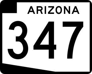
State Route 347, also known as John Wayne Parkway, is a 28.69 miles (46.17 km) long, north–south state highway in central Arizona. The route begins at SR 84 and heads north. It passes through Maricopa, meeting SR 238. The route ends at an interchange with Interstate 10 (I-10) south of Chandler. It primarily serves as the major road to Maricopa; much of the road lies within the Gila River Indian Community, with another short stretch through the Ak-Chin Indian Community. The road was built in the late 1930s and established as a state highway in the 1990s. On average, between 4,000 and 35,000 vehicles use the roadway daily.

Colossal Cave is a large cave system in southeastern Arizona, United States, near the community of Vail, about 22 miles (35 km) southeast of Tucson. It contains about 3.5 miles (5.6 km) of mapped passageways. Temperatures inside average 70 °F (21 °C) year-round. Previous names include 'Mountain Springs Cave' and 'Five–Mile Cave'.

Pantano is a ghost town located in eastern Pima County, Arizona, between Benson and Vail. Access is via the Marsh Station Road interchange on I-10. It was originally a mail and stagecoach stop named Ciénega Station, after the nearby Ciénega Creek, and later grew into a small railroad town with the arrival of the Southern Pacific in 1880.

The Esmond Train Wreck on January 28, 1903, 3:30 am, about 9 miles (14 km) east of present-day Tucson, Arizona, killed 14 people, including the engineers of both trains. The accident occurred when the eastbound Crescent City Express collided head-on with the westbound Pacific Coast Express. Both trains were running late. A communication error was determined to be the cause of the wreck. A night operator named Clough admitted that he did not deliver a second order to Conductor Parker which instructed him to pull the Crescent City Express, headed for New Orleans, on to the Esmond siding to allow the Pacific Coast Express, headed for San Francisco, to pass by.
The Loop is a network of shared-use paths in metropolitan Tucson, Arizona maintained by Pima County. Once complete it will comprise 131 miles (211 km) of paved trails dedicated to cyclist, pedestrian, and equestrian use. By 2014, the network was 85% complete, with over one hundred miles in place. Pima County estimates the Loop is used by an average of 2,000 visitors each weekday and more than 5,000 on weekends.
References
- ↑ "Welcome to the Vail School District". www.vailschooldistrict.org. Retrieved 2023-07-26.
- ↑ Tucson
- ↑ "The History of Rita Ranch". Archived from the original on 30 July 2004. Retrieved 18 Oct 2014.