
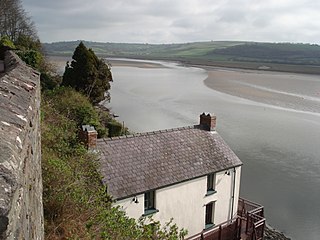
The River Alun is a small river in northwest Pembrokeshire, Wales, which rises near Tretio Common and flows southwestwards to St Davids to empty into St Bride's Bay at the rocky inlet of Porth Clais. [1]
The River Alun is a small river in northwest Pembrokeshire, Wales, which rises near Tretio Common and flows southwestwards to St Davids to empty into St Bride's Bay at the rocky inlet of Porth Clais. [1]

Dyfed is a preserved county in southwestern Wales. It is a mostly rural area with a coastline on the Irish Sea and the Bristol Channel.

The Pembrokeshire Coast Path, often called the Pembrokeshire Coastal Path, is a designated National Trail in Pembrokeshire, southwest Wales. Established in 1970, it is a 186-mile (299 km) long-distance walking route, mostly at cliff-top level, with a total of 35,000 feet (11,000 m) of ascent and descent. At its highest point – Pen yr afr, on Cemaes Head – it reaches a height of 574 feet (175 m), and at its lowest point – Sandy Haven crossing, near Milford Haven – it is just 6 feet (2 m) above low water. Whilst most of the coastline faces west, it offers – at varying points – coastal views in every direction of the compass.

Pembrokeshire Coast National Park is a national park along the Pembrokeshire coast in west Wales.

St Brides Bay is a bay in western Pembrokeshire, West Wales.
The River Taf is a river in West Wales. It rises in the Preseli Hills, Pembrokeshire, and continues through Carmarthenshire to Laugharne. It is one of the three rivers to enter the sea on the east side of Carmarthen Bay. The other two are the River Gwendraeth and River Tywi.

The A478 road is a major road in Wales. The route is from its junction with the A487 at Cardigan, Ceredigion, to Tenby, Pembrokeshire. It crosses the Preseli Hills and winds through farmland for almost all of its route. The road just touches the very west of Carmarthenshire.
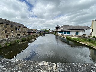
The River Cleddau consists of the Eastern and Western Cleddau rivers in Pembrokeshire, west Wales. They unite to form the Daugleddau estuary and the important harbour of Milford Haven.
Llawhaden is a village, parish and community in the Hundred of Dungleddy, Pembrokeshire, West Wales. The community of Llawhaden includes the parish of Robeston Wathen, part of Narberth and the hamlet of Gelli, and had a population of 634 in 2001, increasing to 688 at the 2011 Census.


Nolton and Roch is a community in the Hundred of Roose, Pembrokeshire, Wales. The community consists essentially of the villages of Nolton and Roch and a number of hamlets including Cuffern and Druidston. The western part of the community is in the Pembrokeshire Coast National Park. Its population (2001) was 746, increasing to 825 at the 2011 census.

Cantref Gwarthaf was the largest of the seven cantrefi of Dyfed in southwest Wales. It subsequently became part of Deheubarth in around 950. It consisted of the southeastern part of Dyfed containing most of the basin of the River Tâf, parts of modern-day Pembrokeshire and Carmarthenshire.

Brawdy is a village and community in Pembrokeshire, Wales.

This is a list of the extreme points and extreme elevations in Wales.

Martin's Haven is a small bay in Pembrokeshire, Wales, UK, on the Dale Peninsula, with views across St Bride's Bay towards St David's. Its shingle beach has a stone slipway which acts as an embarkation point for the ferry which visits the nearby island of Skomer, a national nature reserve, during summer. Martin's Haven lies within the Skomer Marine Conservation Zone and is popular for scuba diving. Grey seals can be seen basking on the rocks. The land is owned by the National Trust.

The Chapel of St Non is located on the coast near St David's in Pembrokeshire, West Wales. Held by tradition to mark the birthplace of St David, the ruin cannot be accurately dated but is unusual in that it is aligned north–south rather than the usual east–west. Near to the ruined chapel is a retreat, a modern chapel and a holy well. The site was protected in the 1950s and is now the responsibility of the Welsh Heritage organisation Cadw.

Cwm Gwaun is a community and valley in north Pembrokeshire, Wales. The community is centred around Pontfaen, a parish and hamlet 4 miles (6.4 km) southeast of Fishguard, and includes the ancient parish of Llanychaer. In 2011, the population was 313. The valley is known for its unspoilt nature and old-world pub, and there are numerous other listed buildings.

Pill Priory is a Tironian house founded near Milford Haven, Pembrokeshire, South West Wales in the late 12th century.

Newport Bay is a bay on a section of the north Pembrokeshire coast, Wales, which is within the Pembrokeshire Coast National Park. The bay is one of many in the much larger Cardigan Bay, and it stretches from Dinas Island to the headland of Pen-y-bâl, two miles to the east. It is overlooked by the town of Newport and the River Nevern flows into the bay.
51°52′N5°17′W / 51.867°N 5.283°W