
Denbighshire is a county in the north-east of Wales. It borders the Irish Sea to the north, Flintshire to the east, Wrexham to the southeast, Powys to the south, and Gwynedd and Conwy to the west. Rhyl is the largest town, and Ruthin is the administrative centre. Its borders differ from the historic county of the same name.
Flintshire, also known as the County of Flint, was one of the thirteen historic counties of Wales, in the north-east of Wales.
The Statute of Rhuddlan, also known as the Statutes of Wales or as the Statute of Wales, was a royal ordinance by Edward I of England, which gave the constitutional basis for the government of the Principality of Wales from 1284 until 1536.

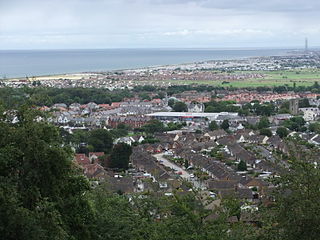
Rhyl is a seaside town and community in Denbighshire in Wales. The town lies on the coast of North Wales, at the mouth of the River Clwyd.
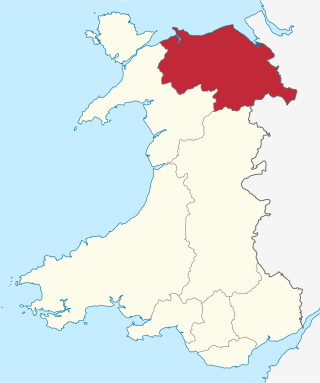
Clwyd is a preserved county of Wales, situated in the north-east corner of the country; it is named after the River Clwyd, which runs through the area. To the north lies the Irish Sea, with the English ceremonial counties of Cheshire to the east and Shropshire to the south-east. Powys and Gwynedd lie to the south and west respectively. Clwyd also shares a maritime boundary with Merseyside along the River Dee. Between 1974 and 1996, a slightly different area had a county council, with local government functions shared with six district councils. In 1996, Clwyd was abolished, and the new principal areas of Conwy County Borough, Denbighshire, Flintshire and Wrexham County Borough were created; under this reorganisation, "Clwyd" became a preserved county, with the name being retained for certain ceremonial functions.

St Asaph is a cathedral city and community on the River Elwy in Denbighshire, Wales. In the 2011 Census it had a population of 3,355, making it the second-smallest city in the United Kingdom in terms of population and urban area. It was historically in Flintshire.

Rhuddlan is a town, community, and electoral ward in Denbighshire, Wales. Its associated urban zone is mainly on the right bank of the Clwyd; it is directly south of seafront town Rhyl. It gave its name to the Welsh district of Rhuddlan from 1974 to 1996. As of the 2001 census, the population was 4,296 decreasing to 3,709 in the 2011 census. It was historically in Flintshire.
Abergele is a market town and community, situated on the north coast of Wales between the holiday resorts of Colwyn Bay and Rhyl, in Conwy County Borough and in the historic county of Denbighshire. Its northern suburb of Pensarn lies on the Irish Sea coast. Abergele and Pensarn railway station serves both resorts.
The Vale of Clwyd is a tract of low-lying ground in the county of Denbighshire in north-east Wales. The Vale extends south-southwestwards from the coast of the Irish Sea for some 20 miles forming a triangle of low ground bounded on its eastern side by the well-defined scarp of the Clwydian Range and to the west by numerous low hills. The River Clwyd which rises within Clocaenog Forest, southwest of Denbigh, runs the full length of the vale. It is joined by the two major left bank tributaries of the River Clywedog and River Elwy and the smaller right bank tributary of the River Wheeler.

The Borough of Rhuddlan was a local government district with borough status from 1974 to 1996, being one of six districts in the county of Clwyd, north-east Wales.

Rhuddlan Castle is a castle located in Rhuddlan, Denbighshire, Wales. It was erected by Edward I in 1277, following the First Welsh War.

Llandyrnog is a large village and community in Denbighshire, Wales lying in the valley of the River Clwyd, about 3 miles (4.8 km) from Denbigh and 5 miles (8.0 km) from Ruthin. The village has good road links to Denbigh and the main A541 road at Bodfari, and is served by buses number 76 and 53. The village contains the Church of St. Tyrnog's is a Grade II* listed building, and has a notable creamery on the outskirts and former hospital. The community includes the settlements of Waen, Ffordd-las and Llangwyfan.
The Vale of Clwyd and Conwy Football League was a football league formed in 2011 following the split of the Clwyd Football League, which itself was formed in 1974 as an amalgamation of the Dyserth and the Halkyn Mountain League. The Premier Division was in the fifth level of the Welsh football league system in North Wales. The league folded in 2020 due to a reorganisation of the Welsh football league pyramid, with many teams joining the North Wales Coast East Football League.
Rhuddlan was a railway station located in Rhuddlan, Denbighshire. It first opened in 1858 as part of the Vale of Clwyd Railway, and afterwards under the auspices of several different companies. The station closed to passengers on 19 September 1955, some seven years after nationalisation.

Llanfair Talhaiarn, abbreviated to Llanfair TH, is a village and community approximately 5 miles (8.0 km) south of Abergele in Conwy county borough, Wales. Until 1974 it was included in Denbighshire. The population was 979 in 2001, increasing to 1,070 at the 2011 census with 44% being Welsh language speakers.

The place-names of Wales derive in most cases from the Welsh language, but have also been influenced by linguistic contact with the Romans, Anglo-Saxons, Vikings, Anglo-Normans and modern English. Toponymy in Wales reveals significant features of the country's history and geography, as well as the development of the Welsh language. Its study is promoted by the Welsh Place-Name Society.
Kinmel Bay and Towyn is a community in Conwy County Borough, in Wales. It is located on the coast bordering Denbighshire, from which it is separated by the River Clwyd, and is 2.6 miles (4.2 km) west of Rhyl, 2.5 miles (4.0 km) north east of Abergele and 14.1 miles (22.7 km) east of Conwy. The community includes the holiday resorts of Kinmel Bay and Towyn. It is crossed by the Afon Gele, which flows from west to east, before joining the River Clwyd on the eastern boundary. At the 2001 census the community had a population of 7,864, increasing to 8,460 at the 2011 census. Before being named Kinmel Bay there was a small settlement called Foryd, which is the name of the bridge crossing into Rhyl. Over half the population were born in England.
The North Wales Coast East Football League is a football league in Wales, at tiers 4 and 5 of the Welsh football league system in north Wales, founded in 2020. The league is under the control of the North Wales Coast Football Association. The league replaced the former Vale of Clwyd and Conwy Football League, and covers the north east of Wales. A corresponding North Wales Coast West Football League was also established at the same time.
The Clwyd Football League was a football league formed in 1974 as an amalgamation of the Dyserth League and the Halkyn Mountain League. The top division was at different periods at the second, third and fourth levels of the Welsh football league system in North Wales. The league ran until 2011 when a split led to the formation of the Clwyd East Football League comprising Flintshire teams under the North East Wales Football Association and the Vale of Clwyd and Conwy Football League, made up of Denbighshire, Conwy county and Vale of Conwy sides, under the North Wales Coast Football Association.

Clwyd North is a constituency of the House of Commons in the UK Parliament, first contested at the 2024 United Kingdom general election, following the 2023 Periodic Review of Westminster constituencies. It is currently represented by Gill German of the Labour Party.
