
Barnstaple is a river-port town in North Devon, England, at the lowest crossing point of the River Taw flowing into the Bristol Channel. From the 14th century, it was licensed to export wool. Great wealth ensued. Later it imported Irish wool, but its harbour silted up and other industries developed, such as shipbuilding, foundries and sawmills. A Victorian market building survives, with a high glass and timber roof on iron columns. The parish had a population of 24,033 at the 2011 census, and the built-up area of 32,411 in 2018. The town area with nearby settlements such as Bishop's Tawton, Fremington and Landkey, had a 2020 population of 46,619.

North Devon is a local government district in Devon, England. North Devon Council is based in Barnstaple. Other towns and villages in the North Devon District include Braunton, Fremington, Ilfracombe, Instow, South Molton, Lynton and Lynmouth. The district was formed on 1 April 1974 as a merger of the Barnstaple municipal borough, the Ilfracombe and Lynton urban districts, and the Barnstaple and South Molton rural districts.

Appledore is a village at the mouth of the River Torridge, about 6 miles (10 km) west of Barnstaple and about 3 miles (5 km) north of Bideford in the county of Devon, England. It is the home of Appledore Shipbuilders, a lifeboat slipway and Hocking's Ice Cream, a brand of ice cream only sold in North Devon. The local football club is Appledore F.C. The ward population at the 2011 census increased to 2,814
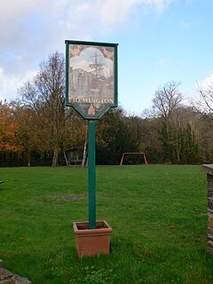
Fremington is a large village, civil parish and former manor in North Devon, England, the historic centre of which is situated three miles (5 km) west of Barnstaple. The village lies between the south bank of the tidal estuary of the River Taw and a small inlet of that river known as Fremington Pill. The parish is surrounded clockwise from the north by the parishes of Heanton Punchardon, Ashford, West Pilton, Barnstaple, Tawstock, Horwood, Lovacott and Newton Tracey, and Instow.

The River Taw rises at Taw Head, a spring on the central northern flanks of Dartmoor, crosses north Devon and close to the sea at the town of Barnstaple, formerly a significant port, empties into Bideford Bay in the Bristol Channel having formed a large estuary of wide meanders which at its western extreme is joined by the estuary of the Torridge.
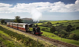
The Lynton & Barnstaple Railway (L&B) opened as an independent railway in May 1898. It was a single track, 1 ft 11+1⁄2 in narrow gauge railway and was slightly over 19 miles (31 km) long running through the rugged and picturesque area bordering Exmoor in North Devon, England. Although opened after the 1896 Light Railways Act came into force, it was authorised and constructed prior to that act. Therefore, as with all other railways, it was authorised under its own Act of Parliament and built to higher standards than similar railways of the time. In the United Kingdom it was notable as being the only narrow gauge line required to use main-line standard signalling. For a short period the line earned a modest return for shareholders, but for most of its life the L&B made a loss. In 1923 the L&B was taken over by the Southern Railway, and eventually closed in September 1935.
The ancient and historic village of Pilton is today a suburb within the town of Barnstaple, one of the oldest boroughs in England. It is located about quarter of a mile north of the town centre in the English county of Devon, in the district of North Devon. In 2009, the Pilton (Barnstaple) ward had a population of 4,239 living in some 1,959 dwellings. It has its own infants and junior school, houses one of Barnstaple's larger secondary schools, and one of Barnstaple's SEN specialist schools. North Devon Hospital is also within West Pilton parish. It has a Church Hall, two public houses, two hotels, and residential homes. It has residential estates of both private and public housing including flats. It also has a historic Church that dates back to at least the 11th Century.

Heanton Punchardon ( ) is a village, civil parish and former manor, anciently part of Braunton Hundred. It is situated directly east-southeast of the village of Braunton, in North Devon. The parish lies on the north bank of the estuary of the River Taw and it is surrounded, clockwise from the north, by the parishes of Braunton, Marwood, Ashford and across the estuary, Fremington. The population was 418 in 1801 and 404 in 1901. Its largest localities are Wrafton and Chivenor. The surrounding area is also an electoral ward with a total population at the 2011 census of 2,673.

Goodleigh is a village, civil parish and former manor in North Devon, England. The village lies about 2+1⁄2 miles (4 km) north-east of the historic centre of Barnstaple. Apart from one adjunct at the south, it is generally a linear settlement.

The River Yeo is a tributary of the River Taw in Devon, England, sometimes known as the Lapford Yeo from the village of Lapford. It is one of several rivers of the same name in Devon, including another tributary of the Taw, the Barnstaple Yeo. The Lapford Yeo flows within 2 miles of the headwaters of another River Yeo, which is a tributary of the River Creedy.
The Priory of St Mary Magdalene in Barnstaple was a priory in Devon, England. It was founded in about 1107 by Juhel de Totnes, feudal baron of Barnstaple, who had earlier founded Totnes Priory in about 1087 at the caput of his former feudal barony of Totnes, from which he had been expelled. Barnstaple Priory was of the Cluniac order, and was senior to all others of that order in England. It was dedicated to St Mary Magdalene. It was situated on land outside the town walls stretching from the North Gate to the East Gate with the River Yeo forming its northern boundary. Nearby to the north across the River Yeo was the Benedictine Pilton Priory of St Mary the Virgin, a cell of Malmesbury Abbey, founded slightly later, between 1107 and 1199.

The historic manor of Raleigh, near Barnstaple and in the parish of Pilton, North Devon, was the first recorded home in the 14th century of the influential Chichester family of Devon. It was recorded in the Doomsday Book of 1086 together with three other manors that lie within the later-created parish of Pilton. Pilton as a borough had existed long before the Norman Conquest and was one of the most important defensive towns in Devon under the Anglo-Saxons. The manor lies above the River Yeo on the southern slope of the hill on top of which exists the ruins of the Anglo-Saxon hillfort of Roborough Castle. The historic manor of Raleigh is now the site of the North Devon District Hospital.

The River Yeo is a tributary to the River Creedy. It is located in Devon, England, and its headwaters float within two miles of a different River Yeo, which is a tributary to River Taw.

Pilton House in the parish of Pilton, near Barnstaple, North Devon, Ex31, is an historic grade II listed Georgian mansion house built in 1746 by Robert Incledon (1676-1758), twice Mayor of Barnstaple, who was from nearby Braunton. It is situated almost in the centre of the ancient town of Pilton, but had formerly extensive grounds covering at least 20 acres, which extended down "Pilton Lawn", now built over, to the River Yeo. It later served as the residence for various Members of Parliament for Barnstaple, for which it was well suited being only a 10-minute walk from the centre of that town, yet in a secluded situation with extensive grounds, and sufficiently large and grand for entertaining borough officials and electors.
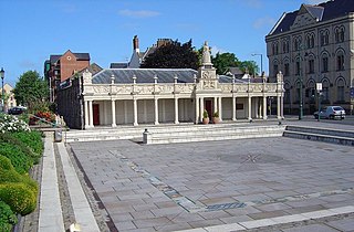
Queen Anne's Walk is a grade I listed building in the town of Barnstaple, North Devon, completed in 1713 as a meeting place for the town's merchants. It is believed to have been designed by the architect William Talman, on the basis of its similarity to his work at the Hall in Drayton, Northamptonshire. It was promoted and financed by the thirteen members of the Corporation of Barnstaple whose armorials are sculpted on and above the parapet, and the work was overseen by Robert Incledon (1676–1758), Mayor of Barnstaple in 1712–13. It has been owned for many decades by North Devon District Council, which currently (2014) leases it to Barnstaple Town Council, and now trades as The Cafe on the Strand.

Yeotown was a historic estate situated in the parish of Goodleigh, North Devon, about 1 1/2 miles north-east of the historic centre of Barnstaple. The mansion house was remodelled in about 1807 in the neo-gothic style by Robert Newton Incledon (1761-1846), eldest son of Benjamin Incledon (1730-1796) of Pilton House, Pilton, near Barnstaple, an antiquarian and genealogist and Recorder of the Borough of Barnstaple (1758–1796). It was demolished during his lifetime and today only one of the large gatehouse survives, since converted into a farmhouse known as Ivy Lodge. The surviving drawing of the house in the collection of the North Devon Athaneum in Barnstaple shows a large chapel, or small church, with a tall square three-storied pinnacled tower attached to the house.

Sir Nicholas II Hooper (1654-1731) of Fullabrook, Braunton and Raleigh, Pilton in Devon, was a lawyer who served as Tory Member of Parliament for Barnstaple 1695-1715.

Hawkridge in the parish of Chittlehampton in North Devon, England, is an historic estate, anciently the seat of a junior branch of the Acland family which originated at nearby Acland, in the parish of Landkey and later achieved great wealth and prominence as the Acland Baronets of Killerton, near Exeter. The former mansion house is today a farmhouse known as Hawkridge Barton, a grade II* listed building. The Devon historian Hoskins (1959) stated of Hawkridge: "Externally there is nothing remarkable except a decaying avenue of ancient walnuts, so often the first indication of a 16th or 17th century mansion". The interior contains a fine plaster heraldic overmantel showing the arms of Acland impaling Tremayne, representing the 1615 marriage of Baldwin Acland (1593–1659) of Hawkridge and Elizabeth Tremayne.

Pilton West is a rural civil parish of North Devon, England, immediately north-west of the suburb of Pilton in the town of Barnstaple. In 2019, the population of Pilton West was 253, and its area was around 1.6 square miles. The parish is older than the national average — 28% of the local residents are over 65, compared to 18% of the British population — and it is overwhelmingly white, with the 2011 census finding that all but one of the parish's residents identified themselves as white. It elects a parish council, the clerk of which is Geoff Dwyer.
