
Dartmouth is a town and civil parish in the English county of Devon. It is a tourist destination set on the western bank of the estuary of the River Dart, which is a long narrow tidal ria that runs inland as far as Totnes. It lies within the South Devon Area of Outstanding Natural Beauty and South Hams district, and had a population of 5,512 in 2001, reducing to 5,064 at the 2011 census. There are two electoral wards in the Dartmouth area. Their combined population at the above census was 6,822.

Plymouth is a port city and unitary authority in Devon, South West England. It is located on the south coast of Devon, approximately 36 miles (58 km) southwest of Exeter and 193 miles (311 km) southwest of London. It is bordered by Cornwall to the west and southwest.

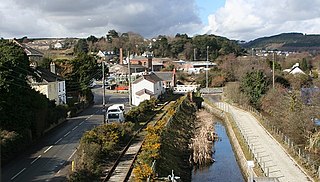
Great Torrington is a market town in Devon, England. Parts of it are sited on high ground with steep drops down to the River Torridge below, with the lower-lying parts of the town prone to occasional flooding. Torrington is in the centre of Tarka Country, a landscape captured by Henry Williamson in his novel Tarka the Otter in 1927. Great Torrington has one of the most active volunteering communities in the United Kingdom.

The Tamar is a river in south west England that forms most of the border between Devon and Cornwall. A part of the Tamar Valley is a World Heritage Site due to its historic mining activities.

The South West Coast Path is England's longest waymarked long-distance footpath and a National Trail. It stretches for 630 miles (1,014 km), running from Minehead in Somerset, along the coasts of Devon and Cornwall, to Poole Harbour in Dorset. Because it rises and falls with every river mouth, it is also one of the more challenging trails. The total height climbed has been calculated to be 114,931 ft (35,031 m), almost four times the height of Mount Everest. It has been voted 'Britain's Best Walking route' twice in a row by readers of The Ramblers' Walk magazine, and regularly features in lists of the world's best walks.

The River Dart is a river in Devon, England, that rises high on Dartmoor and flows for 75 kilometres (47 mi) to the sea at Dartmouth.

Exmouth is a port town, civil parish and seaside resort, sited on the east bank of the mouth of the River Exe and 11 miles (18 km) southeast of Exeter.

Ivybridge is a town and civil parish in the South Hams, in Devon, England. It lies about thirteen miles east of Plymouth. It is at the southern extremity of Dartmoor, a National Park of England and Wales and lies along the A38 "Devon Expressway" road. There are two electoral wards in Ivybridge East and Ivybridge West with a total population of 11,851.

North Devon is a local government district in Devon, England. Its council is based just outside Barnstaple, the district's largest town. The district also includes the towns of Ilfracombe, Lynton and Lynmouth and South Molton along with numerous villages and surrounding rural areas.

New Ferry is an urban area on the Metropolitan Borough of Wirral, Merseyside, England. It is located on the Wirral Peninsula, with the River Mersey to the east and the town of Bebington to the west. Within the boundaries of the historic county of Cheshire, the area was developed from the early nineteenth century.
Kingswear is a village and civil parish in the South Hams area of the English county of Devon. The village is located on the east bank of the tidal River Dart, close to the river's mouth and opposite the small town of Dartmouth. It lies within the South Devon Area of Outstanding Natural Beauty, and has a population of 1,332, reducing to 1,217 at the 2011 census.

Paisley Gilmour Street railway station is the largest of the four stations serving the town of Paisley, Renfrewshire, Scotland, and acts as the town's principal railway station. The station is managed by ScotRail and serves the Ayrshire Coast Line and Inverclyde Line, 7+1⁄4 miles (11.7 km) west of Glasgow Central. The station is protected as a category B listed building.
Fosse a ditch or moat, may also refer to:

Ipswich railway station is located on the Main line in Queensland, Australia. It serves the urban centre of Ipswich.

The A379 is a road in the English county of Devon. It links points on the edges of that county's two principal cities, Exeter and Plymouth, by an indirect and largely coastal route. The A38 provides a faster and more direct inland route between Exeter and Plymouth, whilst the A380 provides a similarly faster route between Exeter and the Torbay area. However the A379 serves many small coastal communities and ports along the coast. The indented nature of the South Devon coast means that the road is usually out of sight of the sea, but the many rivers and estuaries are crossed by bridges and, in one case, a cable ferry.
Riverlink Shopping Centre is a mall located in the northern area of the CBD of Ipswich, Queensland, Australia. Stage One was opened on 5 April 2007, whereas Stage 2 opened on 31 May 2007.
The evolution of transport in Cornwall has been shaped by the county's strong maritime, mining and industrial traditions and much of the transport infrastructure reflects this heritage.
Tillicum or Tilikum is a word in Chinook Jargon that means people, family, tribe, and relatives, and may refer to:
The Dartmouth Ferry, sometimes called the Kingswear Ferry, may refer to one of three ferries that link Dartmouth and Kingswear, on opposite sides of the River Dart in the English county of Devon. From north to south, these ferries are:
Exeter is a cathedral city and the county town of Devon, South West England. It is situated on the River Exe, approximately 36 mi (58 km) northeast of Plymouth and 65 mi (105 km) southwest of Bristol.