Rivière-Koksoak, Quebec

Last updated
Rivière-Koksoak
Unorganized territory
Canada Quebec location map 2.svg
Red pog.svg
Rivière-Koksoak
Coordinates: 57°10′N69°20′W / 57.167°N 69.333°W / 57.167; -69.333 Coordinates: 57°10′N69°20′W / 57.167°N 69.333°W / 57.167; -69.333 [1]
CountryFlag of Canada.svg  Canada
Province Flag of Quebec.svg  Quebec
Region Nord-du-Québec
TE Kativik
Constituted January 1, 1986
Government [2]
   Federal riding Abitibi—Baie-James—Nunavik—Eeyou
   Prov. riding Duplessis and Ungava
Area [2] [3]
  Total 346,429.30 km2 (133,757.10 sq mi)
  Land 307,039.90 km2 (118,548.77 sq mi)
Population (2011) [3]
  Total 0
  Density 0.0/km2 (0/sq mi)
  Change (2006–11)Decrease2.svg100.0%
  Dwellings 0
Time zone EST (UTC−5)
  Summer (DST) EDT (UTC−4)

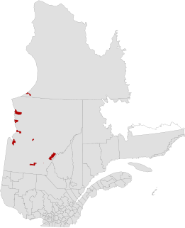
Rivière-Koksoak is a very large unorganized territory in the Kativik Regional Government territory in the Nord-du-Québec region of Quebec. It is named after the Koksoak River.

Kativik Regional Government

The Kativik Regional Government encompasses most of the Nunavik region of Quebec. Nunavik is the northern half of the Nord-du-Québec administrative region and includes all the territory north of the 55th parallel. The administrative capital is Kuujjuaq, on the Koksoak River, about 50 kilometres inland from the southern end of the Ungava Bay.

Nord-du-Québec Place in Quebec, Canada

Nord-du-Québec is the largest, but the least populous, of the seventeen administrative regions of Quebec, Canada. With nearly 750,000 square kilometres (290,000 sq mi) of land area, and very extensive lakes and rivers, it covers much of the Labrador Peninsula and about 55% of the total land surface area of Quebec, while containing a little more than 0.5% of the population.

Koksoak River river Koksoak is a river of Nunavik (in watershed of Ungava Bay), flowing in unorganized territory of Rivière-Koksoak, in administrative region of Nord-du-Québec, in Quebec, in Canada

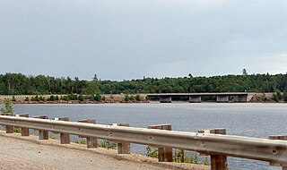
The Koksoak River is a river in northern Quebec, Canada, the largest river in the Nunavik region. The Inuit village and region's administrative center Kuujjuaq lies on the shores of the Koksoak, about 50 kilometres (31 mi) south from its mouth.

It consists of nearly the entire eastern part of northernmost Quebec. Bordering it to the west is the other large unorganized territory in Kativik, Baie-d'Hudson.

Baie-dHudson, Quebec Unorganized territory in Quebec, Canada

Baie-d'Hudson is a very large unorganized territory in the Kativik Regional Government territory in the Nord-du-Québec region of Quebec. It is named after Hudson Bay.

Its population in the Canada 2011 Census was 0; enclaved within it, however, are various northern villages (i.e., Inuit communities) and one (uninhabited) Naskapi village municipality. In the 2006 census it had a population of 15.

The Inuit are a group of culturally similar indigenous peoples inhabiting the Arctic regions of Greenland, Canada, and Alaska. The Inuit languages are part of the Eskimo-Aleut family. Inuit Sign Language is a critically endangered language isolate used in Nunavut.

Riviere-Koksoak.png

Related Research Articles

The term regional county municipality or RCM is used in Quebec to refer to one of 87 county-like political entities. In some older English translations they were called county regional municipality.

Kuujjuaq Northern village municipality in Quebec, Canada

Kuujjuaq is the largest northern village in Nunavik, Quebec, Canada with a population of 2,754 as of the Canada 2016 Census. It is the administrative capital of the Kativik Regional Government and lies on the western shore of the Koksoak River.

Aupaluk Northern village municipality in Quebec, Canada

Aupaluk is a northern village in Nunavik, in the Nord-du-Québec region of Quebec. It is the least-populous Inuit community in Nunavik.

The province of Quebec is divided into units at the regional, supralocal and local levels. The primary types of subdivision are administrative regions, regional county municipalities (RCMs), metropolitan communities (CMs), the Kativik Regional Government (KRG), unorganized territories (TNOs), agglomerations, northern villages, Cree villages, Naskapi villages, and a variety of local units which may collectively be referred to as local municipalities and boroughs.

Kativik, Quebec territory equivalent to a regional county municipality of Quebec

Kativik is a territory equivalent to a regional county municipality (TE) of Quebec, with geographical code 992. Its land area is 443,372.20 km², and its population was 12,090 at the 2011 Census of Canada.

Eeyou Istchee (territory) equivalent territory

Eeyou Istchee is a territory equivalent to a regional county municipality (TE) of Quebec, represented by the Grand Council of the Crees. On July 24, 2012, the Quebec government signed an accord with the Cree Nation that resulted in the abolition of the neighbouring municipality of Baie-James and the creation of the new Eeyou Istchee James Bay Regional Government, providing for the residents of neighbouring Jamésie TE and Eeyou Istchee to jointly govern the territory formerly governed by the municipality of Baie-James.

Kangiqsujuaq Northern village municipality in Quebec, Canada

Kangiqsujuaq is a northern village in Nunavik, Nord-du-Québec, Quebec, Canada. It had a population of 750 in the Canada 2016 Census. The community has also been known as Wakeham Bay. The name "Kangiqsujuaq" means "the large bay" in Inuktitut.

Laniel, Quebec Unorganized territory in Quebec, Canada

Laniel is an unorganized territory in the Témiscamingue Regional County Municipality, Abitibi-Témiscamingue region, Quebec, Canada. It surrounds the northern portion of Lake Kipawa.

Lac-Lenôtre, Quebec Unorganized territory in Quebec, Canada

Lac-Lenôtre is an unorganized territory in the Outaouais region of Quebec, Canada. It is one of the five unorganized territories in the La Vallée-de-la-Gatineau Regional County Municipality. It is named after Lake Lenôtre.

Lac-Duparquet, Quebec Unorganized territory in Quebec, Canada

Lac-Duparquet is an unorganized territory in the Abitibi-Témiscamingue region of Quebec, Canada. It is one of two unorganized territories in the Abitibi-Ouest Regional County Municipality but the only one without a permanent population. It is located between Duparquet Lake and the Quebec/Ontario border.

Réservoir-Dozois, Quebec Unorganized territory in Quebec, Canada

Réservoir-Dozois is an unorganized territory in the Abitibi-Témiscamingue region of Quebec, Canada. It is the largest of five unorganized territories in the La Vallée-de-l'Or Regional County Municipality and entirely part of the La Vérendrye Wildlife Reserve.

Kangirsuk Northern village municipality in Quebec, Canada

Kangirsuk is an Inuit village in northern Nunavik, Quebec, Canada. It is 230 kilometres (140 mi) north of Kuujjuaq, between Aupaluk and Quaqtaq. The community is only accessible by air and, in late summer, by boat. The village used to be known also as Payne Bay and Bellin.

Lac-Metei, Quebec Unorganized territory in Quebec, Canada

Lac-Metei is an unorganized territory in the Abitibi-Témiscamingue region of Quebec, Canada. It is one of five unorganized territories in the La Vallée-de-l'Or Regional County Municipality.

Lac-Douaire, Quebec Unorganized territory in Quebec, Canada

Lac-Douaire is an unorganized territory of Quebec, Canada. It is the largest geo-political division in the Laurentides region, and one of eleven unorganized areas in the Antoine-Labelle Regional County Municipality.

Lac-Marguerite, Quebec Unorganized territory in Quebec, Canada

Lac-Marguerite is an unorganized territory in Antoine-Labelle Regional County Municipality in the Laurentides region of Quebec, Canada.

Kawawachikamach (Naskapi village municipality) Naskapi village municipality in Quebec, Canada

Kawawachikamach is a Naskapi village municipality in the territory of the Kativik Regional Government in northern Quebec; in fact, it is the only Naskapi village municipality, but nevertheless has a distinct legal status and classification from other kinds of village municipalities in Quebec: Cree village municipalities, northern villages, and ordinary villages.

References