Related Research Articles

Ventnor is a seaside resort town and civil parish established in the Victorian era on the southeast coast of the Isle of Wight, England, eleven miles (18 km) from Newport. It is situated south of St Boniface Down, and built on steep slopes leading down to the sea. The higher part is referred to as Upper Ventnor ; the lower part, where most amenities are located, is known as Ventnor. Ventnor is sometimes taken to include the nearby and older settlements of St Lawrence and Bonchurch, which are covered by its town council. The population is 5,567 according to the 2021 Census
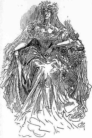
Miss Havisham is a character in the Charles Dickens novel Great Expectations (1861). She is a wealthy spinster, once jilted at the altar, who insists on wearing her wedding dress for the rest of her life. She lives in a ruined mansion with her adopted daughter, Estella. Dickens describes her as looking like "the witch of the place". In the novel, she schemes to have the young orphan, Pip, fall in love with Estella, so that Estella can "break his heart."

St Boniface Down is a chalk down near Ventnor, on the Isle of Wight, England. Its summit, 241 metres (791 ft), is the highest point on the island, with views on a clear day stretching over 70 miles from Beachy Head to the east, Walbury Hill to the north, the Isle of Portland to the west and the French coast of Normandy to the south. It is 1 kilometre (0.6 mi) north of the town. There is reputed to be a wishing well on its southern slope, which requires the wisher to climb up from the south without looking back. In 1545, a French invasion force attempted this against a force of the Isle of Wight Militia commanded by Sir John Fyssher – which allegedly included several women archers- and were routed. In 1940, the radar station was bombed by Ju 87 Stuka dive bombers, which is reconstructed in the film "The Battle of Britain". The top is surmounted by a round barrow.

Bonchurch is a small village in the civil parish of Ventnor, to the east of the town of Ventnor, now largely connected to the latter by suburban development, on the southern part of the Isle of Wight, England. One of the oldest settlements on the Isle of Wight, it is situated on The Undercliff adjacent to the Bonchurch Landslips Site of Special Scientific Interest. The main village is backed by a cliff to the north, with the Upper Bonchurch section on the clifftop halfway up St Boniface Down on the main A3055 road.
The Battle of Bonchurch took place in late July 1545 at Bonchurch on the Isle of Wight. No source gives the precise date, although 21 July is possible from the sequence of events. The battle was a part of the wider Italian War of 1542–1546, and took place during the French invasion of the Isle of Wight. Several landings were made, including at Bonchurch. Most accounts suggest that England won the battle, and the French advance across the island was halted.
Chevalier D'Aux was a senior French commander who, while leading a foraging party into the Isle of Wight to search for sources of clean water to replenish the stocks of a French fleet, which had just been forced to retire from Portsmouth, was attacked and killed in July 1545 by a group of the local Isle of Wight militia, at Bonchurch.

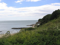
Monks Bay is situated on the southern coast of the Isle of Wight, England just to the east of the village of Bonchurch, it is around 1⁄3 mile (0.54 km) in length. It is popular with visitors and is one of the natural highlights of the town, which has hosted such figures as Charles Dickens. The bay is also a good site for local flora, and it has a row of houses which look out to the English Channel.

Luccombe is a hamlet a short distance south of Shanklin, on the south coast of the Isle of Wight, England.

The French invasion of the Isle of Wight occurred during the Italian Wars in July 1545. The invasion was repulsed.
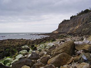
Bonchurch Landslips is a 28.2-hectare (70-acre) site of special scientific interest which is located north-east of Ventnor, Isle of Wight. A wooded coastal landslip zone, the site was notified in 1977 for both its biological and geological features.

Old St Boniface Church, Bonchurch is a parish church in the Church of England located in Bonchurch, Isle of Wight.

Steel Bay is a bay on the south-east coast of the Isle of Wight, England. It lies to the east of the village of Bonchurch. It faces south-east towards the English Channel and has a one-half-mile (0.80 km) shoreline. It stretches from Bordwood Ledge in the north to Dunnose headland in the south. The bay is remote and has no established access. It is best viewed from Dunnose which can be accessed by scrambling over The Landslip, which is close to the Isle of Wight Coastal Path in the woods to the east of Upper Bonchurch. The bay has a large intertidal reef with outlying rocks, which can be a danger for marine traffic.

Horseshoe Bay is a bay on the south-east coast of the Isle of Wight, England. It lies to the south-east of the village of Bonchurch. It faces south-east towards the English Channel and its shoreline is approximately 250 yards (230 m) in length. It should not be confused with a similarly named bay about 8 miles (13 km) along the shoreline to the north near Culver Down.

Elizabeth Missing Sewell was an English author of religious and educational texts notable in the 19th century. As a home tutor, she devised a set of influential principles of education.
Bonchurch Manor is a manor house on the Isle of Wight, situated in Bonchurch.

The Devil's Chimney was a scenic rock cleft with steps that descended into the Bonchurch Landslips between Bonchurch and Luccombe, Isle of Wight.
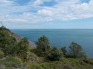
The Undercliff, Isle of Wight, England is a tract of semi-rural land, around 5 miles (8.0 km) long by 0.25–0.5 miles (0.40–0.80 km) wide, skirting the southern coast of the island from Niton to Bonchurch. Named after its position below the escarpment that backs this coastal section, its undulating terrain comprises a mix of rough pasture, secondary woodland, parkland, grounds of large isolated houses, and suburban development. Its sheltered south-facing location gives rise to a microclimate considerably warmer than elsewhere on the island. Although inhabited, the Undercliff is an area prone to landslips and subsidence, with accompanying loss of property over time. Settlements along the Undercliff, from west to east, are: lower Niton, Puckaster, St Lawrence, Steephill, the town of Ventnor, and Bonchurch.
Events from the year 1545 in France.
References
- ↑ John Goodwin, Bonchurch from A-Z. The Bonchurch Trading Company, 1992, p. 7.
| | This English biographical article related to the military is a stub. You can help Wikipedia by expanding it. |