
Robin Hood's Butts are a group of nine Bronze Age barrows near Otterford on the Blackdown Hills in Somerset, England. They have been scheduled as ancient monuments.
Robin Hood's Butts are a group of nine Bronze Age barrows near Otterford on the Blackdown Hills in Somerset, England. They have been scheduled as ancient monuments.
Two of the bowl barrows 210 metres (690 ft) and 600 metres (2,000 ft) north west of Brown Down Cottage are between 28 metres (92 ft) and 88 metres (289 ft) in diameter. [1] The two 380 metres (1,250 ft) west and 685 metres (2,247 ft) north west of Beech Croft are slightly larger with one being 42 metres (138 ft) and the other 44 metres (144 ft) in diameter. [2]
The other barrows are of the round barrow type and are located 100 metres (330 ft) south of School Farm. Four are bowl shaped and the other a bell barrow. [3]
The origin of the name is unknown, however local folklore describes their use by Robin Hood and Little John to play quoits. [4] [5] The name is known to have been used since the 19th century appearing on a tithe map created in 1844. [6]
Dunkery Beacon at the summit of Dunkery Hill is the highest point on Exmoor and in Somerset, England. It is also the highest point in southern England outside of Dartmoor.

The Blackdown Hills National Landscape is a National Landscape along the Somerset-Devon border in south-western England, which were designated in 1991 as an Area of Outstanding Natural Beauty (AONB). In November 2023, it has become 'Blackdown Hills National Landscape' The area encompasses a set of hills of the same name.

Cothelstone is a village and civil parish in Somerset, England, situated in the Quantock Hills six miles north of Taunton. The parish, which includes the hamlet of Toulton, has a population of 111.

Otterford is a village and civil parish in Somerset, England. It is situated on the Blackdown Hills, 7 miles (11.3 km) south of Taunton. The village has a population of 356.

West Bagborough is a village and civil parish in Somerset, England, about 5 miles (8.0 km) north of Taunton. In 2011, the village had a population of 358.
Black Down is the highest hill in the Mendip Hills, Somerset, in south-western England. Black Down lies just a few miles eastward of the Bristol Channel at Weston-super-Mare, and provides a view over the Chew Valley. The summit is marked with an Ordnance Survey trig point, the base of which has been rebuilt by the Mendip Hills AONB authority.

Shiplate Slait is a 33.9 hectare biological Site of Special Scientific Interest near the village of Loxton, within the Mendip Hills Area of Outstanding Natural Beauty, North Somerset, notified in 1987.
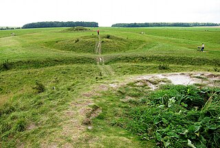
The Cursus Barrows is the name given to a Neolithic and Bronze Age round barrow cemetery lying mostly south of the western end of the Stonehenge Cursus, in Wiltshire, England. The cemetery contains around 18 barrows scattered along an east-to-west ridge, although some of the mounds are no longer visible. The Cursus Barrows can be seen just north of the route between the Stonehenge Visitor Centre and Stonehenge.
Battlegore Burial Chamber is a Bronze Age burial chamber located in Williton, Somerset. It is composed of three round barrows and possibly a long, chambered barrow. The site was excavated in 1931 by George Gray. The name "Battlegore" comes from this site being attributed to the location of a Danish raid in 918 AD or 988 AD. At least as early as the 14th century, the site was referred to as "Bytelgore", a predecessor of the word "Battlegore". Along with three nearby round barrows it has been scheduled as an ancient monument.
Drove Cottage Henge is a scheduled monument in the Priddy parish of Somerset, England. It is located 370 metres (1,210 ft) north of Drove Cottage. The site is a ceremonial Neolithic location. Since this henge is one of only around 80 henges throughout England, it is considered to be nationally important.

Sand Point in Somerset, England, is the peninsula stretching out from Middle Hope, an 84.1-hectare (208-acre) biological and geological Site of Special Scientific Interest. It lies to the north of the village of Kewstoke, and the stretch of coastline called Sand Bay north of the town of Weston-super-Mare. On a clear day it commands views over Flat Holm, of the Bristol Channel, South Wales, Clevedon, the Second Severn Crossing and the Severn Bridge. A line drawn between Sand Point and Lavernock Point in South Wales marks the lower limit of the Severn Estuary and the start of the Bristol Channel.

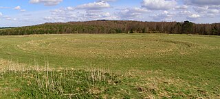
Priddy Nine Barrows Cemetery and Ashen Hill Barrow Cemetery are a collection of round barrows, dating from the Bronze Age, near Priddy in the English county of Somerset. They are designated as ancient monuments.

Taunton Deane was a local government district with borough status in Somerset, England. It merged with West Somerset to form Somerset West and Taunton on 1 April 2019. Its council was based in Taunton. The district was formed on 1 April 1974, under the Local Government Act 1972, by a merger of the Municipal Borough of Taunton, Wellington Urban District, Taunton Rural District, and Wellington Rural District. Taunton Deane was granted borough status in 1975, enabling the mayoralty of Taunton to be continued, when other districts did not have mayors. The district was given the name of an alternate form of the Taunton Deane Hundred.

Mendip is a local government district of Somerset in England. The Mendip district covers a largely rural area of 285 square miles (738 km2) ranging from the Mendip Hills through on to the Somerset Levels. It has a population of approximately 110,000. The administrative centre of the district is Shepton Mallet but the largest town is Frome.

Trevelgue Head, also known as Porth Island, is a headland north-east of Newquay, Cornwall, England, next to Porth at the eastern end of Newquay Bay.

Thundersbarrow Hill is an archaeological site in West Sussex, England. It is on a chalk ridge, aligned north-west to south-east, on the South Downs north of Shoreham-by-Sea.
West Somerset was a local government district in the English county of Somerset. It merged with Taunton Deane to form Somerset West and Taunton on 1 April 2019.
Oakley Down Barrow Cemetery is a group of Bronze Age round barrows on Cranborne Chase, about 1 mile (1.6 km) east of the village of Sixpenny Handley in Dorset, England. It is a scheduled monument.