Related Research Articles

Newcastle is a small seaside resort town in County Down, Northern Ireland, which had a population of 7,672 at the 2011 Census. It lies by the Irish Sea at the foot of Slieve Donard, the highest of the Mourne Mountains. Newcastle is known for its sandy beach, forests, and mountains. The town lies within the Newry, Mourne and Down District.

County Down is one of the six counties of Northern Ireland, one of the nine counties of Ulster and one of the traditional thirty-two counties of Ireland. It covers an area of 961 sq mi (2,490 km2) and has a population of 531,665. It borders County Antrim to the north, the Irish Sea to the east, County Armagh to the west, and County Louth across Carlingford Lough to the southwest.
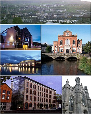
Newry is a city in Northern Ireland, standing on the Clanrye river in counties Down and Armagh. It is near the border with the Republic of Ireland, on the main route between Belfast and Dublin. It had a population of 26,967 in 2011.

Newry and Mourne District Council was a local council in Northern Ireland. It merged with Down District Council in May 2015 under local government reorganisation in Northern Ireland to become Newry, Mourne and Down District Council.

Down District Council was a Local Council in County Down in Northern Ireland. It merged with Newry and Mourne District Council in April 2015 under local government reorganisation in Northern Ireland to become Newry, Mourne and Down District Council.

The Mourne Mountains, also called the Mournes or Mountains of Mourne, are a granite mountain range in County Down in the south-east of Northern Ireland. They include the highest mountains in Northern Ireland, the highest of which is Slieve Donard at 850 m (2,790 ft). The Mournes are designated an Area of Outstanding Natural Beauty and it has been proposed to make the area Northern Ireland's first national park. The area is partly owned by the National Trust and sees many visitors every year. The Mourne Wall crosses fifteen of the summits and was built to enclose the catchment basin of the Silent Valley and Ben Crom reservoirs.

South Down is a parliamentary constituency in the United Kingdom House of Commons. The current MP for the constituency is Chris Hazzard of Sinn Féin.

Annalong is a seaside village in County Down, Northern Ireland at the foot of the Mourne Mountains. Annalong is in the civil parish of Kilkeel, the barony of Mourne, and the Newry and Mourne District Council area. It had a population of 1,805 at the 2011 Census. The village formerly exported dressed granite and is now a fishing and holiday resort.
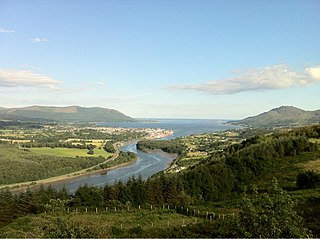
Carlingford Lough is a glacial fjord or sea inlet in northeastern Ireland, forming part of the border between Northern Ireland to the north and the Republic of Ireland to the south. On its northern shore is County Down, the Mourne Mountains, and the town of Warrenpoint; on its southern shore is County Louth, the Cooley Mountains and the village of Carlingford. The Newry River flows into the loch from the northwest.

Conor Terence Murphy is an Irish republican Sinn Féin politician who is the Member of the Legislative Assembly of Northern Ireland for Newry and Armagh. He served as the Member of Parliament for Newry and Armagh from 2005 until 2015.

The Newry Canal, located in Northern Ireland, was built to link the Tyrone coalfields to the Irish Sea at Carlingford Lough near Newry. It was the first summit level canal to be built in Ireland or Great Britain, and pre-dated the more famous Bridgewater Canal by nearly thirty years and Sankey Canal by fifteen years. It was authorised by the Commissioners of Inland Navigation for Ireland, and was publicly funded. It was opened in 1742, but there were issues with the lock construction, the width of the summit level and the water supply. Below Newry, the Newry Ship Canal was opened in 1769, and both Newry and the canal flourished.

Newry River and River Clanrye are names for one of the rivers of Ireland. The river passes through the city of Newry and empties into Carlingford Lough near Warrenpoint.

Camlough is a village five kilometres west of Newry in County Armagh, Northern Ireland. The village is named after a lake, known as Cam Lough, in the parish, which is about 90 acres in extent. South of the village is Camlough Mountain which is part of the Ring of Gullion. The Ring of Gullion is a geological formation and area and is officially designated as an Area of Outstanding Natural Beauty, (AONB). Camlough had a population of 1,074 at the 2011 Census.

Drumaness is a village and townland in the Newry, Mourne and Down District Council area of County Down, Northern Ireland. It is 3 miles or 5 kilometres south of Ballynahinch, beside the main A24 Belfast to Newcastle road. It is situated in the civil parish of Magheradroll and the historic barony of Kinelarty. In the 2011 Census it had a population of 1,339 people.
Dunnaval is a small village and townland near Kilkeel in County Down, Northern Ireland. It is situated in the civil parish of Kilkeel and the historic barony of Mourne. In the 2001 Census it had a population of 147 people. It lies within the Newry and Mourne District Council area.
Frank Feely is an Irish nationalist politician in Northern Ireland.
Mourne was a constituency of the Parliament of Northern Ireland.
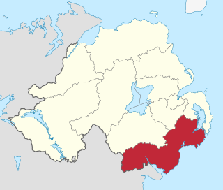
Newry, Mourne and Down is a local government district in Northern Ireland that was created on 1 April 2015 by merging Newry and Mourne District and Down District. It covers most of the southeastern part of Northern Ireland. The local authority is Newry, Mourne and Down District Council.
Newry, Mourne and Down District Council is a local authority in Northern Ireland that was established on 1 April 2015. It replaces Down District Council and Newry and Mourne District Council and covers most of the southeast of Northern Ireland. The first elections to the authority were on 22 May 2014. At the 2019 Northern Ireland local elections, Sinn Féin became the largest party with 16 seats.

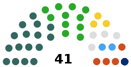
The first election to Newry, Mourne and Down District Council, part of the Northern Ireland local elections on 22 May 2014, returned 41 members to the newly formed council via Single Transferable Vote. Sinn Féin and the Social Democratic and Labour Party won the most seats, with 14 each, with Sinn Féin taking a plurality of first-preference votes.
References
- ↑ MassonJim (26 July 2013). "Newcastle Rock Pool Celebrates Eightieth Year". Down News. Retrieved 2 December 2015.
- 1 2 Ferguson, Amanda (9 February 2015). "Newcastle's 100-year-old open-air sea water swimming pool faces closure threat in bid to save just £45,000". Belfast Telegraph. Retrieved 2 December 2015.
- 1 2 "Still in the swim at 80 years old". Irish News. 19 August 2013. Retrieved 2 December 2015.
- 1 2 Newcastle Area Community Association (Davey, Bernard). The Quay and The Rock. Mourne Observer Press. pp. 78–79.
- ↑ "Petition launched to save Rock Pool in Newcastle". Down Recorder. 4 February 2015. Retrieved 2 December 2015.
- ↑ "Newcastle rock pool saved from closure". UTV. 11 February 2015. Retrieved 2 December 2015.
- ↑ Down District Council Recreation Committee Meeting Archived 2014-01-20 at the Wayback Machine , 23 June 2008
Coordinates: 54°12′13″N5°53′29″W / 54.2036°N 5.8914°W
| | This swimming-related article is a stub. You can help Wikipedia by expanding it. |