
Whitefish Township is a civil township of Chippewa County in the U.S. state of Michigan. The population was 575 at the 2010 census.
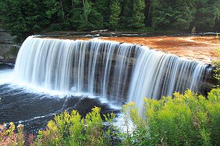
The Tahquamenon Falls are two different waterfalls on the Tahquamenon River. Both sets are located near Lake Superior in the eastern Upper Peninsula of Michigan. The water is notably brown in color from the tannins leached from the cedar swamps which the river drains. The upper falls are more than 200 feet across and with a drop of approximately 48 feet During the late spring runoff, the river drains as much as 50,000 US gallons (190,000 L) of water per second, making the upper falls the third most voluminous vertical waterfall east of the Mississippi River, after Niagara Falls and Cohoes Falls, both in New York State.
Gull Island is the name of a dozen small islands in the U.S. state of Michigan.
Carp River is a 40.2-mile-long (64.7 km) river in Chippewa and Mackinac counties in the U.S. state of Michigan. 21.7 miles (34.9 km) of the river were added to the National Wild and Scenic Rivers System in 1992.
Black River is an 11.0-mile-long (17.7 km) river on the Upper Peninsula of the U.S. state of Michigan. The river flows into Lake Michigan at 46°05′37″N85°20′30″W, approximately 5 miles (8 km) east of Naubinway.
The Shelldrake River is a 32-mile-long (51 km) river in Chippewa County on the Upper Peninsula of Michigan in the United States. It flows through Tahquamenon Falls State Park and the Lake Superior State Forest into Lake Superior.
Mud Lake is the current or former name of over 150 lakes within the U.S. state of Michigan.

The Presque Isle River runs 42.1 miles (67.8 km) through the Upper Peninsula of Michigan and empties into Lake Superior. Along its course, it flows through the Ottawa National Forest and Porcupine Mountains Wilderness State Park. It has 300 square miles (780 km2) of drainage area in Upper Michigan and northern Wisconsin.
The Whitefish River is an 11.9-mile-long (19.2 km) river on the Upper Peninsula of the U.S. state of Michigan. The mouth of the river is in Delta County at 45°54′34″N86°58′01″W on the Little Bay De Noc of Lake Michigan. The main branch of the river is formed by the confluence of the east and west branches at 46°03′25″N86°52′17″W.

Bethel is an unincorporated community in Harrison Township, Delaware County, Indiana.

The Betsie River is a 54.0-mile-long (86.9 km) stream in the northwest part of the U.S. state of Michigan. The name is derived from the French la rivière aux Bec-scies, meaning river of sawbill ducks (bec-scie). Other alternate names include Aug-sig-o-sebe, Aux Buscies, Betsey's River, Black Robe, Gay-she-say-ing, Riviere du Pere Marquette, Sawbill Ducks, and Shelldrake Ducks. The river is mostly within Benzie County, although the river rises in southwest Grand Traverse County and flows briefly through northern Manistee County, Michigan.
The Driggs River is a 36.2-mile-long (58.3 km) tributary of the Manistique River on the Upper Peninsula of Michigan in the United States.
The Hendrie River is a 30.7-mile-long (49.4 km) tributary of the Tahquamenon River on the Upper Peninsula of Michigan in the United States.

The Little Muskegon River is a 44.1-mile-long (71.0 km) tributary of the Muskegon River in western Michigan in the United States.
The Middle Branch River is a 35.1-mile-long (56.5 km) tributary of the Muskegon River in Osceola County, Michigan, in the United States.
The Peshekee River is a 31.1-mile-long (50.1 km) river on the Upper Peninsula of Michigan in the United States. It is a tributary of Lake Michigamme, and its waters flow via the Michigamme River and the Menominee River to Lake Michigan.
The Shoepac River is a 1.1-mile-long (1.8 km) channel connecting Shoepac Lake and South Manistique Lake on the Upper Peninsula of Michigan in the United States. It is part of the Manistique River watershed, flowing to Lake Michigan.

Indian River is a 59.1-mile-long (95.1 km) tributary of the Manistique River on the Upper Peninsula of Michigan in the United States. It rises out of Hovey Lake at 46°17′36″N86°42′20″W on Hiawatha National Forest land in Alger County and flows south and east through a lake district and on through Schoolcraft County. The river flows into the 8,659 acre (35 km²) Indian Lake at 46°17′36″N86°42′20″W and flows out at 45°59′30″N86°17′15″W. It then flows east and south about 2.5 miles where it merges with the Manistique River, which then flows through Manistique and into Lake Michigan at 45°56′56″N86°14′45″W.

Lenkerville is an unincorporated community and census-designated place in Upper Paxton Township, Dauphin County, Pennsylvania, United States. It is less than a mile south of the borough of Millersburg along Pennsylvania Route 147, which lies on the east bank of the Susquehanna River. As of the 2010 census the population was 550.
Dry Creek is a stream in Pulaski County, Missouri. It is a tributary of the Big Piney River.


