
Flagstaff is the county seat of Coconino County, Arizona, in the southwestern United States. As of the 2020 United States census, the city's population was 76,831.

A festival is an extraordinary event celebrated by a community and centering on some characteristic aspect or aspects of that community and its religion or cultures. It is often marked as a local or national holiday, mela, or eid. A festival constitutes typical cases of glocalization, as well as the high culture-low culture interrelationship. Next to religion and folklore, a significant origin is agricultural. Food is such a vital resource that many festivals are associated with harvest time. Religious commemoration and thanksgiving for good harvests are blended in events that take place in autumn, such as Halloween in the northern hemisphere and Easter in the southern.

Sedona is a city that straddles the county line between Coconino and Yavapai counties in the northern Verde Valley region of the U.S. state of Arizona. As of the 2010 census, its population was 10,031. It is within the Coconino National Forest.

Page is a city in Coconino County, Arizona, United States, near the Glen Canyon Dam and Lake Powell. As of the 2010 census, the population of the city was 7,247.

Shonto is a census-designated place (CDP) in Navajo County, Arizona, United States, in the Navajo Nation. The population was 591 at the 2010 census.
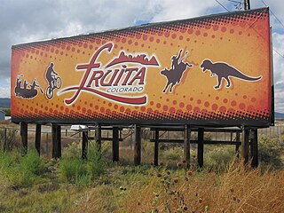
Fruita is a home rule municipality located in western Mesa County, Colorado, United States. The city population was 13,395 at the 2020 United States Census. Fruita is a part of the Grand Junction, CO Metropolitan Statistical Area and lies within the Grand Valley. The geography is identified by the bordering Colorado River on the southern edge of the town, the Uncompahgre Plateau known for its pinyon-juniper landscape, and the Book Cliffs range on the northern edge of the Grand Valley. Originally home to the Ute people, farmers settled the town after founder William Pabor in 1884. Ten years later, Fruita was incorporated.

Canmore is a town in Alberta, Canada, located approximately 81 kilometres (50 mi) west of Calgary near the southeast boundary of Banff National Park. It is located in the Bow Valley within Alberta's Rocky Mountains. The town shares a border with Kananaskis Country to the west and south and the Municipal District of Bighorn No. 8 to the north and east. With a population of 14,798 in 2020, Canmore is the ninth-largest town in Alberta.

Merritt is a city in the Nicola Valley of the south-central Interior of British Columbia, Canada. It is 270 km (170 mi) northeast of Vancouver. Situated at the confluence of the Nicola and Coldwater rivers, it is the first major community encountered after travelling along Phase One of the Coquihalla Highway and acts as the gateway to all other major highways to the B.C. Interior. The city developed in 1893 when part of the ranches owned by William Voght, Jesus Garcia, and John Charters were surveyed for a town site.

Topanga is an unincorporated community in western Los Angeles County, California, United States. Located in the Santa Monica Mountains, the community exists in Topanga Canyon and the surrounding hills. The narrow southern portion of Topanga at the coast is between the city of Malibu and the Los Angeles neighborhood of Pacific Palisades. As of the 2020 census the population of the Topanga CDP was 8,560. For statistical purposes, the United States Census Bureau has defined Topanga as a census-designated place (CDP). The ZIP code is 90290 and the area code is primarily 310, with 818 only at the north end of the canyon. It is in the 3rd County Supervisorial district.

Harrison Hot Springs is a village located at the southern end of Harrison Lake in the Fraser Valley of British Columbia. It is a member of the Fraser Valley Regional District; its immediate neighbour is the District of Kent, which includes the town of Agassiz. It is a resort community known for its hot springs and has a population of just over 1500 people. It is named after Benjamin Harrison, a former deputy governor for the Hudson's Bay Company.

Breaks Interstate Park, also known as "the Breaks," is a bi-state state park located partly in southeastern Kentucky and southwestern Virginia in the Jefferson National Forest, at the northeastern terminus of Pine Mountain. The land is managed by an interstate compact between the states of Virginia and Kentucky. It is the only one of two interstate parks in the United States operated jointly under a compact rather than as two separate state park units. The Virginia Department of Conservation and Recreation and the Kentucky Department of Parks are still major partner organizations.
A music festival is a community event with performances of singing and instrument playing that is often presented with a theme such as musical genre, nationality, locality of musicians, or holiday. Music festivals are generally organized by individuals or organizations within networks of music production, typically music scenes, the music industries, or institutions of music education.
Ninemile Canyon is a canyon, approximately 40 miles (64 km) long, located in Carbon and Duchesne counties in eastern Utah, United States. Promoted as "the world's longest art gallery", the canyon is known for its extensive rock art, most of it created by the Fremont culture and the Ute people. The rock art, shelters, and granaries left behind by the Fremont make Ninemile Canyon a destination for archaeologists and tourists alike.

Coso Rock Art District is a rock art site containing over 100,000 Petroglyphs by Paleo-Indians and/or Native Americans. The district is located near the towns of China Lake and Ridgecrest, California. Big and Little Petroglyph Canyons were declared a National Historic Landmark in 1964. In 2001, they were incorporated into this larger National Historic Landmark District. There are several other distinct canyons in the Coso Rock Art District besides the Big and Little Petroglyph Canyons. Also known as Little Petroglyph Canyon and Sand Tanks, Renegade Canyon is but one of several major canyons in the Coso Range, each hosting thousands of petroglyphs. The majority of the Coso Range images fall into one of six categories: bighorn sheep, entopic images, anthropomorphic or human-like figures, other animals, weapons & tools, and "medicine bag" images. Scholars have proposed a few potential interpretations of this rock art. The most prevalent of these interpretations is that they could have been used for rituals associated with hunting.

The Eastern Coachella Valley is located in Southern California. It is known to locals as a geographical subdivision of the Coachella Valley. In other words, although the Eastern Coachella Valley is located within the same Coachella Valley geographical parameters, it is considered its own. This subdivision is due primarily to the lack of incorporation of rural communities to the entity of the Coachella Valley as a whole.
Supercrawl is an annual art and indie music festival held each September in downtown Hamilton, Ontario.