Rocky Point, Prince Edward Island

Last updated
Canada Prince Edward Island location map 2.svg
Red pog.svg
Rocky Point
Location of Rocky Point in Prince Edward Island

Rocky Point is a settlement in Prince Edward Island. It is part of Lot 65 in Hillsboro Parish. Rocky Point had been the location of an annual Mi'kmaq summer coastal community prior to European settlement. [1]

Prince Edward Island Province of Canada

Prince Edward Island is a province of Canada consisting of the Atlantic island of the same name along with several much smaller islands nearby. PEI is one of the three Maritime Provinces. It is the smallest province of Canada in both land area and population, but it is the most densely populated. Part of the traditional lands of the Mi'kmaq, it became a British colony in the 1700s and was federated into Canada as a province in 1873. Its capital is Charlottetown. According to the 2016 census, the province of PEI has 142,907 residents.

Lot 65, Prince Edward Island Township in Prince Edward Island, Canada

Lot 65 is a township in Queens County, Prince Edward Island, Canada. It is part of Hillsboro Parish. Lot 65 was awarded to Richard Wright and Hugh Owens in the 1767 land lottery.

Hillsboro Parish, Prince Edward Island

Hillsboro Parish was created as a civil parish in Queens County, Prince Edward Island, Canada, during the 1764-1766 survey of Samuel Holland.

Port-la-Joye–Fort Amherst, a National Historic Site, is located within the settlement.

National Historic Sites of Canada site of national historic significance in Canada

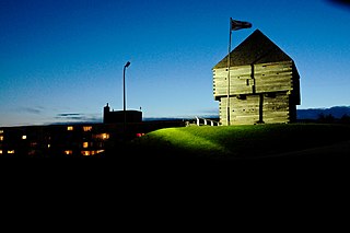
National Historic Sites of Canada are places that have been designated by the federal Minister of the Environment on the advice of the Historic Sites and Monuments Board of Canada (HSMBC), as being of national historic significance. Parks Canada, a federal agency, manages the National Historic Sites program. As of October 2018, there are 987 National Historic Sites, 171 of which are administered by Parks Canada; the remainder are administered or owned by other levels of government or private entities. The sites are located across all ten provinces and three territories, with two sites located in France.

Sources

  1. "Micmac Locations". Micmac Tribe. Access Genealogy. Retrieved 27 May 2014.

Coordinates: 46°12′14″N63°09′06″W / 46.203852°N 63.151574°W / 46.203852; -63.151574

Geographic coordinate system Coordinate system

A geographic coordinate system is a coordinate system that enables every location on Earth to be specified by a set of numbers, letters or symbols. The coordinates are often chosen such that one of the numbers represents a vertical position and two or three of the numbers represent a horizontal position; alternatively, a geographic position may be expressed in a combined three-dimensional Cartesian vector. A common choice of coordinates is latitude, longitude and elevation. To specify a location on a plane requires a map projection.


Related Research Articles

Groveland, New York Town in New York, United States

Groveland is a town in Livingston County, New York, United States. The population was 3,249 at the 2010 census.

Miꞌkmaq ethnic group

The Miꞌkmaq or Miꞌgmaq are a First Nations people indigenous to Canada's Atlantic Provinces and the Gaspé Peninsula of Quebec as well as the northeastern region of Maine. They call their national territory Miꞌkmaꞌki. The nation has a population of about 170,000, of whom nearly 11,000 speak Miꞌkmaq, an Eastern Algonquian language. Once written in Miꞌkmaq hieroglyphic writing, it is now written using most letters of the Latin alphabet.

Biscoe Point is a rocky point forming the south-eastern side of Biscoe Bay, immediately north of Access Point on the south side of Anvers Island, in the Palmer Archipelago of Antarctica.

Parks in Halifax, Nova Scotia

The Halifax Regional Municipality has a number of parks and recreation areas in urban and rural settings.

Miscouche rural municipality in Prince Edward Island

Miscouche is a municipality that holds community status in Prince Edward Island, Canada. It is located in Prince County.

Route 318 is a collector road in the Canadian province of Nova Scotia.

Shubie Park

Shubie Park is a 16-hectare (40-acre) urban park in Dartmouth, Nova Scotia maintained by the Halifax Regional Municipality.

Tracadie is a Canadian rural community in Queens County, Prince Edward Island. It is located southwest of Mount Stewart. The name Tracadie, which is of Mi'kmaq origin, means "ideal camping location" and is pronounced tǔlakǎdǐk.

West Royalty is a neighbourhood of the city of Charlottetown in central Queens County, Prince Edward Island, Canada.

Afton, Prince Edward Island rural municipality in Prince Edward Island

Afton is Canadian rural municipality located in Queens County, Prince Edward Island.

Cascapédia–Saint-Jules Municipality in Quebec, Canada

Cascapédia–Saint-Jules is a municipality in Quebec, Canada.

Rocky Point, Jamaica

Rocky Point is a settlement in Jamaica. It has a population of 3,183 as of 2009.

Battle of Winnepang

The Battle of Winnepang occurred during Dummer's War when New England forces attacked Mi'kmaq at present day Jeddore Harbour, Nova Scotia. The naval battle was part of a campaign ordered by Governor Richard Philipps to retrieve over 82 New England prisoners taken by the Mi'kmaq in fishing vessels off the coast of Nova Scotia. The New England force was led by Ensign John Bradstreet and fishing Captain John Elliot.

Marrak Point was the location and common name for a minor USAAF airfield on the west coast of Greenland. It was operational from 1942 to 1945.

The Aroostook Band of Micmac is a federally recognized tribe of Mi'kmaq people in Aroostook County, Maine. Their autonym is Ulustuk. Of the 28 bands of Mi'kmaq people, the Aroostook Band is the only one in the United States, and the Aroostook Band were the first non-US power to sign a treaty with the United States on July 6, 1776.

Rocky Point, Cowlitz County, Washington Unincorporated community in Washington

Rocky Point is an unincorporated community in Cowlitz County, Washington, north of the city of Kelso. Rocky Point is located directly north of Kelso along or near North Pacific Avenue. The Rocky Point community is part of the Kelso School District, a K-12 school district of nearly 5,000 students.

Rocky Point 3

Rocky Point 3 is a Mi'kmaq reserve located in Queens County, Prince Edward Island. In the 2016 Census, the reserve has 51 residents.

Presnakov Island Island in Antarctica

Presnakov Island is the 390 m long in southeast-northwest direction and 100 m wide rocky island lying off the west coast of Low Island in the South Shetland Islands, Antarctica.