
Bahia is one of the 26 states of Brazil, located in the Northeast Region of the country. It is the fourth-largest Brazilian state by population and the 5th-largest by area. Bahia's capital is the city of Salvador, on a spit of land separating the Bay of All Saints from the Atlantic. Once a monarchial stronghold dominated by agricultural, slaving, and ranching interests, Bahia is now a predominantly working-class industrial and agricultural state. The state is home to 7% of the Brazilian population and produces 4.2% of the country's GDP.

Juazeiro, formerly also known as Joazeiro, is a municipality in the state of Bahia, in the northeastern region of Brazil.
Serra Dourada is a municipality in the Brazilian state of Bahia. In 2020, the estimated population was 17,321.

Santa Rita de Cássia is a Brazilian municipality in the state of Bahia. In 2020 the town's population was estimated as 28,481 inhabitants.
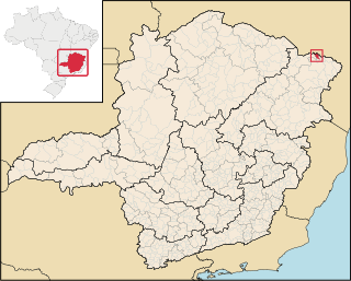
Mata Verde is a Brazilian municipality located in the state of Minas Gerais. As of 2020 the population was 8,644 and the area was 230 km2 (89 sq mi). The elevation is 865 m (2,838 ft).
The Galheirão River is a river of Bahia state in eastern Brazil.
The Sapão River is a river of Bahia state in eastern Brazil.
The São Desidério River is a river of Bahia state in eastern Brazil.
Pindobaçu is a municipality in the state of Bahia in the North-East region of Brazil.
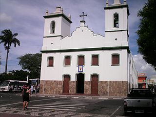
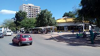
Senhor do Bonfim is a municipality in the state of Bahia in the North-East region of Brazil.

Maracás is a municipality in the state of Bahia in the North-East region of Brazil.
São Miguel das Matas is a municipality in the state of Bahia in the North-East region of Brazil.

Poções is a municipality in the state of Bahia in the North-East region of Brazil.
Castro Alves, Bahia is a municipality in the state of Bahia in the North-East region of Brazil. It was known as Vila de Nossa Senhora da Conceição de Curralinho, but it was rechristened Castro Alves in order to honor the poet who was born there.

Olindina is a municipality in the state of Bahia in the North-East region of Brazil.

Jaguaripe is a municipality in the state of Bahia in the North-East region of Brazil. It covers 863.424 km2 (333.370 sq mi), and has a population of 18,981 with a population density of 18.32 inhabitants per square kilometer. Jaguaripe is located 130 km (81 mi) from the state capital of Bahia, Salvador. Jaguaripe shares a border with the municipalities of Aratuípe, Nazaré, Maragogipe, Laje, São Miguel das Matas, and Santo Antônio de Jesus. It was the first municipality created outside of Salvador, dating to 1693.

Saubara is a municipality in the state of Bahia in the North-East region of Brazil.
Inhambupe is a municipality in the state of Bahia in the North-East region of Brazil.
Valente is a municipality in the state of Bahia in the North-East region of Brazil.

Carinhanha is a municipality in the state of Bahia in the North-East region of Brazil. Carinhanha covers 2,529.45 km2 (976.63 sq mi), and has a population of 29,070 with a population density of 12 inhabitants per square kilometer. It is located on the banks of the Rio São Francisco and the Carinhanha River, which also forms the border of the state of Minas Gerais.