Schaumburg is a district (Landkreis) of Lower Saxony, Germany. It is bounded by the districts of Nienburg, Hanover and Hameln-Pyrmont, and the state of North Rhine-Westphalia.

The Wiehen Hills are a hill range in North Rhine-Westphalia and Lower Saxony in Germany. The hills run from west to east like a long finger away from the main upland area of the Lower Saxon Hills, beginning at the Weser River near Minden and terminating in the vicinity of Osnabrück. It is the northernmost of the German Central Upland ranges extending into the Northern Lowlands. Their highest hill is the Heidbrink near Lübbecke with an altitude of 320 metres (1,050 ft).

Bad Münder is a town in the Hamelin-Pyrmont district, Lower Saxony, Germany. It is on the south side of the Deister hills in the Deister-Süntel valley, about 15 kilometres (9.3 mi) northeast of Hamelin. The city with 16 districts has about 17,400 inhabitants (2020). The district Bad Münder is the administrative centre with about 8,000 inhabitants.

Rodenberg is a town in the district of Schaumburg, in Lower Saxony, Germany. It is situated on the northwestern edge of the Deister hills, approx. 10 km east of Stadthagen, and 27 km west of Hanover.

Lauenau is a small town in Lower Saxony, Germany, with about 4,200 inhabitants. It is situated in the east of the district of Schaumburg just off the A2 Autobahn at the foot of the Deister ridge in the Deister-Süntel valley. As well as Lauenau itself, the parish includes the village of Feggendorf, a former coal mining community on the slopes of the Deister which now has a mining museum.
The Samtgemeinde Rodenberg is a collective municipality in Lower Saxony, Germany, of about 16,000 inhabitants. It is situated in the east of the district of Schaumburg at the slopes of the hills Deister and Süntel. Its seat is in the town of Rodenberg.

Apelern is a municipality in the Samtgemeinde of Rodenberg in the district of Schaumburg, in Lower Saxony, Germany. It lies in the Deister-Süntel valley and is situated close to the A2 Autobahn at Lauenau and south of Rodenberg, between the Deister, Süntel and Bückeberg ridges. The Riesbach stream flows through the village and into the Rodenberger Aue (stream).
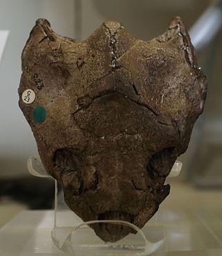
Dorsetochelys is an extinct genus of turtle from the Early Cretaceous of southern England and northwestern Germany.
The Calenberg Uplands are a landscape unit in the Weser-Leine Uplands in Lower Saxony, Germany. They border on the Calenberg Land to the north and merge into the Weser Uplands in the west and the Leine Uplands in the east. They are dissected by the Deister-Süntel and Aue valleys.

The Nesselberg is a ridge up to 378.2 m above sea level (NN) high in the Calenberg Highland which, together with the Kleiner Deister and the Osterwald, forms a group of three contiguous hill regions in the northwestern part of the Leine Uplands. It lies between Altenhagen I and Coppenbrügge in Lower Saxony, Germany.

The is a massif in the German Central Uplands that is up to 437.5 m above sea level (NN). It forms part of the Weser Uplands in Lower Saxony southwest of Hanover and north of Hamelin.

The Bückeberg is a small hill range, up to 375 metres (1,230 ft) high, in the Calenberg Uplands between the Harrl and the Deister in central Germany, and is often considered part of the Weser Uplands. It lies in the district of Schaumburg, and stretches for some 20 km (12 mi) from west to east from Bückeburg and the village of Bad Eilsen towards Bad Nenndorf.
The Kleiner Deister is a ridge of hills in the Calenberg Uplands which, together with the Nesselberg and the Osterwald, forms a group of three adjacent hill ranges in the northern part of the Leine Uplands. It lies between Springe and Eldagsen in Hanover region in Lower Saxony, Germany.

The Weser Uplands-Schaumburg-Hamelin Nature Park lies on the northern edge of the German Central Uplands where it transitions to the North German Plain, about 50 kilometres (31 mi) southwest of Hanover. The sponsor of the nature park, which was founded in 1975, is the state of Lower Saxony. The park extends along the Weser valley between Rinteln and Hamelin and includes parts of the Schaumburg Land, Calenberg, Lippe and Pyrmont Uplands from Bad Nenndorf in the north to Bad Pyrmont in the south, Bückeburg and Bad Eilsen in the west and Bad Münder and Osterwald in the east. Its highest elevation is in the Süntel hills.
The Deister-Süntel valley lies in the northeast Weser Uplands in the north German state of Lower Saxony between the ridges of the Bückeberg, Süntel and Deister in the districts of Schaumburg and Hameln-Pyrmont.

The Rehburg Hills are a hill range, up to 161.4 m above sea level (NN), in the districts of Nienburg and Schaumburg in Lower Saxony, Germany.

Hülsede Water Castle is a water castle in the Weser Renaissance style located in Hülsede in the German state of Lower Saxony between the Süntel and Deister ridges.
Hohe Egge is the name of the following hills in Germany:

