Karratha is a city in the Pilbara region of Western Australia, adjoining the port of Dampier. It was established in 1968 to accommodate the processing and exportation workforce of the Hamersley Iron mining company and, in the 1980s, the petroleum and liquefied natural gas operations of the North West Shelf Venture. As of the 2021 census, Karratha had an urban population of 17,013. The city's name comes from the cattle station of the same name, which derives from a word in a local Aboriginal language meaning "good country" or "soft earth". The city is the seat of government of the City of Karratha, a local government area covering the surrounding region.
Roebourne is a town in Western Australia's Pilbara region. In the Ngarluma language, Roebourne is called Yirramagardu (Ieramagadu). It is 35 km from Karratha, 202 km from Port Hedland and 1,563 km from Perth, the state's capital. It is located within the City of Karratha. It prospered during its gold boom of the late 19th century and was once the largest settlement between Darwin and Perth. At the 2016 census, Roebourne and the surrounding area had a population of 981.

The Electoral district of Roebourne was a Legislative Assembly electorate in the state of Western Australia. It was named for the town of Roebourne and was created in 1890, being one of the original 30 seats contested at the 1890 colonial election. In 1898, the boundaries of the district did not extend far beyond the settlements of Roebourne and Cossack.
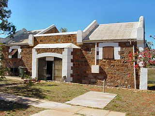
Cossack, known as Bajinhurrba in Ngarluma language, and formerly known as Tien Tsin, is an historic ghost town located 1,480 km (920 mi) north of Perth and 15 km (9.3 mi) from Roebourne in the Pilbara region of Western Australia. The nearest town to Cossack, which is located on Butcher Inlet at the mouth of the Harding River, is Wickham. The former Tien Tsin Harbour is now known as Port Walcott. Since 2021, the townsite is managed and operated by the Ngarluma and Yindjibarndi Foundation Ltd (NYFL).

The City of Karratha is one of the four local government areas in the Pilbara region of Western Australia. It covers an area of 15,882 square kilometres (6,132 sq mi) and had a population of about 21,500 as at the 2016 Census, most of which is located in its seat of government, the city of Karratha, and the major towns. It was formerly known as the Shire of Roebourne but was renamed and granted city status on 1 July 2014.
Karratha Airport is an airport in Karratha, in the Pilbara region of Western Australia. The airport is 14 km (8.7 mi) from Karratha and 5 nautical miles south of Dampier.
The Flying Foam Massacre was a massacre of Aboriginal people around Flying Foam Passage on Murujuga in Western Australia by colonial settlers. Comprising a series of atrocities between February and May 1868, the massacre was in retaliation to the killing of a police officer, a police assistant, and a local workman. Collectively the atrocities resulted in the deaths of an unknown number of Jaburara people, but with estimates ranging from 15 to 150 dead men, women and children.

The Harding River, known as the Ngurin in Ngarluma language, is a river in the Pilbara region of Western Australia. It was named on 31 July 1861 by the surveyor and explorer Francis Gregory while on expedition in the area, after one of the volunteer members of his expedition, John Harding. The river continues to be known as the Ngurin by traditional owners and local Aboriginal people.
The Angelo River is a river in the Pilbara region of Western Australia.
Sherlock Station is a pastoral lease and sheep station located approximately 54 kilometres (34 mi) East of Roebourne in the Pilbara region of Western Australia. Covering an area of 216,700 acres (87,695 ha) pasture, the lease provides good grazing land. In 2015 it was purchased by Bettini Bros, now Bettini Beef, in a package with Mallina and Pyramid Stations. The Bettinis still owned the lease in 2018. Sherlock is operating under the Crown Lease number CL311-1966 and has the Land Act number LA3114/558.
Pyramid Station is a pastoral lease and cattle station located approximately 100 kilometres (62 mi) east of Karratha in the Pilbara region of Western Australia. The station has also previously run sheep on its pastures.
Croydon Station, often spelt as Croyden Station, is a pastoral lease and sheep station.

The United States Penitentiary, Victorville is a high-security United States federal prison for male inmates in California. It is part of the Federal Correctional Complex, Victorville and is operated by the Federal Bureau of Prisons, a division of the United States Department of Justice.
The George River is a river in the Pilbara region of Western Australia. The river was named on 16 July 1861 by the surveyor and explorer Frank Gregory, who was conducting an expedition in the area. It is not known after whom he named the river.
Mount Welcome Station is a pastoral lease that once operated as a sheep station but is now operated as a cattle station in Western Australia.
Minderoo Station, commonly referred to as Minderoo, is a pastoral lease that once operated as a sheep station but now operates as a cattle station in Western Australia.
Main Roads Western Australia controls the major roads in the state's Pilbara region. There are two main highways in the region: Great Northern Highway, which travels north through the region to Port Hedland and then north-west along the coast, as well as North West Coastal Highway, which heads south-west from Port Hedland. A series of main roads connects towns to the highways, and local roads provide additional links. The majority of these roads service the western half of the region, with few located in the various deserts east of the Oakover River. Roads are often named after the towns or areas they connect.
First Contact is an Australian reality television documentary series that aired on SBS One, SBS Two and NITV. It documents the journey of six European Australians who are challenged over a period of 28 days about their pre-existing perceptions of Indigenous Australians.
The Yindjibarndi are an Aboriginal Australian people of the Pilbara region of Western Australia. They form the majority of Aboriginal people around Roebourne. Their traditional lands lie around the Fortescue River.
Millstream Station is a defunct pastoral lease that was once a sheep station and cattle station in Western Australia. The property is now part of Millstream Chichester National Park.
