
Kansas is a U.S. state in the Midwestern United States. Its capital is Topeka and its largest city is Wichita, with its most populated county and largest employment center being Johnson County. Kansas is bordered by Nebraska on the north; Missouri on the east; Oklahoma on the south; and Colorado on the west. Kansas is named after the Kansas River, which in turn was named after the Kansa Native Americans who lived along its banks. The tribe's name is often said to mean "people of the (south) wind" although this was probably not the term's original meaning. For thousands of years, what is now Kansas was home to numerous and diverse Native American tribes. Tribes in the eastern part of the state generally lived in villages along the river valleys. Tribes in the western part of the state were semi-nomadic and hunted large herds of bison.

Kansas City is the largest city in the U.S. state of Missouri by population and area. According to the U.S. Census Bureau, the city had an estimated population of 491,918 in 2018, making it the 38th most-populous city in the United States. It is the most populated municipality and historic core city of the Kansas City metropolitan area, which straddles the Kansas–Missouri state line and has a bi-state CSA population of 2,487,053. Most of the city lies within Jackson County, but portions spill into Clay, Cass, and Platte counties. The city borders Johnson County and Kansas City, Kansas, in Kansas. Kansas City was founded in the 1830s as a Missouri River port at its confluence with the Kansas River coming in from the west. On June 1, 1850, the town of Kansas was incorporated; shortly after came the establishment of the Kansas Territory. Confusion between the two ensued, and the name Kansas City was assigned to distinguish them soon after.
Rome is the English form of the name of the capital city of Italy, and formerly capital of the Roman Empire and seat of the papacy, where it consistently has been called Roma.

Wyandotte County is a county located in the U.S. state of Kansas. As of the 2010 census, the population was 157,505, making it the fourth-most populous county in Kansas. Its county seat and most populous city is Kansas City, with which it shares a unified government. Wyandotte County lies immediately north of Johnson County, Kansas and west of Kansas City, Missouri.

Sumner County is a county located in the U.S. state of Kansas. As of the 2010 census, the population was 24,132. Its county seat is Wellington.

Johnson County abbreviated as ’’JoCo’’ is the most populated county and largest employment center in Kansas. Johnson County is a suburb of Kansas City (MO). Its county seat is Olathe and its most populous city is Overland Park. Bordering Kansas City (MO) and Kansas City (KS), it has become the most densely populated county within the Kansas City Metropolitan Area. As of the 2010 census, the county population was 544,179 with a 2018 estimate of 597,555 making it the most populous county in Kansas. It is home to the headquarters of Garmin, Sprint Telecomunications, and AMC Theatres, with total employment in 2017 being 333,751.

Ellis County is a county located in the U.S. state of Kansas. As of the 2010 census, the county population was 28,452. Its county seat and most populous city is Hays.

Hays is a city in and the county seat of Ellis County, Kansas, United States. The largest city in northwestern Kansas, it is the economic and cultural center of the region. As of the 2010 census, the city population was 20,510. It is also a college town, home to Fort Hays State University.

Kansas City, abbreviated as "KCK", is the third-largest city in the State of Kansas, the county seat of Wyandotte County, and the third-largest city of the Kansas City metropolitan area. It is situated at Kaw Point, which is the junction of the Missouri and Kansas rivers. It borders Johnson County, Kansas to the south and Kansas City, Missouri (KCMO) to the east, after which Kansas City, Kansas, is named. It is part of a consolidated city-county government known as the "Unified Government". Wyandotte County also includes the independent cities of Bonner Springs, Edwardsville, a portion of Lake Quivira, and the unincorporated area known as Loring. As of the 2010 census, the city had a population of 145,786 residents.

The Kansas City metropolitan area is a bi-state 14-county metropolitan area straddling the border between the U.S. states of Missouri and Kansas, anchored by Jackson County, Missouri, and Johnson County, Kansas. Its most-populous municipality is Kansas City, Missouri (KCMO). With a population of 2,487,053, it ranks as the second-largest metropolitan area in Missouri and the largest metropolitan area in Kansas. Alongside KCMO, the area includes a number of other cities and suburbs, the largest being Overland Park, Kansas; Kansas City, Kansas; Olathe, Kansas; and Independence, Missouri; each over 100,000 in population. The Mid-America Regional Council (MARC) serves as the Council of Governments and the Metropolitan Planning Organization for the area.
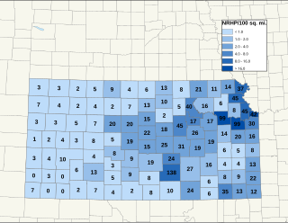
There are over 1,400 buildings, sites, districts, and objects in Kansas listed on the National Register of Historic Places in Kansas. NRHP listings appear in 101 of the state's 105 counties.
Stone Edward Johnson was an Olympic sprinter and American football kick returner and running back for the Kansas City Chiefs.

The Peoria Metropolitan Statistical Area, as defined by the United States Census Bureau, is an area consisting of five counties in Central Illinois, anchored by the city of Peoria. As of the 2010 census, the MSA had a population of 379,186. The City of Peoria, according to the estimated 2014 US Census Bureau, has 115,828 people.

The Kansas City Missouri Temple is the 137th operating temple of The Church of Jesus Christ of Latter-day Saints. It is the first to be built in the Greater Kansas City area. Previous attempts at building an LDS temple in the area failed in Independence in 1833 and Far West in 1838, after church founder Joseph Smith had selected and dedicated locations for their construction. A temple was completed in Independence in 1994 by the Community of Christ, which is not affiliated with the LDS Church.
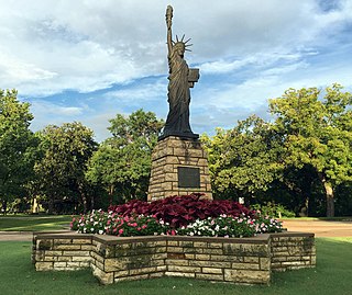
Strengthen the Arm of Liberty is the theme of the Boy Scouts of America's fortieth anniversary celebration in 1950. The campaign was inaugurated in February with a dramatic ceremony held at the base of the Statue of Liberty. Approximately 200 BSA Statue of Liberty replicas were installed across the United States.
James Patrick Keleher is an American prelate of the Roman Catholic Church. He served as Bishop of Belleville (1984–1993) and Archbishop of Kansas City (1993–2005).

Yocemento is an unincorporated community in Big Creek Township, Ellis County, Kansas, United States. The settlement lies across the banks of Big Creek where the seasonal stream meanders against the base of bluffs capped by massive limestone blocks, in which lies the 20th-century origin of the community.

Rome was a short-lived postbellum frontier settlement in Ellis County, Kansas, United States.

Rome is an unincorporated community in Sumner County, Kansas, United States. It is located about 6.5 miles south of Wellington at about 0.5 miles east of the intersection of U.S. Route 81 and E 90th St, next to the railroad.