Mount Chirripó is the highest mountain in Costa Rica with an elevation of 3,821 meters. It is located in Chirripó National Park and is noted for its ecological wealth. The mountain was named "Chirripo," meaning "land of eternal waters", by native Americans because there are many lakes and streams around the mountain. The high peaks in Chirripó National Park and La Amistad International Park host important areas of Talamancan montane forest and Costa Rican Páramo with high endemism and an extremely high biodiversity. The peaks of these mountains constitute sky islands for many species of plants and animals. Snow has not fallen on the peak in the past 100 years or so, according to the University of Costa Rica, but hail is sometimes reported.
National System of Conservation Areas or SINAC,, is part of the Ministry of Environment and Energy or MINAE of Costa Rica. It is the administrator for the nation's national parks, conservation areas, and other protected natural areas.

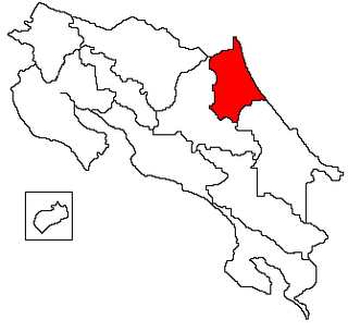
Arenal Huetar Norte Conservation Area is an administrative area which is managed by SINAC for the purposes of conservation in the northern part of Costa Rica. It contains a National Park, and number of Wildlife refuges and Forest Reserves. It has been proposed that the Maquenque National Park be formed in this area, which would incorporate some of the existing nature reserves and expand on them.
Corredor Fronterizo Wildlife Refuge is a Wildlife refuge, running through Arenal Huetar Norte, Guanacaste, Central Volcanic and Tortuguero Conservation Areas, in the northern part of Costa Rica running as a 2,000 metre wide strip of land along the border with Nicaragua. It was created in 1994, and there are no public facilities specifically for this refuge. The refuge contains a number of research programs of varying disciplines.

Laguna Las Camelias Wildlife Refuge, also the Camelias Lagoon National Wildlife Refuge, is a wildlife refuge that is part of the Arenal Huetar Norte Conservation Area, in the northern part of Costa Rica, near Upala in the Alajuela Province, close to the border with Nicaragua. It protects palustrine wetlands and forests which serve as a feeding and breeding ground for 240 species of birds, including the Muscovy duck and jabiru.

The Ostional Wildlife Refuge is a 85.7 km2 (33.1 sq mi) Wildlife refuge of Costa Rica, part of the Tempisque Conservation Area, was originally declared a protected area in 1982, and its status has been changed several times since then, including covering a larger area both on land and out to sea. It was created to protect important nesting beaches of the Olive ridley sea turtle.

The Cueva Murciélago Wildlife Refuge is a wildlife refuge of Costa Rica, part of the Tempisque Conservation Area, and protects tropical forest in the coastal areas of the southern Nicoya Peninsula near Cabuya.

The Nicoya Peninsula is a peninsula on the Pacific coast of Costa Rica. It is divided into two provinces: Guanacaste Province in the north, and the Puntarenas Province in the south. It is located at 10°N 85.4166667°W. It varies from 19 to 37 miles (60 km) wide and is approximately 75 miles (121 km) long, forming the largest peninsula in the country. It is known for its beaches and is a popular tourist destination.
The Tamarindo Wildlife Refuge is a wildlife refuge of Costa Rica, part of the Tempisque Conservation Area, protects the estuary and river mouth of the Matapalo River near the Las Baulas National Marine Park.

Tortuguero Conservation Area is an administrative area which is managed by SINAC for the purposes of conservation in Limón Province, northeastern Costa Rica.

Dr. Archie Carr Wildlife Refuge is a wildlife refuge located within the Tortuguero Conservation Area, in the Limón Province of northeastern Costa Rica. The refuge is located north of the village of Tortuguero, between the Barra del Colorado Wildlife Refuge and the Tortuguero National Park. It is named after Dr. Archie Carr, who set up the Caribbean Conservation Corporation in the same area in 1955.

Junquillal Bay Wildlife Refuge, also called the Bahia Junquillal National Wildlife Refuge, is a 4.38 km2 (1.69 sq mi) wildlife refuge in Guanacaste Province of northwestern Costa Rica.

Arenal Tilaran Conservation Area is an administrative area which is managed by SINAC for the purposes of conservation in the central part of Costa Rica, near the Arenal Volcano and covering the Cordillera de Tilarán. It contains a number of National Parks, Wildlife refuges and Protected Zones.

Central Pacific Conservation Area is an administrative area which is managed by SINAC for the purposes of conservation in the southwestern part of Costa Rica, on the Pacific coast. It contains four National Parks, and a number Wildlife refuges and other types of nature reserve.

Caribbean La Amistad Conservation Area is an administrative area which is managed by SINAC for the purposes of conservation in the eastern part of Costa Rica, on the Caribbean coast. It contains several national parks, and a number wildlife refuges and other types of nature reserve.

Pacific La Amistad Conservation Area is an administrative area which is managed by SINAC for the purposes of conservation in the southern part of Costa Rica, on the Pacific side of the Continental Divide. It contains several National Parks, and a number Wildlife refuges and other types of nature reserve.

Osa Conservation Area is an administrative area which is managed by SINAC for the purposes of conservation in Costa Rica, on the southern Pacific coast region. It contains two National Parks, and numerous Wildlife refuges and other types of nature reserve.

Central Volcanic Conservation Area is an administrative area which is managed by SINAC for the purposes of conservation in the central part of Costa Rica, notably the volcanic areas of the Cordillera Central. It contains four National Parks, and a number Wildlife refuges and other types of nature reserve.
Manzanillo is a village located inside the Gandoca-Manzanillo Wildlife and Marine Refuge. Manzanillo is situated south of Puerto Limon in Limón Province on Costa Rica’s Caribbean coast. The main attraction of this tiny town is its white sand beach lined with palm trees.


