
Greenbelt is a city in Prince George's County, Maryland, United States, and a suburb of Washington, D.C. Per the 2020 census, the population was 24,921.

Wauwatosa is a city in Milwaukee County, Wisconsin, United States. The population was 48,387 at the 2020 census. Wauwatosa is located immediately west of Milwaukee, and is a part of the Milwaukee metropolitan area. It is named after the Potawatomi Chief Wauwataesie and the Potawatomi word for firefly.

The Franklin Delano Roosevelt Memorial is a presidential memorial in Washington D.C., dedicated to the memory of Franklin Delano Roosevelt, the 32nd President of the United States, and to the era he represents. The memorial is the second of two that have been constructed in Washington to commemorate that president.

The Near South Side is a community area of Chicago, Illinois, United States, just south of the downtown central business district, the Loop. The Near South Side's boundaries are as follows: North—Roosevelt Road ; South—26th Street; West—Chicago River between Roosevelt and 18th Street, Clark Street between 18th Street and Cermak Road, Federal between Cermak Road and the Stevenson Expressway just south of 25th Street, and Clark Street again between the Stevenson and 26th Street; and East—Lake Michigan.

Petworth is a residential neighborhood in the Northwest quadrant of Washington, D.C. It is bounded to the east by the Armed Forces Retirement Home and Rock Creek Cemetery, to the west by Arkansas Avenue NW, to the south by Rock Creek Church Road NW and Spring Road NW, and to the north by Kennedy Street NW.
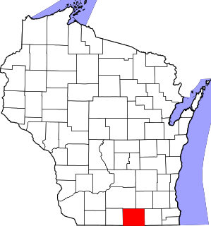
This is a list of the National Register of Historic Places listings in Rock County, Wisconsin. It is intended to provide a comprehensive listing of entries in the National Register of Historic Places that are located in Rock County, Wisconsin. The locations of National Register properties for which the latitude and longitude coordinates are included below may be seen in a map.

This is a list of the National Register of Historic Places listings in Waukesha County, Wisconsin. It is intended to provide a comprehensive listing of entries in the National Register of Historic Places that are located in Waukesha County, Wisconsin. The locations of National Register properties for which the latitude and longitude coordinates are included below may be seen in a map.

Tenley Circle is a traffic circle in the Northwest Washington, D.C. neighborhood of Tenleytown. Tenley Circle lies at the intersection of Nebraska Avenue, Wisconsin Avenue, and Yuma Street. Unlike many of the circles in Washington, Tenley's traffic pattern has evolved such that the dominant roadway, Wisconsin Avenue, can pass straight through the center instead of going around the outside circumference.

This is a list of the National Register of Historic Places listings in Brown County, Wisconsin. It is intended to provide a comprehensive listing of entries in the National Register of Historic Places that are located in Brown County, Wisconsin. The locations of National Register properties for which the latitude and longitude coordinates are included below may be seen in a map.

This is a list of the National Register of Historic Places listings in Eau Claire County, Wisconsin. It is intended to provide a comprehensive listing of entries in the National Register of Historic Places that are located in Eau Claire County, Wisconsin. The locations of National Register properties for which the latitude and longitude coordinates are included below may be seen in a map.

This is a list of the National Register of Historic Places listings in Grant County, Wisconsin. It is intended to provide a comprehensive listing of entries in the National Register of Historic Places that are located in Grant County, Wisconsin. The locations of National Register properties for which the latitude and longitude coordinates are included below may be seen in a map.

This is a list of the National Register of Historic Places listings in La Crosse County, Wisconsin. It is intended to provide a comprehensive listing of entries in the National Register of Historic Places that are located in La Crosse County, Wisconsin. The locations of National Register properties for which the latitude and longitude coordinates are included below may be seen in a map.

This is a list of the National Register of Historic Places listings in Outagamie County, Wisconsin. It is intended to provide a comprehensive listing of entries in the National Register of Historic Places that are located in Outagamie County, Wisconsin. The locations of National Register properties for which the latitude and longitude coordinates are included below may be seen in a map.

This is a list of the National Register of Historic Places listings in Ashland County, Wisconsin. It is intended to provide a comprehensive listing of entries in the National Register of Historic Places that are located in Ashland County, Wisconsin. The locations of National Register properties for which the latitude and longitude coordinates are included below may be seen in a map.
This list comprises buildings, sites, structures, districts, and objects in the City of Milwaukee, Wisconsin, which are listed on the National Register of Historic Places. There are 278 NRHP sites listed in Milwaukee County, including 72 outside the City of Milwaukee included in the National Register of Historic Places listings in Milwaukee County, Wisconsin and 206 in the city, listed below. One previously listed site in the city has been removed.

This is a list of the National Register of Historic Places listings in Wood County, Wisconsin. It is intended to provide a comprehensive listing of entries in the National Register of Historic Places that are located in Wood County, Wisconsin. The locations of National Register properties for which the latitude and longitude coordinates are included below may be seen in a map.

The Bayley Avenue Historic District is located in Platteville, Wisconsin. It was added to the National Register of Historic Places in 2007.

The Greendale Historic District is a National Historic Landmark District encompassing the historic core of the village of Greendale, Wisconsin. The village core was designed in the 1930s as part of a New Deal program to establish so-called "greenbelt towns" as model suburbs, and is one of three such communities built by the federal government. It was added to the National Register of Historic Places in 2005 and designated as a National Historic Landmark in 2012.

Van Ryn & DeGelleke was an architectural firm in Wisconsin. It was a partnership of Henry J. Van Ryn and Gerrit Jacob DeGelleke, both of whom grew up in Milwaukee.
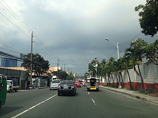
Fernando Poe Jr. Avenue is the principal north–south tertiary road serving the San Francisco del Monte district of Quezon City, Philippines. It runs with a length of 2.871 kilometers (1.784 mi) between Epifanio de los Santos Avenue (EDSA) to the north and Quezon Avenue to the south. The avenue is named after Fernando Poe Jr., a renowned actor and National Artist of the Philippines. As Roosevelt Avenue, it was named after United States president Franklin D. Roosevelt.
