
Santa Ana is a small city and municipal seat of Santa Ana Municipality in the Mexican state of Sonora. It is located 168 kilometres (104 mi) north of the state capital Hermosillo and 100 kilometres (62 mi) south of Nogales on the United States border. The town had a 2005 census population of 10,593 inhabitants.
Imuris is the municipal seat of Imuris Municipality in the north of the Mexican state of Sonora.
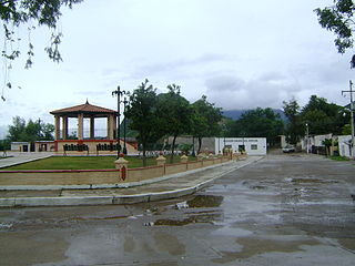
Arivechi is a town in the Mexican state of Sonora. It serves as the municipal seat of the surrounding municipality of the same name.
Bacanora is a small town in Bacanora Municipality in the east of the Mexican state of Sonora. It is located at the geographical coordinates of 28°59′N109°24′W.

Bacoachi is a small town in Bacoachi Municipality in the north of the Mexican state of Sonora. The area of the municipality is 487 square miles (1,260.65 km2) and the population was 1,456 in 2005, with 924 inhabitants residing in the municipal seat. The elevation of the municipal seat is 4,429 feet above sea level.
Huásabas is the municipal seat of Huásabas Municipality in the northeast of the Mexican state of Sonora. The municipal area is 711.17 km² (274.58 mi²) with a population of 966 registered in 2000. Most of the inhabitants live in the municipal seat.
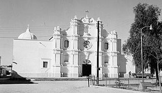
San Felipe de Jesús is the municipal seat of San Felipe de Jesús Municipality in the center of the Mexican state of Sonora. It is named after Mexico's first saint and Franciscan martyr, Saint Philip of Jesus.
Moctezuma is a municipio (municipality) of the Mexican state of Sonora, located in the state's central region. It is also the name of its largest settlement and cabecera municipal.

Nacozari de García is a small mining town in the northeast of the Mexican state of Sonora. It serves as the municipal seat for the surrounding municipality of the same name.

Ónavas is a small town surrounded by Onavas Municipality in the southeast of the Mexican state of Sonora.

Pitiquito is a small town in Pitiquito Municipality in the northwest of the Mexican state of Sonora.
Tepache is a small town in Tepache Municipality in the east of the Mexican state of Sonora. Its location by GPS coordinates is at: Longitude (dec): -109.528889; Latitude (dec): 29.533333.

Quiriego is a small town and the county seat of the Municipality of Quiriego, located in the southeast of the Mexican state of Sonora.
Rayón is a small town surrounded by its municipal area in the center of the Mexican state of Sonora at a distance of 110 kilometers from the state capital Hermosillo.

Yécora is a small town, and its surrounding municipality of the same name, in the Mexican state of Sonora. An approximate population for Yécora is 3171.
Soyopa is a town in Soyopa Municipality, in the eastern region of the Mexican state of Sonora. The elevation is 350 meters.
Suaqui Grande is a town in Suaqui Grande Municipality, in the eastern region of the Mexican state of Sonora. It was founded in 1620 by the Jesuit missionary Martín Burgencio as San Ignacio de Suaqui.

Navojoa is a municipality in the state of Sonora in north-western Mexico. As of 2015, the municipality had a total population of 163,650. The municipal seat is the city of Navojoa.

Quiriego is a municipality in the southern part of the Mexican state of Sonora.
Rosario de Tesopaco is a municipality in Sonora in north-western Mexico. The municipal seat is at Rosario de Tesopaco.