This article needs additional citations for verification .(May 2020) (Learn how and when to remove this template message) |
Roscore is a townland in County Offaly, Ireland. It is located to the north of Blue Ball. [1]
This article needs additional citations for verification .(May 2020) (Learn how and when to remove this template message) |
Roscore is a townland in County Offaly, Ireland. It is located to the north of Blue Ball. [1]
Newtown may refer to:
Ballynahinch is the name of a number of places in Ireland:

The R400 road is a regional road in Ireland, linking Mullingar, County Westmeath to the R419 at Cushina, County Offaly.
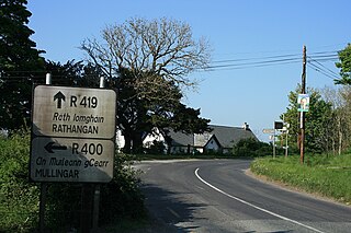
Cushina is a townland in County Offaly on the Cushina River at the junction of the R400 and R419 regional roads.
Derrymullan, also Derrymullen, is a 226-acre townland on the north side of Ballinasloe in County Galway, Ireland. It is in the barony of Clonmacnowen and the civil parish of Kilcloony.
Ikerrin is a barony in County Tipperary, Ireland. This geographical unit of land is one of 12 baronies in County Tipperary. Its chief town is Roscrea. The barony lies between Eliogarty to the south and Ormond Upper to the west. As a "peninsula", it is surrounded on three sides by counties Offaly and Laois. The territory is currently administered by Tipperary County Council.
Tully may refer to:
Monsea is a townland in the Barony of Ormond Lower. It is also a civil parish in the Baronies of Ormond Lower and Owney and Arra in County Tipperary, Ireland. Nine of the townlands within the civil parish are located in Ormond Lower with three townlands located in Owney and Arra.
Lusmagh GAA is a Gaelic Athletic Association club located in the townland of Lusmagh, County Offaly, Ireland. The club is almost exclusively concerned with the game of hurling.
Drumcullen GAA is a Gaelic Athletic Association club located in the townland of Drumcullen, County Offaly, Ireland. The club is almost exclusively concerned with the game of hurling.

Clonlonan is a barony in south–west County Westmeath, Ireland. It was formed by 1672. It is bordered by County Offaly to the south and a small part of County Roscommon at Long Island on the River Shannon to the west. It also borders four other Westmeath baronies: Kilkenny West and Rathconrath, Moycashel and Brawny. The largest centre of population in the barony is the town of Moate.
Fartullagh, previously Tyrrells country, is a barony in south–east County Westmeath, in the Republic of Ireland. It was formed by 1542. It is bordered by County Offaly to the south and three other baronies: Moycashel, Moyashel and Magheradernon and Farbill.

Castlelost is a civil parish in County Westmeath, Ireland. It is located about 12.81 kilometres (8 mi) south of Mullingar.
Kilcumreragh is a civil parish which spans the counties of Westmeath and Offaly in Ireland. It is located about 23.23 kilometres (14 mi) west–south–west of Mullingar and 18.28 kilometres (11 mi) north–north–west of Tullamore.
Durrow is a civil parish in County Offaly, Ireland. It is located about 5.52 kilometres (3 mi) north–north–west of Tullamore.
Ardnurcher is a civil parish in County Westmeath, Ireland. It is located about 19.89 kilometres (12 mi) south–west of Mullingar.
Ardnurcher is a civil parish in County Offaly, Ireland. It is located about 13.74 kilometres (9 mi) north–north–west of Tullamore.
Kilmanaghan is a civil parish which spans the counties of Offaly and Westmeath in Ireland. It is located about 27.76 kilometres (17 mi) south–west of Mullingar and 17.52 kilometres (11 mi) north–west of Tullamore.
Drumman is a townland in Milltownpass in County Westmeath, Ireland. The townland is in the civil parish of Pass of Kilbride and is on the border with County Offaly. The M6 Motorway cuts through the middle of the townland, and the R446 regional road forms the northern border with the townlands of Milltown and Corcloon. The village of Milltownpass is located to the east of the townland, with Rochfortbridge to the west.
| This article related to the geography of County Offaly, Ireland is a stub. You can help Wikipedia by expanding it. |