
Lake Michigan is one of the five Great Lakes of North America. It is the second-largest of the Great Lakes by volume and the third-largest by surface area, after Lake Superior and Lake Huron. To the east, its basin is conjoined with that of Lake Huron through the 3+1⁄2-mile (5.6-kilometer) wide, 295-foot deep Straits of Mackinac, giving it the same surface elevation as its easterly counterpart; the two are geologically a single lake.
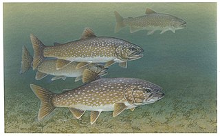
The lake trout is a freshwater char living mainly in lakes in northern North America. Other names for it include mackinaw, namaycush,lake char (or charr), touladi, togue, and grey trout. In Lake Superior, it can also be variously known as siscowet, paperbelly and lean. The lake trout is prized both as a game fish and as a food fish. Those caught with dark coloration may be called mud hens.

Camas is a city in Clark County, Washington, with a population of 26,065 at the 2020 census. The east side of town borders the city of Washougal, Washington, and the west side of town borders Vancouver, Washington. Camas lies along the Washington side of the Columbia River, across from Troutdale, Oregon, and is part of the Portland metropolitan area.

Lacamas Lake is a small lake in Clark County, Washington. It is a popular place to fish and water ski for locals from Vancouver, Camas and Washougal. It connects to Round Lake via a channel that runs under the SR 500 bridge on the southeast side of the lake. In the 1990s many high tech manufacturing plants and expensive housing developments began to appear in the area around the lake. The lake is very warm compared to other lakes in the area and the temperature can drop off quickly with depth. As it is now, the 60-foot-deep (18 m) lake cannot support life below about 18 ft (5.5 m). The Georgia-Pacific Mill in Camas used to draw water from the lake to support its operations; however, Georgia-Pacific donated the two dams on Round Lake to the City of Camas in 2018.

The Cache la Poudre River, also known as the Poudre River, is a river in the state of Colorado in the United States.

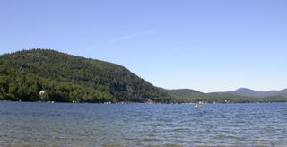
Otsego Lake is a 4,046-acre (16.37 km2) lake located in Otsego County in the U.S. state of New York. It is the source of the Susquehanna River and largest lake in Otsego County. The Village of Cooperstown is located at the lake's southern end. Glimmerglass State Park is located on the lake's northeastern shore, and includes Hyde Hall, a large mansion constructed in 1817, that overlooks the lake. The Glimmerglass Opera, opened in June 1987, is located on the western shore.

Donner Lake, formerly known as Truckee Lake, is a freshwater lake in Northeast California on the eastern slope of the Sierra Nevada and about 20 miles (32 km) northwest of the much larger Lake Tahoe. A moraine serves as a natural dam for the lake. The lake is located in the town of Truckee, between Interstate 80 to the north and Schallenberger Ridge to the south. The tracks of the Union Pacific Railroad run along Schallenberger Ridge and closely follow the route of the original transcontinental railroad. The historic route of the Lincoln Highway, the first automobile road across America and US 40 follows the northern shoreline, then climbs to Donner Pass from where the entire lake may be viewed.

Silver Lake, formerly known as Long Pond, is a small lake in the town of Hollis, New Hampshire, United States. The lake was formerly surrounded by summer vacation cottages and camps, but most of these buildings have now been converted for use as year-round homes. Silver Lake State Park occupies the northern end of the lakeshore.

Higgins Lake is a large recreational and fishing lake in Roscommon County, in the U.S. state of Michigan. The 9,900 acres (4,000 ha) lake is known for its deep, clear waters and is the 10th largest in Michigan with a shoreline of 21 miles (34 km). It is named after Sylvester Higgins, the first chief of the topographical department of the Michigan Geological Survey. It has a maximum width of 4 miles (6.4 km) and a length of 7 miles (11 km) with a maximum depth of 135 feet (41 m). The mean depth is 135 feet (41 m) and the lake contains almost 20 billion cubic feet of water. Its retention time is about 12.5 years. The lake's watershed covers 19,000 acres (7,700 ha). The twin-lobed lake receives half of its water from submerged springs, six percent from incoming streams, and the remainder from direct rainfall and runoff. It drains into Marl Lake by the Cut River which runs into Houghton Lake and eventually to Lake Michigan via the Muskegon River. A mile north of the lake, water flows into the Lake Huron watershed.
Newfound Lake is located in Grafton County, New Hampshire, United States. It is situated in the Lakes Region of central New Hampshire, in the towns of Alexandria, Bridgewater, Bristol, and Hebron. Its area of 4,451 acres (18.0 km2) places it behind only Lake Winnipesaukee and Squam Lake among lakes located entirely within New Hampshire, and fourth in the state overall, when Umbagog Lake on the Maine border is included.
Lake Winnisquam is in Belknap County in the Lakes Region of central New Hampshire, United States, in the communities of Meredith, Laconia, Sanbornton, Belmont, and Tilton. At 4,214 acres (1,705 ha), it is the fourth-largest lake entirely in New Hampshire. The lake is roughly triangular in shape, with the vertexes pointing north, east, and south. The lake lies along the path of the Winnipesaukee River, which enters the lake from its eastern corner and carries water from Lake Winnipesaukee via Paugus Bay and Opechee Bay. The river also flows south out of Winnisquam's southern corner, eventually joining the Merrimack River. The lake extends several miles north from the course of the Winnipesaukee River, which forms the lake's southeastern side, with the northern point being formed by the confluence of several smaller creeks near the village of Meredith Center. The lake has a maximum depth of 155 feet (47 m).

Bow Valley Provincial Park is a provincial park in Alberta, Canada. Established in 1959 in the arch of the Bow River at its confluence with the Kananaskis River, the park is one park of many within the Kananaskis Country park system.

Killarney Provincial Park is a provincial park in central Ontario, Canada.

Lacamas Creek is in Clark County, Washington, United States, and flows about 12.5 miles (20.1 km) from headwaters near Camp Bonneville to Lacamas Lake and Round Lake in Camas, and eventually into the Washougal River. Its name is derived from that of the native camas plant. Lacamas Creek is fed by numerous streams, but the five largest tributaries are Matney Creek, Shanghai Creek, Fifth Plain Creek, China Ditch, and Dwyer Creek.

The Prineville Reservoir is in the high desert hills of Central Oregon, Oregon, United States. The reservoir is on the Crooked River 14 miles (22.5 km) southeast of Prineville, and 29 miles (46.7 km) east of Bend. This reservoir is a popular retreat for most of Central Oregon. It is near the geographic center of Oregon. Prineville Reservoir State Park is managed by the Oregon Parks and Recreation Department.

Lake Sunapee is located within Sullivan County and Merrimack County in western New Hampshire, the United States. It is the fifth-largest lake located entirely in New Hampshire.

Camanche Reservoir is an artificial lake in the San Joaquin Valley in California in the United States, at the juncture of Amador, Calaveras, and San Joaquin counties. Its waters are impounded by Camanche Dam, which was completed in 1963. Camanche Reservoir is a source of water for industrial and municipal purposes and also provides flood control.

Lake Cobbosseecontee, also known as Cobbossee Lake, is a lake located in the towns of Litchfield, Manchester, Monmouth, West Gardiner, and Winthrop in the U.S. state of Maine. It is the largest lake in the Winthrop Lakes Region at 100 feet (30 m) deep, covering about 8.7 square miles (23 km2) in surface area, a length of 9 miles (14 km), and a shoreline of 62 miles (100 km). The word Cobbosseecontee translates to "plenty of sturgeon" in Wabanaki.

The Bennington Fish Hatchery, also known as the Bennington Fish Culture Station, is a state-operated fish hatchery at 110 Hatchery Road in Bennington, Vermont, USA. The station, the state's largest, produces a variety of trout, which are used to stock the state's water resources. Its facilities, dating to 1916, are listed on the National Register of Historic Places. The station has a visitors' center that is open daily.
East Kill, a 16-mile-long (26 km) tributary of Schoharie Creek, flows across the town of Jewett, New York, United States, from its source on Stoppel Point. Ultimately its waters reach the Hudson River via the Mohawk. Since it drains into the Schoharie upstream of Schoharie Reservoir, it is part of the New York City water supply system. East Kill drains the southern slopes of the Blackhead Mountains, which include Thomas Cole Mountain, Black Dome, and Blackhead Mountain, the fourth-, third-, and fifth-highest peaks in the Catskills, respectively.


