
Oman is a country on the southeast coast of the Arabian Peninsula, situated in West Asia, bordering the Arabian Sea, Gulf of Oman, and Persian Gulf, between Yemen and the United Arab Emirates (UAE). The coast of Oman was an important part in the Omani empire and sultanate.
This article is about transport in Oman.

The A6 is one of the main north–south roads in England. It runs from Luton in Bedfordshire to Carlisle in Cumbria, although it formerly started at a junction with the A1 at Barnet in north London, and is described as running from London to Carlisle.

The A31 is a major trunk road in southern England that runs from Guildford in Surrey to Bere Regis in Dorset. Its best-known section is the Hog's Back, a ridge forming part of the North Downs between Guildford and Farnham in Surrey.
The Omani territory of Madha or Wādī Madḥāʾ is an exclave of the Musandam Governorate, enclaved by the United Arab Emirates (UAE); inside it, there is a second-order enclave: Nahwa, which is part of the UAE Emirate of Sharjah. Madha is located halfway between the Musandam Peninsula and the rest of Oman.

Kumzari is a Southwestern Iranian language that is similar to the Persian, Achomi and Luri languages. Although vulnerable, it survives today with between 4,000 and 5,000 speakers. It is spoken by Kumzaris on the Kumzar coast of Musandam Peninsula as well as the Shihuh in the United Arab Emirates. Kumzari speakers can also be found in the towns of Dibba and Khasab as well as various villages, and on Larak Island.

E 11 is a highway in the United Arab Emirates (UAE). The longest road in the Emirates, it stretches from the Al Batha border crossing at the Saudi Arabia–UAE border in al-Silah in the al-Dhafra region of the Emirate of Abu Dhabi and ends at the Oman–UAE border crossing of al-Darah in al-Jeer, Emirate of Ras al-Khaimah, running roughly parallel to UAE's coastline along the Persian Gulf. The road forms the main artery in some emirates' main cities, where it assumes various alternate names —Sheikh Maktoum Bin Rashid Road and Sheikh Khalifa bin Zayed Road in Abu Dhabi, Sheikh Zayed Road in Dubai, Al Ittihad Road in Sharjah Emirate and Ajman Emirate, and Sheikh Muhammad bin Salem Road in Ras al-Khaimah.

Dibbā is a coastal area at the northern tip of the eastern Arabian Peninsula on the Gulf of Oman.

Khasab is a town and local capital of the Musandam Governorate which is an exclave of Oman bordering the United Arab Emirates at the tip of the Musandam Peninsula by the Strait of Hormuz. It has been dubbed the "Norway of Arabia" because of its extensive fjord-like craggy inlets and desolate mountainscapes.

The Musandam Governorate is a governorate of Oman. With the exception of the exclave of Madha, it is located on the Musandam Peninsula, which juts into the Strait of Hormuz, the narrow entry into the Persian Gulf, from the Arabian Peninsula. The governorate is also an exclave, separated from the rest of Oman by the United Arab Emirates. Its location gives Oman partial control, shared with Iran, of the strategic strait. In the northern section of Musandam, around Kumzar, the language is Kumzari, which is a southwestern Iranian language closely related to Larestani and Luri. The Musandam Peninsula has an area of 1,800 km2 (690 sq mi) and, at the 2020 census, a population of 49,062.

The Musandam Peninsula, locally known as Ruus Al Jibal, is a peninsula that forms the northeastern point of the Arabian Peninsula.

The N71 road is a national secondary road traversing counties Cork and Kerry in Ireland. Towns and villages along the route, westward from Cork city, include Innishannon, Bandon, Clonakilty, Skibbereen, Bantry and Glengarriff in County Cork. Continuing westwards from Glengarriff into County Kerry, the route passes Kenmare and terminates at Killarney.

Bukhāʾ is a Wilayat and town in the Muhafazah of Musandam in the Sultanate of Oman. It is located in the southwestern side of Musandam, overlooking the Persian Gulf. It is bordered to the east by the Wilayat of Khasab and borders the United Arab Emirates. Its population centers are about 22 localities, including Bukha, Al-Jadi, Ghumda, and Al-Jeri.

The City of Peterborough in East Anglia has an extensive and well integrated road network, owing partly to its status as a new town. Since the 1960s, the city has seen considerable expansion and its various suburbs are linked by a system of parkways.
Dibbā Al-Bayʿah is geographically part of the Dibba region that faces the Arabian Sea, and is bordered by the United Arab Emirates to the south. It is a Wilayat in the Muhafazah of Musandam, Sultanate of Oman, on the east coast of the Arabian Peninsula.It is considered one of the most famous Omani cities known in the pre-Islamic days because it contains Dibba market, which is one of the most famous Arab markets that was known at that time, as merchants from different countries around the world such as India, Sindh and China used to come to it, and some historians, such as Al-Asmai, attribute this name to the locusts Creeping to express the large number of people in it, and the area of that city is approximately 37 km2.
Shinas is a catamaran ferry in service on the Shinas–Khasab route in Oman, reportedly the fastest diesel ferry in the world. The route connects Musandam Governorate, an exclave of Oman at the tip of the Musandam peninsula, to Oman proper, without crossing through United Arab Emirates like the overland route.
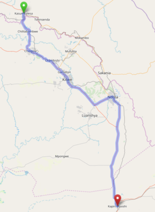
The T3 is a trunk road in Zambia. The road runs from Kapiri Mposhi via Ndola, Kitwe and Chingola to Kasumbalesa on the border with DR Congo. The entire route is a toll road.
Route 3 also known as Aswad Road is a route in the Sultanate of Oman. It is a dual carriageway that crosses through two governorates and goes from the city of Bu Baqarah all the way to the border with the United Arab Emirates.
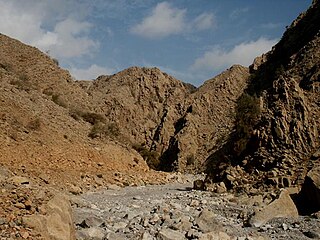
The Wadi Khabb Shamsi, is a valley or dry river, with ephemeral or intermittent flow, flowing almost exclusively during the rainy season, located west of the Musandam Governorate, in the Sultanate of Oman.


