
Amber Valley is a local government district with borough status in the east of Derbyshire, England, taking its name from the River Amber. Its council is based in Ripley. The district covers a semi-rural area lying to the north of the city of Derby. The district contains four main towns whose economy was based on coal mining and remains to some extent influenced by engineering, distribution and manufacturing, holding for instance the headquarters and production site of Thorntons confectionery.

Derbyshire Dales is a local government district in Derbyshire, England. The district was created in 1974 as West Derbyshire; the name was changed to Derbyshire Dales in 1987. The council is based in the town of Matlock, and the district also includes the towns of Ashbourne, Bakewell, Darley Dale and Wirksworth, as well as numerous villages and extensive rural areas. Much of the district is within the Peak District National Park.

North East Derbyshire is a local government district in Derbyshire, England. The council is based in the large village of Wingerworth. The district also includes the towns of Dronfield and Clay Cross as well as numerous villages and surrounding rural areas.

Bonsall is a village and civil parish in the Derbyshire Dales on the edge of the Peak District. The civil parish population, including Brightgate and Horse Dale, was 775 at the 2001 Census, increasing to 803 at the 2011 Census.

Gleadless Valley ward—which includes the districts of Gleadless Valley, Heeley, Lowfield, and Meersbrook—is one of the 28 electoral wards in City of Sheffield, England. It is located in the southern part of the city and covers an area of 4.5 km2. The population of this ward in 2011 was 21,089 people in 9,516 households. It is one of the five wards that form the Sheffield Heeley parliamentary constituency in the House of Commons. Gleadless Valley actually describes the valley that separates Hemsworth from Herdings, and is a broad area that covers several housing estates: Hemsworth, Herdings and Rollestone. Gleadless Valley is bordered by Gleadless and Norton.
Dore and Totley ward—which includes the districts of Bradway , Dore, Totley, and Whirlow—is one of the 28 electoral wards in City of Sheffield, England. It is currently represented by three Liberal Democrat councillors. It is located in the southwestern part of the city and covers an area of 26.3 km2. The population of this ward in 2001 was 16,404 people in 7,037 households. Dore and Totley ward is one of the five wards that make up the Sheffield Hallam Parliamentary constituency. The population of Dore and Totley is 16,740 (2011) with 7,334 Households.

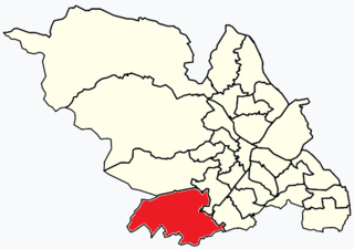
Graves Park ward—which includes the districts of Norton, Norton Lees, Norton Woodseats, and Woodseats—is one of the 28 electoral wards in City of Sheffield, England. It is located in the southern part of the city and covers an area of 5.8 km2. The population of this ward in 2011 was 16,705 people in 7,464 households. It is one of the five wards that form the Sheffield Heeley parliamentary constituency in the House of Commons. The districts of this ward were in the historic county of Derbyshire, but they have now been absorbed into the metropolitan borough of Sheffield, thus placing them in the ceremonial county of South Yorkshire.

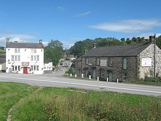
Blackwell is a village in Derbyshire, England. The population of the civil parish at the 2011 census was 4,389. It is one of the four villages that make up the civil parish of Blackwell within the District of Bolsover - the other villages being Hilcote, Newton and Westhouses. The Parish Council meets monthly. A brief history of the Parish of Blackwell was published in 1994.

Beeley is a village and civil parish in northern Derbyshire, England. Located near Bakewell in the Derbyshire Dales, it is situated on the B6012 road, between Rowsley and Edensor. The civil parish population at the 2011 Census was 195.

Brackenfield is a village and civil parish in the North East Derbyshire district of Derbyshire, England. The population of the civil parish as of the 2011 census was 214.

Bradbourne is a village and civil parish in the Derbyshire Dales district of Derbyshire, England. The village is just outside the Peak District National Park, and is 5 miles north of Ashbourne.

Derbyshire Dales is a constituency that has been represented in the House of Commons of the UK Parliament since 2024 by John Whitby of the Labour Party. The constituency was created for the 2010 general election.
Flagg is a small Peak District village and civil parish, set in the Derbyshire Dales, halfway between the small market town of Bakewell and the spa town of Buxton, in the area known as the White Peak. The population of the civil parish as taken at the 2011 Census was 192.
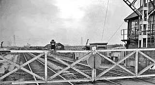
Beighton railway station is a former railway station near the village of Beighton on the border between Derbyshire and South Yorkshire, England.

Alfreton Hall is a country house in Alfreton, Derbyshire. It was at the heart of local social and industrial history in the county. The history of the estate goes back to Norman times, but by the 17th century it was owned by the Morewood family, who were linked to local industry, mainly in coal mining.

Chatsworth is a civil parish in Derbyshire, England, within the area of the Derbyshire Dales and the Peak District National Park.

Stanton in Peak is a village in the Derbyshire Dales district of Derbyshire, It is about seven miles north-west of Matlock, on the north side of Stanton Moor, from Birchover. The name of the civil parish is Stanton with a population taken at the 2011 census of 365. There is a 19th-century parish church, and many stone houses, with mullion windows. There is also a stately home, Stanton Park, a combination of the English Classical style, and later Palladian alterations, which is a private house.
Upperthorpe and Killamarsh was a railway station that served the villages of Killamarsh and Upperthorpe in Derbyshire, England. It was one of three stations serving Killamarsh. The station was on the Sheffield District Railway which ran between Sheffield Victoria and Shirebrook North on the Lancashire, Derbyshire and East Coast Railways network of lines in the region.
Grangemill is a village in the English county of Derbyshire. The hamlet is made up of a cluster of houses, a farm and a pub called the Hollybush. There is a former cheese factory in the village, and the workings of this are still on display. The population as taken at the 2011 Census is included in the civil parish of Aldwark, Derbyshire, The majority of the settlement is within the Ivonbrook Grange parish, however Grangemill lies at the crossroads of the A5012 and B5056 roads which is within Brassington parish. It is on the south-eastern boundary of the Peak District National Park. The Limestone Way long-distance bridleway passes through Grangemill. The Peak District Boundary Walk also runs through the village.

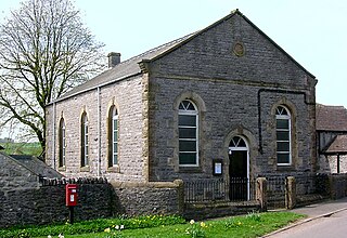
Milltown Methodist Church is a now-closed, listed Methodist chapel in the village of Milltown, Derbyshire.
