
The River Severn, at 220 miles (354 km) long, is the longest river in Great Britain. It is also the river with the most voluminous flow of water by far in all of England and Wales, with an average flow rate of 107 m3/s (3,800 cu ft/s) at Apperley, Gloucestershire. It rises in the Cambrian Mountains in mid Wales, at an altitude of 2,001 feet (610 m), on the Plynlimon massif, which lies close to the Ceredigion/Powys border near Llanidloes. The river then flows through Shropshire, Worcestershire and Gloucestershire. The county towns of Shrewsbury, Worcester and Gloucester lie on its course.

The Avon Gorge is a 1.5-mile (2.5-kilometre) long gorge on the River Avon in Bristol, England. The gorge runs south to north through a limestone ridge 1.5 miles (2.4 km) west of Bristol city centre, and about 3 miles (5 km) from the mouth of the river at Avonmouth. The gorge forms the boundary between the unitary authorities of North Somerset and Bristol, with the boundary running along the south bank. As Bristol was an important port, the gorge formed a defensive gateway to the city.

Bristol Harbour is the harbour in the city of Bristol, England. The harbour covers an area of 70 acres. It is the former natural tidal river Avon through the city but was made into its current form in 1809 when the tide was prevented from going out permanently. A tidal by-pass was dug for 2 miles through the fields of Bedminster for the river, known as the "River Avon New Cut", "New Cut", or simply "The Cut". It is often called the Floating Harbour as the water level remains constant and it is not affected by the state of the tide on the river in the Avon Gorge, The New Cut or the natural river southeast of Temple Meads to its source.
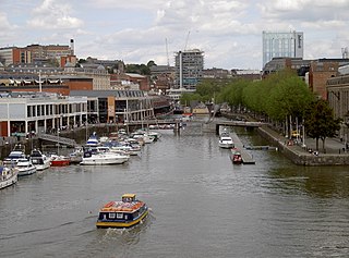
Bristol Ferry Boats is a brand of water bus services operating around Bristol Harbour in the centre of the English city of Bristol, using a fleet of distinctive yellow-and-blue painted ferry boats. The services were formerly owned by the Bristol Ferry Boat Company, but are now the responsibility of Bristol Community Ferry Boats, a community interest company that acquired the fleet of the previous company.

Spike Island is an inner city and harbour area of the English port city of Bristol, adjoining the city centre. It comprises the strip of land between the Floating Harbour to the north and the tidal New Cut of the River Avon to the south, from the dock entrance to the west to Bathurst Basin in the east. The island forms part of Cabot ward. The area between the Docks and New cut to the east of Bathurst Basin is in the neighbourhoods of Redcliffe and St Philip's Marsh.

The Clifton Rocks Railway was an underground funicular in Bristol, England, linking Clifton at the top to Hotwells and Bristol Harbour at the bottom of the Avon Gorge in a tunnel cut through the limestone cliffs.
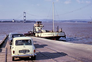
Aust Ferry or Beachley Ferry was a ferry service that operated across the River Severn between Aust and Beachley, both in Gloucestershire, England. Before the Severn Bridge opened in 1966, it provided service for road traffic crossing between the West Country and South Wales. The nearest fixed crossing was a 60-mile (97 km) round trip to Gloucester.

Barrow Haven is a hamlet and small port in North Lincolnshire, England. It was the site of a former ferry crossing that spanned from the Humber Estuary to Hull, serving as a place for ships and boats crossing the Humber to moor away from the tidal flow. A port continues to exist nearby and the area's rail access is based at the Barrow Haven railway station, a stop on the Barton Line.

The Portishead Railway is a branch line railway running from Portishead in North Somerset to the main line immediately west of Bristol, England. It was constructed by the Bristol & Portishead Pier and Railway Company, but it was always operated by its main line neighbour, and was more usually thought of as the Portishead branch or the Portishead railway.

Bower Ashton is a village in south west Bristol on the western boundary with North Somerset, lying within the Southville ward, approximately two miles from the city centre. Ashton Court estate, a 850-acre (3.4 km2) recreational area owned by Bristol City Council lies just to the north, the Long Ashton by-pass to the south and the River Avon to the east.
Hotwells is a neighbourhood in the English port city of Bristol. It is located to the south of and below the high ground of Clifton, and directly to the north of the Floating Harbour. The southern entrance to the Avon Gorge, which connects the docks to the sea, lies at the western end of Hotwells. The eastern end of the area is at the roundabout where Jacobs Well Road meets Hotwell Road. Hotwells is split between the city wards of Clifton, and Hotwells and Harbourside.
The Bristol Port Railway and Pier was a railway in Bristol, England.

New Passage is a hamlet in the civil parish of Pilning and Severn Beach, in the South Gloucestershire, district, in Gloucestershire, England, on the banks of the Severn estuary near the village of Pilning. It takes its name from the ferry service which operated between there and South Wales until 1886.
The majority of public transport users in the Bristol Urban Area are transported by bus, although rail has experienced growth and does play an important part, particularly in peak hours.

The Underfall Yard is a historic boatyard on Spike Island serving Bristol Harbour in England.

Clifton Bridge railway station is a former railway station in the Bower Ashton district of Bristol, England, near the River Avon. It was opened in 1867 by the Bristol and Portishead Pier and Railway Company as a single platform stop 3.4 miles (5.5 km) along the line from Bristol to Portishead. It was later taken over by the Great Western Railway and had a second platform added.

Hotwells railway station, was a railway station situated in the suburb of Hotwells in Bristol, England. It was the original southern terminus of the Bristol Port Railway and Pier which ran to a station and pier at Avonmouth. The station opened in 1865, originally named Clifton station, and was situated in the Avon Gorge almost underneath the Clifton Suspension Bridge, near the Clifton Rocks Railway, the Hotwells terminus of Bristol Tramways, the Rownham ferry and landing stages used by passenger steamers.
The New Cut is an artificial waterway which was constructed between 1804 and 1809 to divert the tidal river Avon through south and east Bristol, England. This was part of the process of constructing Bristol's Floating Harbour, under the supervision of engineer William Jessop. The cut runs from Totterdown Basin at the eastern end of St Phillip's Marsh, near Temple Meads, to the Underfall sluices at Rownham in Hotwells and rejoining the original course of the tidal Avon.

Tower Belle is a passenger boat based in Bristol Harbour in England. The vessel is operated by the Bristol Packet Boat Trips company on pleasure and educational trips in the City Docks, on the River Avon to the Chequers Inn at Hanham Lock and Beese's Tea Gardens at Conham. Tower Belle was built in 1920 in Newcastle upon Tyne by Armstrong Whitworth, originally known as Wincomblee. In the 1950s and 1960s she worked in London, finally coming to Bristol in 1976.
The Bristol International Exhibition was held on Ashton Meadows in the Bower Ashton area of Bristol, England in 1914. The exhibition which had been planned since 1912 was a commercial venture and not fully supported by the civic dignitaries of the city which caused difficulties raising the funds needed. Most of the construction of the venues was from wooden frames covered by plasterboard and occurred in just 2 months prior to opening. It opened on 28 May 1914 was closed on 6 June. Further funding was raised and the exhibition reopened, but continued to struggle with lower than expected attendance and, following several court hearings, finally closed on 15 August just after the outbreak of World War I.
