Roxburghshire or the County of Roxburgh is a historic county and registration county in the Southern Uplands of Scotland. It borders Dumfriesshire to the west, Selkirkshire and Midlothian to the northwest, and Berwickshire to the north. To the southwest it borders Cumberland and to the southeast Northumberland, both in England.
Roxburgh is a civil parish and formerly a royal burgh, in the historic county of Roxburghshire in the Scottish Borders, Scotland. It was an important trading burgh in High Medieval to early modern Scotland. In the Middle Ages it had at least as much importance as Edinburgh, Stirling, Perth, or Berwick-upon-Tweed, for a time acting as de facto capital.
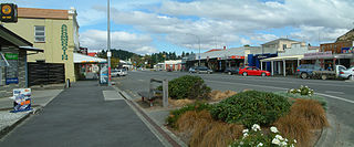
Roxburgh is a small New Zealand town of about 600 people in Central Otago. It is in Teviot Valley on the banks of the Clutha River, 40 kilometres (25 mi) south of Alexandra in the South Island. State Highway 8, which links Central Otago with Dunedin city, passes through the town. Roxburgh is well known for its Summer fruit and "Jimmy's Pies."
The River Teviot, or Teviot Water, is a river of the Scottish Borders area of Scotland, and is the largest tributary of the River Tweed by catchment area. The Teviot is an important river for wildlife, especially the Atlantic salmon, but in recent years has witnessed at least four extreme flooding events.
Nisbet is a small hamlet on the B6400, in Roxburghshire, along the River Teviot, in the Scottish Borders area of Scotland. It is located 5.5 kilometres (3.4 mi) north of Jedburgh and 5 kilometres (3.1 mi) south of Roxburgh.
The Jed Water is a river and a tributary of the River Teviot in the Borders region of Scotland.
Cessford Burn is a small stream which eventually runs to meet the Kale Water and then joins the River Teviot, finally entering the River Tweed at Kelso, Scotland.
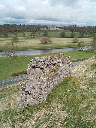
Roxburgh Castle is a ruined royal castle that overlooks the junction of the rivers Tweed and Teviot, in the Borders region of Scotland. The town and castle developed into the royal burgh of Roxburgh, which the Scots destroyed along with the castle after capturing it in 1460. Today the ruins stand in the grounds of Floors Castle, the seat of the Duke of Roxburghe, across the river from Kelso.
Minto is a village and parish in the Scottish Borders area of Scotland in Roxburghshire county. It is located 6 miles north-east of Hawick, north of the River Teviot.
Leader Water is a small tributary of the River Tweed in Lauderdale in the Scottish Borders. It flows southwards from the Lammermuir Hills through the towns of Lauder and Earlston, joining the River Tweed at Leaderfoot.
The Ale Water is a tributary of the River Teviot, in the Scottish Borders area of Scotland. It rises at Henwoodie Hill and flows through Alemoor Loch. It meets the Teviot south of the village of Ancrum, and it runs through Ashkirk and Lilliesleaf. At Ancrum the depth of the water is between 0.26 metres (0.85 ft) and 2.24 metres (7.3 ft), although was as deep at 2.88 metres (9.4 ft) on one occasion in 2002.
Bedrule is a hamlet and civil parish in the historic county of Roxburghshire in the Scottish Borders area of Scotland. The hamlet lies on the east side of the Rule Water, which gave the village its name, about 4 miles west of Jedburgh. It lies south of the A698 between Hawick and Jedburgh. Other local place-names based on the river include Hallrule, Abbotrule, Ruletownhead and Spittal-on-Rule. Larger settlements include Bonchester Bridge and Denholm, as well as Hawick and Jedburgh.
The Kale Water is a 20 miles (32 km) long tributary of the River Teviot in the Scottish Borders area of Scotland. Its feeder burns in the Cheviot Hills are the Long Burn, Hawkwillow Burn and the Grindstone Burn, east of Leithope Forest near the Anglo-Scottish Border.
Kalemouth is a place in the Scottish Borders area of Scotland, where the Kale Water joins the River Teviot, near to Eckford, Cessford, Crailing, Kelso, and Roxburgh.
Eckford is a small village located between the larger towns of Kelso and Jedburgh in the Scottish Borders. The village is in close proximity to both the River Teviot and its tributary the Kale Water, and the A698 and the B6401 which run approximately parallel to the respective rivers.
The Borthwick Water(Border Scots: Borthwick Witter) is a river in the Scottish Borders area of Scotland, and a tributary of the River Teviot.
Crailing is a village on the A698, in Teviotdale, 4m east of Jedburgh in the Scottish Borders area of Scotland, in the historic county of Roxburghshire.
Hassendean is a hamlet in the Scottish Borders south of Edinburgh, Scotland. The stream is the Hassendean Burn which flows down to the River Teviot 5 miles away. The village's name has been written as Hazeldean and Halstaneden.
Wallace's Tower is a ruined 16th-century L-plan tower house, about 3 miles (4.8 km) south west Kelso, Scottish Borders, Scotland, in Roxburgh, west of the River Teviot.
This page is based on this Wikipedia article Text is available under the CC BY-SA 4.0 license; additional terms may apply. Images, videos and audio are available under their respective licenses.