
The Broads is a network of mostly navigable rivers and lakes in the English counties of Norfolk and Suffolk. Although the terms "Norfolk Broads" and "Suffolk Broads" are correctly used to identify specific areas within the two counties respectively, the whole area is frequently referred to as the Norfolk Broads.

Wroxham is a village and civil parish in the English county of Norfolk. The civil parish of Wroxham has an area of 6.21 square kilometres, and in 2001, had a population of 1,532 in 666 households. A reduced population of 1,502 in 653 households was noted in the 2011 Census. The village is situated within the Norfolk Broads on the south side of a loop in the middle reaches of the River Bure. It lies in an elevated position above the Bure, between Belaugh Broad to the west, and Wroxham Broad to the east and south east. Wroxham is some eight miles north-east of Norwich, to which it is linked by the A1151 road. The village and broad lie in an area of fairly intensive agriculture, with areas of wet woodland adjoining the broad and river. For the purposes of local government, the parish falls within the district of Broadland although the river, broad and their immediate environs fall within the executive area of the Broads Authority. On the northern side of the Bure is the village of Hoveton, often confused with Wroxham.

Horning is an ancient village and parish in the English county of Norfolk. It covers an area of 11 km2 and had a population of 1,033 in the 2001 census. Horning parish lies on the northern bank of the River Bure south of the River Thurne and is located in The Broads National Park. For the purposes of local government, it falls within the district of North Norfolk, although areas alongside the rivers and broads fall into the executive area of the Broads Authority.

Wroxham Broad is an area of open water alongside the River Bure near the village of Wroxham in Norfolk, England within The Broads National Park. The Norfolk Broads were formed by the flooding of ancient peat workings. Wroxham Broad has an area of 34.4 hectares and a mean depth of 1.3 metres. It lies to the west of the Bure, with two navigable openings between river and broad. The village and broad lie in an area of fairly intensive agriculture, with areas of wet woodland adjoining the broad and river.

North Norfolk is a constituency represented in the House of Commons of the UK Parliament since 2019 by Duncan Baker, a Conservative.
Hoveton is a village and civil parish in the English county of Norfolk. It is located within the Norfolk Broads, and immediately across the River Bure from the village of Wroxham. Whilst Hoveton is north of the river, Wroxham is south; but many people refer to the whole settlement as "Wroxham".

The River Bure is a river in the county of Norfolk, England, most of it in the Broads. The Bure rises near Melton Constable, 11 miles (18 km) upstream of Aylsham, which was the original head of navigation. Nowadays, the head of navigation is 10 miles (16 km) downstream at Coltishall Bridge. After Aylsham Lock and Burgh Bridge, the Bure passes through Buxton Lammas, Coltishall, Belaugh, Wroxham, Horning, past St. Benet's Abbey, through Oby, Acle, Stokesby, along the northern border of the Halvergate Marshes, through Runham and Great Yarmouth where it meets Breydon Water and flows into the sea at Gorleston.

Aylsham is a historic market town and civil parish on the River Bure in north Norfolk, England, nearly 9 mi (14 km) north of Norwich. The river rises near Melton Constable, 11 miles (18 km) upstream from Aylsham and continues to Great Yarmouth and the North Sea, although it was only made navigable after 1779, allowing grain, coal and timber to be brought up river.

Sprowston is a town and civil parish in the Broadland district of Norfolk, England. It is bounded by Heartsease to the east, Mousehold Heath and the suburb of New Sprowston to the south, Old Catton to the west, and by the open farmland of Beeston St Andrew to the north. It is close to Norwich. The 2011 census recorded a population of 14,691 making Sprowston the most populous civil parish in Broadland district.

The Bittern Line is a railway branch line in Norfolk, England, that links Norwich to Sheringham. It passes through the Broads on its route to an Area of Outstanding Natural Beauty on the north Norfolk coast. It is named after the bittern, a rare bird found in the reedy wetlands of Norfolk.
Worstead railway station is on the Bittern Line in Norfolk, England, serving the villages of Worstead and Sloley. It is 13 miles 12 chains (21.2 km) down the line from Norwich and is situated between Hoveton & Wroxham to the south and North Walsham to the north. Train services are operated by Greater Anglia.

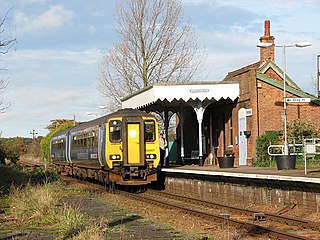
Hoveton & Wroxham railway station is on the Bittern Line in Norfolk, England, serving the village of Hoveton and the adjacent village of Wroxham. It is 8 miles 61 chains (14.1 km) down the line from Norwich and is situated between Salhouse and Worstead.

Salhouse railway station is on the Bittern Line in Norfolk, England, serving the village of Salhouse. It is the next station along the line from Norwich, 5 miles 74 chains (9.5 km) from that terminus; the following station is Hoveton & Wroxham. Train services are operated by Greater Anglia.
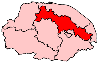
Broadland is a Norfolk constituency, which has been represented in the House of Commons of the UK Parliament since the 2019 general election by Jerome Mayhew, a Conservative.
Wroxham Football Club is a football club based in Wroxham, Norfolk, England. They are currently members of the Isthmian League North Division and play at Trafford Park.

Hainford is a village and civil parish in the English county of Norfolk. It covers an area of 6.94 km2 (2.68 sq mi) and had a population of 951 in 365 households at the 2001 census, increasing to a population of 989 in 391 households at the 2011 Census. For the purposes of local government, it falls within the district of Broadland.

The East Norfolk Railway was a pre-grouping railway company operating a standard gauge 25 mile, mostly single track, railway running between Norwich Thorpe railway station and Cromer in the English county of Norfolk. It opened in 1874, reaching Cromer three years later, and remains mostly operational. The company also operated a branch between Wroxham and County School, which closed to passengers in 1952, and had proposed a branch to Blakeney in 1878, which was never constructed.

Palling Volunteer Rescue Service was originally an independent, voluntary-staffed and charitably-funded inshore rescue service located in the village of Sea Palling in North Norfolk, England. First established by private funds in 1840, it was taken over by the Royal National Lifeboat Institution (RNLI) in 1858 and operated until 1931, when it was closed in a rationalisation of regional lifeboat stations. Revived in 1972 by local people through monies raised from private, business and charitable donations, today the renamed charitable Sea Palling Independent Lifeboat, runs a single 6.3 Ocean Pro RIB, an Arancia ILB and a shoreline rescue Argocat, all covering the area between Eccles-on-Sea and Winterton-on-Sea.

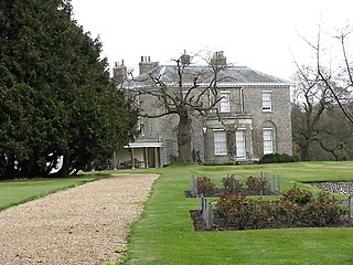
Hoveton Hall in the parish of Hoveton in Norfolk is a Regency-style country house made of gault brick with a slate roof. It was built between 1809 and 1812, on or near the site of the previous ancient manor house of the same name, by Mrs Christabell Burroughes (1764-1843), daughter and heiress of Henry Negus (1734-1807) of Hoveton Hall, an attorney, and wife of James Burkin Burroughes (1760-1803) of Burlingham Hall, Norfolk. The architect was Humphry Repton. It is a well-preserved historic house of significance on the English Heritage Register. The Negus family had been seated at Hoveton Hall for several generations. The surrounding estate today consists of 120 acres of gardens and parkland and 450 acres of arable land as well as picturesque woodland. The gardens are open to the public during part of the year and there are facilities available for accommodation and special events including weddings.

Network Norwich is the brand name given to First Norfolk & Suffolk bus services in and around the city of Norwich. First launched in September 2012, the network now consists of nine colour-coded lines extending across Norwich city centre, outer suburbs, and surrounding towns and villages across Norfolk and into Suffolk.

