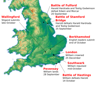
Neath Abbey was a Cistercian monastery, located near the present-day town of Neath in South Wales, UK. It was once the largest abbey in Wales. Substantial ruins can still be seen, and are in the care of Cadw. Tudor historian John Leland called Neath Abbey "the fairest abbey of all Wales."

Ramsey Abbey was a Benedictine abbey in Ramsey, Huntingdonshire, England. It was founded in AD 969 and dissolved in 1537.

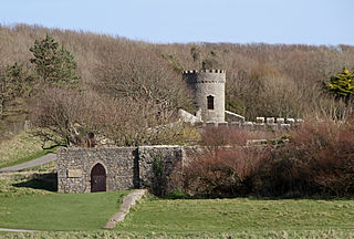
Liverpool Castle was a castle in Liverpool, England, that stood from the early 13th century to the early 18th century.

Woodspring Priory is a former Augustinian priory. It is near the scenic limestone promontory of Sand Point and Middle Hope, owned by the National Trust, beside the Severn Estuary about 3 miles (5 km) north-east of Weston-super-Mare, within the English unitary authority of North Somerset. Many of the buildings are Grade I listed, and the whole site is scheduled as an ancient monument.

Kilclief Castle is a tower-house castle beside Strangford Lough and 2.5 miles (4 km) south of the village of Strangford, County Down, Northern Ireland. Kilclief is a hamlet of historical value on the Strangford to Ardglass road. This kind of tower-house is sometimes called the gatehouse type, because of its similarity to a castle gatehouse. It is among the oldest tower houses in Lecale. Kilclief Castle tower house is a State Care Historic Monument in the townland of Kilclief, in Down District Council area, at grid ref: J5972 4575.

Walton is a settlement in the East Suffolk district, in the county of Suffolk, England, lying between the rivers Orwell and Deben. It is part of Felixstowe parish.

Moreton Corbet is a village in the civil parish of Moreton Corbet and Lee Brockhurst in Shropshire, England. The village's toponym refers to the Corbet baronets, the local landowners.
Buckton Castle was a medieval enclosure castle near Carrbrook in Stalybridge, Greater Manchester, England. It was surrounded by a 2.8-metre-wide (9 ft) stone curtain wall and a ditch 10 metres (33 ft) wide by 6 metres (20 ft) deep. Buckton is one of the earliest stone castles in North West England and only survives as buried remains overgrown with heather and peat. It was most likely built and demolished in the 12th century. The earliest surviving record of the site dates from 1360, by which time it was lying derelict. The few finds retrieved during archaeological investigations indicate that Buckton Castle may not have been completed.
Abinger Castle is a mound that was topped by a small, fortified wooden castle during part of the 12th century at Abinger Common, between Guildford and Dorking in Surrey, England. The castle reached a fairly prominent vantage point with a half-panorama overlooking the two roads that diverge by the neighbouring church, having descended from the Leith Hill escarpments at the border of West Sussex.
Benington Castle is a ruined castle in the village of Benington, near Stevenage in Hertfordshire, England at grid reference TL296236. It has been protected since 1936 as a scheduled ancient monument.

Rougemont Gardens is an ornamental open space adjacent to Rougemont Castle in the city of Exeter, Devon, England. It is Grade II listed in the National Register of Historic Parks and Gardens. Originally part of the defences of the castle, it was converted into a garden in the late 18th century, and purchased by the city council in 1912.

Filleigh is a small village, civil parish and former manor in North Devon, on the southern edge of Exmoor, 3 1/2 miles west of South Molton. The village centre's street was, until the 1980s opening of the North Devon Link Road, the main highway between the North Devon administrative centre of Barnstaple and South Molton, leading westwards to Taunton. Much of the village's land is contained within grade I listed park and garden, Castle Hill, which straddles both sides of the Link Road providing a glimpse of some of it.

Rufus Castle, also known as Bow and Arrow Castle, is a partially ruined castle overlooking Church Ope Cove on Portland, England. Its name derives from King William II, known as William Rufus, for whom the original castle was built.

MacDuff's Castle is a ruined castle near East Wemyss, in Fife, Scotland. The site is associated with the MacDuff Earls of Fife, the most powerful family in Fife in the middle ages, although nothing survives from this period. The present ruins are the remains of the home of the Wemyss family, who lived here from the 14th century, and their successors in the 16th century.
Mackworth Castle was a 14th- or 15th-century structure located in Derbyshire, at the upper end of Mackworth village near Derby. The home for several centuries of the Mackworth family, it was at some point reduced to the ruins of a gatehouse suggestive of a grand castle. A survey from 1911 suggested that though the gatehouse resembled a castle, the rest of the structure may have been more modest. The remains are part of a designated Scheduled Ancient Monument.

Pennard Castle is a ruined castle, near the modern village of Pennard on the Gower Peninsula, in south Wales. The castle was built in the early 12th century as a timber ringwork following the Norman invasion of Wales. The walls were rebuilt in stone by the Braose family at the turn of the 13th and 14th centuries, including a stone gatehouse. Soon afterwards, however, encroaching sand dunes caused the site to be abandoned and it fell into ruin. Restoration work was carried out during the course of the 20th century and the remains of the castle are now protected under UK law as a Grade II* listed building.

Warkworth Castle is a ruined medieval building in the village of the same name in the English county of Northumberland. The village and castle occupy a loop of the River Coquet, less than a mile from England's north-east coast. When the castle was founded is uncertain: traditionally its construction has been ascribed to Prince Henry of Scotland, Earl of Northumbria, in the mid-12th century, but it may have been built by King Henry II of England when he took control of England's northern counties. Warkworth Castle was first documented in a charter of 1157–1164 when Henry II granted it to Roger fitz Richard. The timber castle was considered "feeble", and was left undefended when the Scots invaded in 1173.
Dunraven Castle was a mansion on the South Wales coast near Southerndown. The existing manor house was rebuilt as a castellated hunting lodge in the early 19th century and was extensively remodelled later in the century. The surviving parts of the house and its lands are Grade II listed buildings.

Whorlton Castle is a ruined medieval castle situated near the abandoned village of Whorlton in North Yorkshire, England. It was built in the early 12th century as a Norman motte-and-bailey associated with the nearby settlement. The castle is an unusual example of a motte-and-bailey that remained in use throughout the Middle Ages and into the early modern period. Built to overlook an important road on the western edge of the North York Moors, the castle fell into ruin as early as the mid-14th century. The site nonetheless continued to be inhabited until at least the early 17th century. Little now remains of the castle itself, other than the remnants of some cellars or undercrofts. The ruined shell of a 14th-century gatehouse still survives, albeit in fairly poor condition. It is a listed building and is privately owned but can be visited by the public.
Uffington is a civil parish in Shropshire, England. In the parish are 13 listed buildings that are recorded in the National Heritage List for England. Of these, one is listed at Grade I, the highest of the three grades, and the others are at Grade II, the lowest grade. The parish contains the village of Uffington, and is otherwise mainly rural. In the parish are the remains of Haughmond Abbey, which is listed at Grade I, and is also a Scheduled Monument. Also in the parish was Sundorne Castle, a country house that has been demolished. A number of structures associated with the house have survived, and are listed. The other listed buildings include houses, cottages, farmhouses and farm buildings, the earliest of which are timber framed, a pump in an enclosure, and a church.