Ruhuhu River

Last updated
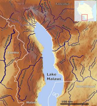
The Ruhuhu (right center) Lake Malawie Tanzania OSM.png
The Ruhuhu (right center)

The Ruhuhu River is a river in Ruvuma Region, Tanzania.

Contents

Geography

The source of the Ruhuhu is on the eastern slope of the Kipengere Range (Livingstone Mountains) in Tanzania, where it first flows southeast and then turns west to Lake Nyasa (Lake Malawi). It is over 300 km (190 mi) long, of which the last 100 km (62 mi) is a single deep gorge. The river's mouth is just south of Manda. [1] [2]

Catchment area

At over 14,000 km2 (5,400 sq mi) (between 14,070–14,200 km2 (5,430–5,480 sq mi) depending on the data source), the Ruhuhu River Basin is the largest of the Malawiese River Basins and the largest in Tanzania. As the longest river flowing into Lake Malawi, by convention it is the headwaters of the Shire, which drains the lake. The Ruhuhu carries water all year round.

Hydrometry

The discharge of the Ruhuhu was measured in m3/s for 43 years (1971-2015) at the Kikonge gauge, about 20 km (12 mi) upstream of the mouth. However the values in other sources are higher by a factor of about four.

The Tanzanian government decided in 2016 to install a hydroelectric power station with an expected capacity of 300 MW (400,000 hp) (Kikonge Hydroelectric Power Station) at this location.

Related Research Articles

<span class="mw-page-title-main">Geography of Mozambique</span> Geographical features of Mozambique

The geography of Mozambique consists mostly of coastal lowlands with uplands in its center and high plateaus in the northwest. There are also mountains in the western portion. The country is located on the east coast of southern Africa, directly west of the island of Madagascar. Mozambique has a tropical climate with two seasons, a wet season from October to March and a dry season from April to September.

<span class="mw-page-title-main">Nile</span> Major river in northeastern Africa

The Nile is a major north-flowing river in northeastern Africa. It flows into the Mediterranean Sea. The Nile is the longest river in Africa and has historically been considered the longest river in the world, though this has been contested by research suggesting that the Amazon River is slightly longer. Of the world's major rivers, the Nile is one of the smallest, as measured by annual flow in cubic metres of water. About 6,650 km (4,130 mi) long, its drainage basin covers eleven countries: the Democratic Republic of the Congo, Tanzania, Burundi, Rwanda, Uganda, Kenya, Ethiopia, Eritrea, South Sudan, Sudan, and Egypt. In particular, the Nile is the primary water source of Egypt, Sudan and South Sudan. Additionally, the Nile is an important economic river, supporting agriculture and fishing.

<span class="mw-page-title-main">Geography of Tanzania</span>

Tanzania comprises many lakes, national parks, and Africa's highest point, Mount Kilimanjaro. Northeast Tanzania is mountainous, while the central area is part of a large plateau covered in grasslands. The country also contains the southern portion of Lake Victoria on its northern border with Uganda and Kenya.

<span class="mw-page-title-main">Zambezi</span> Major river in southern Africa

The Zambezi is the fourth-longest river in Africa, the longest east-flowing river in Africa and the largest flowing into the Indian Ocean from Africa. Its drainage basin covers 1,390,000 km2 (540,000 sq mi), slightly less than half of the Nile's. The 2,574 km (1,599 mi) river rises in Zambia and flows through eastern Angola, along the north-eastern border of Namibia and the northern border of Botswana, then along the border between Zambia and Zimbabwe to Mozambique, where it crosses the country to empty into the Indian Ocean.

<span class="mw-page-title-main">Neman</span> River in Northeast Europe

The Neman,Niemen, Nyoman, Nemunas or Memel is a river in Europe that rises in central Belarus and flows through Lithuania then forms the northern border of Kaliningrad Oblast, Russia's western exclave, which specifically follows its southern channel. It drains into the Curonian Lagoon, narrowly connected to the Baltic Sea. The 937 km (582 mi) long Neman is a major Eastern European river. It flows generally west to Grodno within 12 kilometres (7.5 mi) of the Polish border, north to Kaunas, then westward again to the sea.

<span class="mw-page-title-main">Mackenzie River</span> Largest river system in Canada

The Mackenzie River is a river in the Canadian boreal forest. It forms, along with the Slave, Peace, and Finlay, the longest river system in Canada, and includes the second largest drainage basin of any North American river after the Mississippi.

<span class="mw-page-title-main">Selenga</span> River in Mongolia and Russia

The Selenga or Selenge is a major river in Mongolia and Buryatia, Russia. Originating from its headwater tributaries, the Ider and the Delger mörön, it flows for 992–1,024 kilometres (616–636 mi) before draining into Lake Baikal. The Selenga therefore makes up the most distant headwaters of the Yenisey-Angara river system.

<span class="mw-page-title-main">Una (Sava)</span> River between Bosnia and Herzegovina and Croatia

The Una is a border river between Bosnia and Herzegovina and Croatia and a right tributary of the Sava river. It is part of the Black Sea drainage basin, and its watershed has a size of 10,200 km2 (3,900 sq mi), of which 8,080 km2 (3,120 sq mi) belongs to Bosnia and Herzegovina, and 2,120 km2 (820 sq mi) to Croatia. The total length of the river is 212 km (132 mi). The source of the river is located near the village of Donja Suvaja in Croatia, and its mouth is located near the village of Jasenovac, on the border with Bosnia. The largest right tributaries are the Krka, Unac, Krušnica and Sana rivers, and the largest left tributary is the Klokot river. Its longest headwater is the Unac river. The largest and most important city located on the river is Bihać. Other, important cities and towns are Bosanska Krupa, Bosanski Novi and Bosanska Kostajnica. The river is characterized by a multitude of waterfalls, rapids, karst springs and relatively untouched nature. A large part of the upper river is part of the Una National Park.

<span class="mw-page-title-main">Ruvuma River</span> River along the Tanzania–Mozambique border

Ruvuma River, formerly also known as the Rovuma River, is a river in the African Great Lakes region. During the greater part of its course, it forms the border between Tanzania and Mozambique. The river is 998 km (620 mi) long, with a drainage basin of ~155,000 km2 (60,000 sq mi) in size. Its mean annual discharge is 475 m3/s (16,800 cu ft/s) to 2,286 m3/s (80,700 cu ft/s) at its mouth.

The Kipengere Range, also known as the Livingstone Mountains, lies entirely in Njombe Region in southwest Tanzania at the northern end of Lake Nyasa. Near Lake Nyasa they are known as the Kinga Mountains. It is a plateau-like ridge of mountains running southeastwards from the basin of the Great Ruaha River in the north to that of the Ruhuhu River in the south, and forms part of the eastern escarpment of the East African Rift. The range is mostly clad in montane grasslands, renowned for their botanical diversity and displays of flowers, with montane evergreen forests mostly in stream valleys.

The Trebišnjica is a river in Bosnia and Herzegovina, and the right tributary of the Neretva. Before it was utilized for hydro exploitation via various hydrotechnical interventions and systems with different purposes, Trebišnjica used to be a sinking river, rising and sinking through its course before resurfacing at various places from the Neretva river below the Čapljina to the Adriatic coast, and along the coast from the Neretva Delta to Sutorina.

<span class="mw-page-title-main">Nipigon River</span> River in Ontario, Canada

The Nipigon River is located in Thunder Bay District in Northwestern Ontario, Canada. The river is about 48 km (30 mi) long and 50 to 200 m wide, and flows from Lake Nipigon to Nipigon Bay on Lake Superior at the community of Red Rock, dropping from an elevation of 260 to 183 m. It is the largest tributary of Lake Superior.

<span class="mw-page-title-main">Dwangwa River</span> River in Malawi

The Dwangwa River is a river in Malawi, which flows into Lake Malawi. Its source is in the Kasungu National Park, in Malawi's central plateau. It flows north-easterly from this plateau through an ancient valley. The river's mouth flows out of a more recently cut gorge, into the lake. It also flows through the Bana Swamp. Its length is approximately 100 miles (160 km).

<span class="mw-page-title-main">Lake Qaraoun</span> Multipurpose reservoir in Beqaa Valley

Lake Qaraoun is an artificial lake or reservoir located in the southern region of the Beqaa Valley, Lebanon. It was created near Qaraoun village in 1959 by building a 61 m-high (200 ft) concrete-faced rockfill dam in the middle reaches of the Litani River. The reservoir has been used for hydropower generation, domestic water supply, and for irrigation of 27,500 ha.

<span class="mw-page-title-main">Batiscan River</span> River in Quebec, Canada

Batiscan River has its source in the region of Lac Édouard, in the Laurentians Mountains, the Batiscan River flows over a length of 177 km. It receives water from numerous tributaries, including, in its upper reach, the Rivière aux Éclairs and the Jeannotte river. In its downstream part, it waters Saint-Narcisse and Sainte-Geneviève-de-Batiscan before flowing into the St. Lawrence River at Batiscan.

<span class="mw-page-title-main">Taltson River</span> River in Northwest Territories, Canada

The Taltson River is a roughly 500 km (310 mi) river in the Northwest Territories of Canada that drains into the Great Slave Lake. There are three hydroelectric power control structures on the river, and one power station.

<span class="mw-page-title-main">Churchill Falls Generating Station</span> Hydroelectric power station in north eastern Canada

The Churchill Falls Generating Station is a hydroelectric underground power station in Labrador. At 5,428 MW, it is the sixteenth largest in the world, and the second-largest in Canada, after the Robert-Bourassa generating station in northwestern Quebec.

<span class="mw-page-title-main">Pangani River</span> River in northeastern Tanzania

The Pangani River, is a major river of northeastern Tanzania. It has two main sources: the Ruvu, which rises as Lumi at Kilimanjaro, passes through Lake Jipe, and empties into the Nyumba ya Mungu Reservoir, and the Kikuletwa River, coming from the west and mainly fed by rivers of Mount Meru in Arusha Region, which also enters into the Nyumba ya Mungu Reservoir in Kilimanjaro Region. Just after leaving the reservoir the stream becomes the main Pangani, which empties into the Indian Ocean in Tanga Region at the Tangan port town of Pangani.

<span class="mw-page-title-main">Shannon River Basin</span> River in Ireland

The Shannon River Basin consists of the area containing Ireland's longest river, the River Shannon, and all of its tributaries and lakes. The official Ordnance Survey Ireland length of the Shannon from its Shannon Pot source is 224 miles (360 km) made up of 63.5 miles (102.2 km) tidal water flow and 160.5 miles (258.3 km) freshwater flow.

Kikonge Hydroelectric Power Station project is a proposed 300 MW (400,000 hp) hydroelectric dam in Ruvuma Region, Tanzania.

References

  1. "Ruhuhu River | river, Tanzania | Britannica". www.britannica.com. Retrieved 2022-02-14.
  2. "Ruhuhu River, Tanzania". www.geonames.org. Retrieved 2022-02-14.

10°31′S34°34′E / 10.517°S 34.567°E / -10.517; 34.567