Related Research Articles
Arnesenodden is a headland on Svenskøya in Kong Karls Land, Svalbard. It is the most northern point of Svenskøya, at the foot of the mountain Mohnhøgda. The headland is named after Arctic explorer Magnus Arnesen.
Kyrkjevika is a bay at the southwestern coast of Svenskøya in Kong Karls Land, Svalbard. Kyrkjevika is partly sheltered by Antarcticøya and other islands.
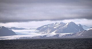
Eidembreen is a glacier in Oscar II Land at Spitsbergen, Svalbard. It has a length of about eighteen kilometers, and debouches into Eidembukta in Forlandsundet, between St. Jonsfjorden and Isfjorden. The glacier is named after Norwegian politician and naval officer Ole Thorenius Eidem. Eidembreen belongs to the mountain and glacier complex of Trollheimen. Further north are Austgötabreen and Huldrebreen, and to the south are Stallobreen and Heksebreen.
Trollheimen is a mountainous area in Oscar II Land at Spitsbergen, Svalbard, around the glacier of Eidembreen. Among the mountains of Trollheimen are Tussekallen, Runebomma, Heksefjellet, Huldrefjellet, Huldrehatten, Tomtegubben, and parts of Gunnar Knudsenfjella. North of Eidembreen is the glacier of Huldrebreen, and to the south are Heksebreen and Stallobreen.
Huldrefjellet is a mountain in Oscar II Land at Spitsbergen, Svalbard. The mountain has a height of 725 m.a.s.l. and is located north of Eidembreen, between Huldrebreen and Austgötabreen. Huldrefjellet is part of the Trollheimen range.
Gunnar Knudsenfjella is a mountain group in Oscar II Land at Spitsbergen, Svalbard. The mountains are located south of St. Jonsfjorden, and are surrounded by the glaciers of Charlesbreen, Løvliebreen and Eidembreen.
Løvliebreen is a glacier in Oscar II Land at Spitsbergen, Svalbard. It has a length of about five kilometers, and is located between the mountain ranges of Gunnar Knudsenfjella and Holmesletfjella. The glacier debouches northwards towards St. Jonsfjorden. It is named after Norwegian businessperson Andreas Løvlie along with the nearby mountain of Løvliefjellet.
Heksefjellet is a mountain in Oscar II Land at Spitsbergen, Svalbard. It reaches a height of 774 m.a.s.l. and is located between the glaciers of Heksebreen and Stallobreen, south of Eidembreen. The mountain is part of the mountainous district of Trollheimen.
Heksebreen is a glacier in Oscar II Land at Spitsbergen, Svalbard. It has a length of about 3.5 kilometers, and is a tributary glacier to Eidembreen. The glacier is located south in the mountainous district of Trollheimen, and is surrounded by the mountains of Heksefjellet, Runebomma, Trollungen and Stortrollet.
Løvliefjellet is a mountain in Oscar II Land at Spitsbergen, Svalbard. It reaches a height of 710 m a.s.l., and has an extension of about two kilometers. The mountain is located south of St. Jonsfjorden, between the glaciers of Vestgötabreen and Løvliebreen. It, along with the Løvliebreen glacier, is named after Norwegian business person Andreas Løvlie (1860-1915).
Tomtegubben is a mountain in Oscar II Land at Spitsbergen, Svalbard. It has a height of 779 m.a.s.l., and is located between the glaciers of Borebreen and Eidembreen. Tomtegubben is part of the mountainous district of Trollheimen.
Tussekallen is a mountain in Oscar II Land at Spitsbergen, Svalbard. It has a height of 729 m.a.s.l., and is located between the glaciers of Venernbreen and Eidembreen. Tussekallen is part of the mountainous district of Trollheimen.
Venernbreen is a glacier in Oscar II Land at Spitsbergen, Svalbard. It has a length of about fifteen kilometers, and is located between the mountains of Sparrefjellet and Kinnefjellet. The glacier is named after the Swedish lake of Vänern.
Kinnefjellet is a mountain in Oscar II Land at Spitsbergen, Svalbard. It has peaks with heights of 601 and 544 m.a.s.l. and is located at the southern side of Venernbreen. The mountain is named after the hill of Kinnekulle in the Swedish province of Västergötland.
Huldrebreen is a glacier in Oscar II Land at Spitsbergen, Svalbard. It is surrounded by the mountains of Huldrehatten, Huldrefjellet and Bytingen, west in the mountainous district of Trollheimen. Huldrebreen and Austgötabreen are located north of the glacier complex of Eidembreen. The glacier is named after Hulder in Scandinavian folklore.

Huldrehatten is a mountain in Oscar II Land at Spitsbergen, Svalbard. It reaches a height of 787 m.a.s.l., and is located west in the mountainous district of Trollheimen, north of the glacier complex of Eidembreen, and north of Huldrefjellet. The mountain is named after Hulder in Scandinavian folklore.

Stallofjellet is a mountain in Oscar II Land at Spitsbergen, Svalbard. It reaches a height of 735 m.a.s.l. The mountain is located between the glaciers of Venernbreen, Stallobreen and Eidembreen, and has an extension of about three kilometers.

Linnédalen is a valley in Nordenskiöld Land at Spitsbergen, Svalbard. It is named after Swedish botanist Carl Linnaeus. The valley has a length of about ten kilometers, and is located east of the mountain ridge of Linnéfjella. In the lower part of the valley is the lake of Linnévatnet, which is among the largest lakes of Spitsbergen.
Linnéfjella is a mountain ridge in Nordenskiöld Land at Spitsbergen, Svalbard. It is named after Swedish botanist Carl Linnaeus. The ridge contains the mountains of Solryggen, Aagaardtoppen, Griegfjellet and Griegaksla. East of the ridge is the valley of Linnédalen.

Hayesbreen is a glacier in Sabine Land at Spitsbergen, Svalbard. It is named after American politician and Arctic explorer Isaac Israel Hayes. The glacier has a length of about eighteen kilometers, and debouches into the bay of Mohnbukta. Surrounding mountains are Aagaardfjellet to the north, Jebensfjellet to the south, and Panofskyfjellet where Hayesbreen joins the glacier of Königsbergbreen.
References
- ↑ "Runebomma (Svalbard)". Norwegian Polar Institute . Retrieved 24 April 2014.
- ↑ "Trollheimen (Svalbard)". Norwegian Polar Institute . Retrieved 24 April 2014.
78°23′02″N13°28′34″E / 78.384°N 13.476°E
| | This Spitsbergen mountain, mountain range, or peak related article is a stub. You can help Wikipedia by expanding it. |