The Huari Province is one of twenty provinces of the Ancash Region in Peru. Its seat is Huari.

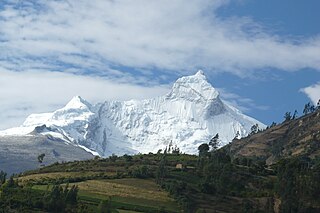
Tullparaju is a mountain in the Cordillera Blanca in the Andes of Peru, about 5,787 metres (18,986 ft) high. It is situated in the Ancash Region, Huaraz Province, Independencia District, and in the Huari Province, Huari District. Tullparaju lies southeast of the mountains Pucaranra and Chinchey and northeast of Andavite. It is situated at the end of the Quilcayhuanca valley, northeast of the lake Tullpacocha.
Challwaqucha may refer to:
Markahirka or Marka Hirka is an archaeological site with cave paintings and stone tombs (chullpa) on a mountain of the same name in Peru. It is located in the Ancash Region, Huari Province, in the districts of Cajay and Masin. It is situated at a height of 3,580 metres (11,745 ft). Markahirka is also a good viewpoint with views into the Puchka valley (Puchca) and to the towns of Huari (Wari) and Huachis (Wachis).

Waraqayuq or Warak'ayuq is a mountain with an archaeological site of the same name in the Cordillera Blanca in the Andes of Peru, about 4,600 metres (15,092 ft) high. It is situated in the Ancash Region, Huari Province, Chavin de Huantar District, east of the mountain Yanamaray.
Carhuascancha or Tumarinaraju is a mountain in the Cordillera Blanca in the Andes of Peru with an elevation of 5,648 metres (18,530 ft) or 5,668 metres (18,596 ft) above sea level. It is situated in the Ancash Region, Huari Province, Huantar District, and in the Huaraz Province, Huaraz District. Carhuascancha lies north-west of Huantsán.
Jacabamba is a 5,566-metre-high (18,261 ft) mountain in the Cordillera Blanca in the Andes of Peru. It is situated in the Ancash Region, Asunción Province, Chacas District, in the Carhuaz Province, Marcará District, and in the Huari Province, Huari District. Jacabamba lies between mount Copap to the north and Chinchey to the south. Lake Rurichinchay lies at its feet.
Pukarahu or Puka Rahu may refer to:
Tuctu is a mountain in the Cordillera Blanca in the Andes of Peru, about 5,000 metres (16,404 ft) high. It is situated in the Ancash Region, Huaraz Province, Olleros District, and in the Huari Province, Chavin de Huantar District. It lies southeast of Arhuay, Uruashraju and Tuctopunta.
Tarush Huachanan is a mountain in the Cordillera Blanca in the Andes of Peru, 5,205 m (17,077 ft) high. It is situated in the Ancash Region, Asunción Province, Chacas District, and in the Huari Province, Huari District. Tarush Huachanan lies in the Huascarán National Park, northeast of Perlilla.
Pucaraju is a mountain in the Cordillera Blanca in the Andes of Peru, about 4,800 m (15,748 ft) high. It is situated in the Ancash Region, Huari Province, Huari District. Pucaraju lies on a ridge east of Jacabamba.
Arteza is a mountain in the Cordillera Blanca in the Andes of Peru, about 5,000 metres (16,404 ft) high. It is situated in the Ancash Region, Huari Province, Huantar District. Arteza lies at the Qarwakancha valley, southeast of Andavite and Cayesh and northeast of Qarwakancha and Maparaju.
Puka Mach'ay is a mountain in the Cordillera Blanca in the Andes of Peru, about 5,000 m (16,404 ft) high. It is located in the Ancash Region, Huari Province, Chavín de Huantar District. Puka Mach'ay lies east of Qishqi. One of the little lakes south of it is named Pukaqucha.
Pucarajo is a mountain in the Andes of Peru, about 5,000 m (16,404 ft) high. It is situated in the Ancash Region, Bolognesi Province, Huallanca District, and in the Huari Province, San Marcos District. Pucarajo lies northwest of the Yanashallash pass.
Yanaccacca is a mountain in the Cordillera Blanca in the Andes of Peru which reaches a height of approximately 4,200 m (13,780 ft). It is located in the Ancash Region, Huari Province, Huari District, southwest of Huari. The Rurichinchay River flows along its southern slope.
Quinuajirca or Kinwa Hirka is a mountain in the eastern extensions of the Cordillera Blanca in the Andes of Peru which reaches a height of approximately 4,400 m (14,400 ft). It is located in the Ancash Region, Huari Province, Huari District. Quinuajirca lies at the Rurichinchay valley, northeast of the peak of Chinchey.
Jatunjirca is a mountain in the eastern part of the Cordillera Blanca in the Andes of Peru which reaches a height of approximately 3,800 m (12,500 ft). It is located in the Ancash Region, Huari Province, Huari District, southwest of Huari and west of the village of Yacya.
Kunkush is a mountain in the Andes of Peru which reaches a height of approximately 4,400 m (14,400 ft). It is located in the Ancash Region, Huari Province, Paucas District.
Waman Wayi is a mountain in the Andes of Peru which reaches a height of approximately 4,400 m (14,436 ft). It is located in the Ancash Region, Huari Province, San Marcos District.