Related Research Articles

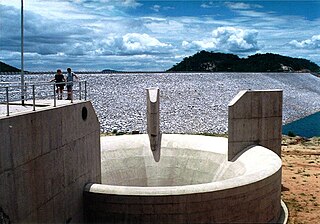
The Kariba Dam is a double curvature concrete arch dam in the Kariba Gorge of the Zambezi river basin between Zambia and Zimbabwe. The dam stands 128 metres (420 ft) tall and 579 metres (1,900 ft) long. The dam forms Lake Kariba, which extends for 280 kilometres (170 mi) and holds 185 cubic kilometres (150,000,000 acre⋅ft) of water.

Victoria Falls is a waterfall on the Zambezi River in southern Africa, which provides habitat for several unique species of plants and animals. It is located on the border between Zambia and Zimbabwe and is one of the world's largest waterfalls, with a width of 1,708 m (5,604 ft).
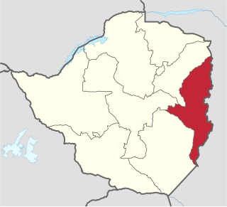
Manicaland is a province in eastern Zimbabwe. After Harare Province, it is the country's second-most populous province, with a population of 2.037 million, as of the 2022 census. After Harare and Bulawayo provinces, it is Zimbabwe's third-most densely populated province. Manicaland was one of five original provinces established in Southern Rhodesia in the early colonial period. The province endowed with country's major tourist attractions, the likes of Mutarazi Falls, Nyanga National Park and Zimbabwe's top three highest peaks. The province is divided into ten administrative subdivisions of seven rural districts and three towns/councils, including the provincial capital, Mutare. The name Manicaland is derived from one of the province's largest ethnic groups, the Manyika, who originate from the area north of the Manicaland province and as well as western Mozambique, who speak a distinct language called ChiManyika in Shona.
Kariba is a resort town in Mashonaland West province, Zimbabwe, located close to the Kariba Dam at the north-eastern end of Lake Kariba, near the Zambian border. According to the 2022 Population Census, the town had a population of 27,600.
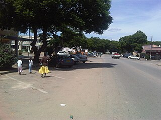
Rusape is a town in Zimbabwe.

Nyanga National Park lies in the north of Zimbabwe's Eastern Highlands. One of the first national parks to be declared in the country, it contains the highest land in Zimbabwe, with green hills and perennial rivers. Most of its terrain consists of rolling downland, sometimes lightly wooded, lying at altitudes between 1,800–2,593 metres. Mount Nyangani, the highest point in Zimbabwe, lies in the centre of the park and Mutarazi Falls, Zimbabwe's highest waterfall, is in the south of the park. Nyanga National park incorporates the former Mutarazi Falls National Park on its southern boundary.
The Jews of Rusape, Zimbabwe are a group of people who practice a religion similar to Judaism. Their observance of Judaism is generally in accordance with that of mainstream Judaism practiced in other countries with the exception of a few key aspects. The Rusape Jews, believe that although Jesus was not the Messiah, he was a prophet. They believe that he did not rise to heaven as is taught in Christianity, but was rather buried in Israel as a regular man. The community's origins are attributed to an individual known as William S. Crowdy, who came to the community in the late 19th or early 20th century.

The Shashe River is a major left-bank tributary of the Limpopo River in Zimbabwe. It rises northwest of Francistown, Botswana and flows into the Limpopo River where Botswana, Zimbabwe and South Africa meet. The confluence is at the site of the Greater Mapungubwe Transfrontier Conservation Area.
Manyuchi Dam forms a reservoir on the Mwenezi River in southern Zimbabwe. It is located in the Mwenezi District. The building of the dam was financed by the Mwenezi Development Corporation. The dam was built to irrigate oil palm estates.

The Mwenezi River, originally known as the Nuanetsi River, is a major tributary of the Limpopo River. The Mwenezi River starts up in south central Zimbabwe and flows south-east along what is known as the Mwenezi River Valley that bisects the district into two sectors. The river is found in both Zimbabwe and Mozambique. In Zimbabwe it has been known as the Nuanetsi or Nuanetzi River in the past, a name it retains in Mozambique.

The Insiza River is the principal tributary of the Mzingwane River in Zimbabwe.
The Osborne Dam site on the Odzi River, Zimbabwe, was identified in the 1950s by the planning engineers of the Ministry of Water. Cored drilling investigations on the two possible alignments were completed in the 1960s. After the completion of Mazvikadei dam [1985–'88] under Italian aid finance, further funding became available for the project and when the 10 000 hectares of potential irrigable land was identified downstream the project was approved in 1989 by the multi-ministry irrigation committee of the Zimbabwe Government.
Zhovhe Dam is a reservoir on the Mzingwane River, Zimbabwe with a capacity of 133 million cubic metres. It supplies water for commercial irrigation and the town of Beitbridge.

The Bubye River, also known as Bubi River, is a tributary of the Limpopo River in Beitbridge District and Gwanda District, Zimbabwe. It rises about 40 kilometres (25 mi) to the northeast of West Nicholson in Matabeleland South, from where it flows southeast before joining the Limpopo about 25 kilometres (16 mi) west of the border with Mozambique. Its course forms part of the border between Mberengwa and Mwenezi districts.

Columbina Rural Service Center is a populated place in Zhombe. It is 95 km northwest of Kwekwe and 67 km southwest of Kadoma.
Ngondoma Irrigation Scheme is located in Zhombe, Kwekwe District in Zimbabwe's Agro-Ecological Region Three. The average annual rainfall for the location is 550 mm. The scheme area is 44.4 4 hectares. Of the 179 farmers in the scheme, 134 are women. It comprises members from various villages, including villagers from Chief Njelele side, Gokwe District on the other side of Ngondoma River.
Rusape River is a long inland water river stretching from the almost evergreen Nyanga regions to Save river in Zimbabwe. It is known to be usually flooded during summer and has numerous myth stories associated with it. Rusape river is the major feeding river to Rusape dam in the outskirts of Rusape town as well as to irrigate sugarcane and wheat estates in the Lowveld. Stream bank cultivation and illegal sand abstraction is contributing to siltation of Rusape river which flows into the Rusape dam.

Ngondoma Dam is a dam on the Ngondoma River located 500 meters west of the Empress Mine Township in the Midlands Province of Zimbabwe. The dam is 67 kilometers northwest of the Kwekwe and 54 km southwest of Kadoma.
Exchange Irrigation Scheme is a 165 hectare irrigated arable land in Zhombe Communal Land but in Silobela Constituency in Kwekwe District of the Midlands Province of Zimbabwe. It is 37 km southwest of Zhombe Joel, 83 km northwest of Kwekwe and 25 km north of Crossroads DSC.
References
- ↑ "ENVIRONMENTAL FLOW REQUIREMENTS OF THE RUSAPE RIVER, TRANSBOUNDARY SAVE BASIN, ZIMBABWE" F. Love, E. Madamombe, B. Marshall and E. Kaseke, Mbi F.doc - Waternet. Accessed 5 June 2015
- ↑ Bulawayo 24 News, 30 May 2014. Accessed 5 June 2015