
Kansas City, Missouri is the largest city in the U.S. state of Missouri by population and area. The city lies within Jackson, Clay, Platte counties, and a small portion in Cass County. It is the central city of the Kansas City metropolitan area, which straddles the Missouri–Kansas state line and has a population of 2,392,035. As of the 2020 census, the city had a population of 508,090, making it the 37th most-populous city in the United States, as well as the sixth-most populous city in the Midwest. Kansas City was founded in the 1830s as a port on the Missouri River at its confluence with the Kansas River from the west. On June 1, 1850, the town of Kansas was incorporated; shortly after came the establishment of the Kansas Territory. Confusion between the two ensued, and the name Kansas City was assigned to distinguish them soon after.

Topeka is the capital city of the U.S. state of Kansas and the county seat of Shawnee County. It is along the Kansas River in the central part of Shawnee County, in northeast Kansas, in the Central United States. As of the 2020 census, the population of the city was 126,587. The Topeka metropolitan statistical area, which includes Shawnee, Jackson, Jefferson, Osage, and Wabaunsee Counties, had a population of 233,870 in the 2010 census.

East St. Louis is a city in St. Clair County, Illinois, United States. It is directly across the Mississippi River from downtown St. Louis, Missouri, and the Gateway Arch National Park. East St. Louis is in the Metro East region of Southern Illinois. Once a bustling industrial center, like many cities in the Rust Belt, East St. Louis was severely affected by the loss of jobs due to the flight of the population to the suburbs during the riots of the late 1960s. In 1950, East St. Louis was the fourth-largest city in Illinois when its population peaked at 82,366. As of the 2020 census, the city had a population of 18,469, less than one-quarter of the 1950 census and a decline of almost one third since 2010. It has one of the highest homicide rates in the United States.

Kansas City (KCK) is the third-most populous city in the U.S. state of Kansas and the county seat of Wyandotte County. It is an inner suburb of the older and more populous Kansas City, Missouri, after which it is named. As of the 2020 census, the population of the city was 156,607, making it one of four principal cities in the Kansas City metropolitan area. It is situated at Kaw Point, the junction of the Missouri and Kansas rivers. It is part of a consolidated city-county government known as the "Unified Government". It is the location of the University of Kansas Medical Center and Kansas City Kansas Community College.

On March 18, 1925, one of the deadliest tornado outbreaks in recorded history generated at least 12 significant tornadoes and spanned a large portion of the midwestern and southern United States. In all, at least 751 men, women and children were killed and more than 2,298 were injured, making the outbreak the deadliest tornado outbreak in U.S. history. The outbreak generated several destructive tornadoes in Missouri, Illinois, and Indiana on the same day, as well as significant tornadoes in Alabama and Kansas. In addition to confirmed tornadoes, there were undoubtedly others with lesser impacts, the occurrences of which have been lost to history.

Algiers is a historic neighborhood of New Orleans and is the only Orleans Parish community located on the West Bank of the Mississippi River. Algiers is known as the 15th Ward, one of the 17 Wards of New Orleans. It was once home to many jazz musicians and is also the second oldest neighborhood in the city.

East Oakland is a geographical region of Oakland, California, United States, that stretches between Lake Merritt in the northwest and San Leandro in the southeast. As the southeastern portion of the city, East Oakland takes up the largest portion of the city's land area.

Pigtown is a neighborhood in the southwest area of Baltimore, bordered by Martin Luther King Jr. Boulevard to the east, Monroe Street to the west, Russell Street to the south, and West Pratt Street to the north. The neighborhood acquired its name during the second half of the 19th century, when the area was the site of butcher shops and meat packing plants to process pigs transported from the Midwest on the B&O Railroad; they were herded across Ostend and Cross Streets to be slaughtered and processed.

On June 20, 1957, a violent and deadly F5 tornado commonly known as the Fargo tornado, struck the north side of Fargo, North Dakota as well as the area north of Moorhead, Minnesota. It was part of a family of five devastating tornadoes produced by one supercell over the course of 3.5 hours, although they are listed as one continuous tornado. The tornado family started in North Dakota, traveled 27.4 miles (44.1 km) to the Minnesota border before crossing it and continuing for another 25 miles (40 km) for a total track length of 52.4 miles (84.3 km). Additionally, at its widest point, the damage swath reached 500 yards (460 m) across. A total of 10 people were killed, making it the deadliest tornado in North Dakota history. Meanwhile, 103 others were injured, and damage was estimated at $25.25 million. It was part of a larger outbreak sequence of 23 tornadoes that affected the Midwest and Great Plains.
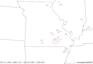
From May 19–22, 1957, a tornado outbreak took place across the US Central Plains. A total of 59 tornadoes were reported from Colorado to the Mississippi Valley. The most destructive tornado of the severe weather event—likely part of a long-lived family—was rated at F5, the highest level, and is often called the Ruskin Heights tornado, after the site of its worst damage, a suburb and housing development in southern Kansas City, Missouri. Additionally, a powerful F4 tornado virtually destroyed Fremont, Missouri, claiming seven lives, and an F3 tornado killed eight others in and near Belgrade, Missouri. A pair of F4s—one in Minnesota, the other in Kansas—also neared F5 intensity. In all, 59 people were killed during the outbreak, including 44 in the Ruskin Heights tornado.

From May 4–6, 2007, a major and damaging tornado outbreak significantly affected portions of the Central United States. The most destructive tornado in the outbreak occurred on the evening of May 4 in western Kansas, where about 95% of the city of Greensburg in Kiowa County was destroyed by an EF5 tornado, the first of the new Enhanced Fujita Scale and such intensity since the 1999 Bridge Creek–Moore tornado. The supercell killed 13 people, including 11 in Greensburg and two from separate tornadoes. At least 60 people were injured in Greensburg alone. It was the strongest tornado of an outbreak which included several other tornadoes reported across Oklahoma, Colorado, Kansas and South Dakota that occurred on the same night.

Tornadoes are more common in the United States than in any other country or state. The United States receives more than 1,200 tornadoes annually—four times the amount seen in Europe. Violent tornadoes—those rated EF4 or EF5 on the Enhanced Fujita Scale—occur more often in the United States than in any other country.
Spring Hill is a city in Johnson and Miami counties in the U.S. state of Kansas, and part of the Kansas City Metropolitan Area. As of the 2020 census, the population of the city was 7,952, and was estimated to be 9,689 in 2023.

The 2011 Joplin tornado was a large and devastating multiple-vortex tornado that struck Joplin, Missouri, United States, on the evening of Sunday, May 22, 2011. Part of a larger late-May tornado outbreak, the EF5 tornado began just west of Joplin and intensified very quickly, reaching a maximum width of nearly one mile (1.6 km) during its path through the southern part of the city. The tornado tracked eastward through Joplin, and then continued across Interstate 44 into rural portions of Jasper and Newton counties, weakening before it dissipated.
Racial segregation in Atlanta has known many phases after the freeing of the slaves in 1865: a period of relative integration of businesses and residences; Jim Crow laws and official residential and de facto business segregation after the Atlanta Race Riot of 1906; blockbusting and black residential expansion starting in the 1950s; and gradual integration from the late 1960s onwards. A 2015 study conducted by Nate Silver of fivethirtyeight.com, found that Atlanta was the second most segregated city in the U.S. and the most segregated in the South.

Jess & Jim's Steakhouse is a steakhouse restaurant located on 135th Street in Martin City, Missouri. Founded in 1938, Jess & Jim's has been ranked numerous times by national publications as one of the best steakhouses in the United States.

National Weather Service - Pleasant Hill/Kansas City, Missouri is a Weather Forecast Office (WFO) of the National Weather Service, which is responsible for forecasts and the dissemination of weather warnings and advisories for 37 counties in northern and western Missouri and seven counties in extreme eastern Kansas, including the Kansas City and St. Joseph metropolitan areas. Though, as the Storm Prediction Center (SPC) in Norman, Oklahoma is responsible for issuing severe thunderstorm and tornado watches, the Pleasant Hill/Kansas City WFO only composes outline and status updates for SPC-issued watches affecting any portion of its designated County Warning Area.

This page documents the tornadoes and tornado outbreaks of 1958, primarily in the United States. Most tornadoes form in the U.S., although some events may take place internationally. Tornado statistics for older years like this often appear significantly lower than modern years due to fewer reports or confirmed tornadoes.

A deadly and destructive outbreak sequence of 23 tornadoes struck parts of the Great Plains and the Great Lakes in late-June 1957. At least seven significant tornadoes (F2+) touched down during the outbreak sequence. The most devastating storm was a large, violent, and catastrophic 500-yard-wide F5 tornado family that struck Fargo, North Dakota on Thursday, June 20, 1957, killing 10 people and becoming the deadliest tornado ever recorded in North Dakota. The outbreak caused 11 fatalities, 105 injuries, and $25.883 million in damage.

In the evening hours of May 20, 1957, a large, long-tracked and deadly tornado moved through portions of eastern Kansas and western Missouri, killing forty-four people and injuring over five hundred. The tornado is the deadliest to strike the Kansas City metropolitan area, and was the deadliest worldwide in 1957. Intensity was rated F5 on the Fujita scale, the first of three worldwide to receive this rating in 1957.
