Ruzunga | |
|---|---|
 Ruzunga Location in Burundi | |
| Coordinates: 3°51′29″S29°38′43″E / 3.85806°S 29.64528°E | |
| Country | |
| Province | Bururi Province |
Ruzunga is a town in the Bururi Province of Burundi.
Ruzunga | |
|---|---|
| Ruzunga Location in Burundi | |
| Coordinates: 3°51′29″S29°38′43″E / 3.85806°S 29.64528°E | |
| Country | |
| Province | Bururi Province |
Ruzunga is a town in the Bururi Province of Burundi.

USS Fuller (DD-297) was a Clemson-class destroyer built for the United States Navy during World War I.

Lozen Saddle is a 437 m high saddle situated between Lozen Nunatak and Zograf Peak in Tangra Mountains, eastern Livingston Island in the South Shetland Islands, Antarctica which provides overland access from the Wörner Gap area to the Shipka Valley. The saddle was first crossed by the Bulgarian Lyubomir Ivanov from Camp Academia on 17 December 2004, and takes its name from the adjacent Lozen Nunatak.
Nesebar Gap is a 1.3 km wide gap in eastern Livingston Island in the South Shetland Islands, Antarctica bounded to the west by Pliska Ridge and to the east by the northern slope of Mount Friesland, Tangra Mountains. It is part of the divide between the glacial catchments of Perunika Glacier to the north and Huntress Glacier to the south. The gap is part of an overland route between Orpheus Gate to the west, and Camp Academia locality and Lozen Saddle to the east.
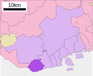
Tarumi is one of nine wards of Kobe, Japan. It has an area of 26.89 km2, and a population of 219,958 (2008).
The James Fork is a 50.3-mile-long (81.0 km) river in the U.S. states of Arkansas and Oklahoma, forming on the north slope of Poteau Mountain in the Ouachita National Forest in Arkansas and flowing north and west into the Poteau River near Panama, Oklahoma. Via the Poteau and Arkansas rivers, the James Fork is part of the Mississippi River watershed.
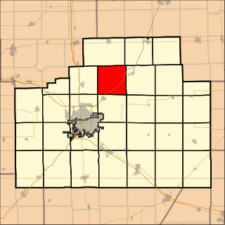
Money Creek Township is located in McLean County, Illinois. As of the 2010 census, its population was 1,085 and it contained 511 housing units.

Djoue is a department of Haut-Ogooué Province in south-eastern Gabon. The capital lies at Onga. It had a population of 2,178 in 2013.

The Grand Loop Road is a historic district which encompasses the primary road system in Yellowstone National Park. Much of the 140-mile (230 km) system was originally planned by Captain Hiram M. Chittenden of the US Army Corps of Engineers in the early days of the park, when it was under military administration. The Grand Loop Road provides access to the major features of the park, including the Upper, Midway and Lower geyser basins, Mammoth Hot Springs, Tower Fall, the Grand Canyon of the Yellowstone and Yellowstone Lake.
Lahıc is a village in the Goygol Rayon of Azerbaijan.
Türkmən is a village in the Qabala Rayon of Azerbaijan.
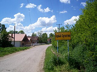
Gornje Suhotno is a village in the municipality of Aleksinac, Serbia. According to the 2002 census, the village has a population of 343 people.

Forte de Santa Catarina das Mós is a fort in the Azores. It is located in Angra do Heroísmo, on the island of Terceira.
Nhlambeni is an inkhundla of Eswatini, located in the Manzini District. Its population as of the 2007 census was 12,466.
Soapstone is an unincorporated community in Pittsylvania County, in the U.S. state of Virginia.

Ozona Air Force Station is a closed United States Air Force General Surveillance Radar station. It is located 5 miles (8.0 km) east of Ozona, Texas. It was closed in 1963.

The Marshyangdi is a mountain river in Nepal. Its length is about 150 kilometres.
Stancil is an extinct town in Pemiscot County, in the U.S. state of Missouri. The GNIS classifies it as a populated place.

The Community of the Sacred Name is a community of nuns in the Anglican Church in Aotearoa New Zealand and Polynesia. CSN Sisters currently live in Christchurch, Ashburton, Nukualofa and Suva. The former Motherhouse of the community including convent, chapel and novitiate stood in the central city of Christchurch, New Zealand.

Prospekt Slavy (Russian: Проспект Славы is a Saint Petersburg Metro station on the Frunzensko–Primorskaya Line of the Saint Petersburg Metro. It was opened on 3 October 2019 as a part of the extension of the line to the south from Mezhdunarodnaya. The extension also included Dunayskaya and Shushary stations. Prospect Slavy is located between Mezhdunarodnaya and Dunayskaya.
The Chandler Reservation is a 1,524-acre (617 ha) protected area owned by the town of Warner, New Hampshire, United States. The 400-acre (160 ha) Harriman Chandler State Forest borders it to the southwest. The reservation covers the northern end of the Mink Hills, with elevations ranging from 500 feet (150 m) above sea level in the north to 1,750 feet (530 m) on the crest of the range.
3°51′29″S29°38′43″E / 3.85806°S 29.64528°E
| | This Burundi location article is a stub. You can help Wikipedia by expanding it. |