Truskolasy is a village in the administrative district of Gmina Wręczyca Wielka, within Kłobuck County, Silesian Voivodeship, in southern Poland. It lies approximately 8 kilometres (5 mi) west of Wręczyca Wielka, 11 km (7 mi) south-west of Kłobuck, and 68 km (42 mi) north of the regional capital Katowice. Between 1975 and 1998 Truskolasy belonged to Częstochowa Voivodeship.

Łobodno is a village in the administrative district of Gmina Kłobuck, within Kłobuck County, Silesian Voivodeship, in southern Poland. It lies approximately 4 kilometres (2 mi) east of Kłobuck and 74 km (46 mi) north of the regional capital Katowice.

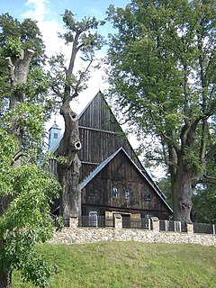
Danków is a village in the administrative district of Gmina Lipie, within Kłobuck County, Silesian Voivodeship, in southern Poland. It lies approximately 2 kilometres (1 mi) south of Lipie, 14 km (9 mi) north-west of Kłobuck, and 85 km (53 mi) north of the regional capital Katowice.
Cyganka is a village in the administrative district of Gmina Panki, within Kłobuck County, Silesian Voivodeship, in southern Poland. It lies approximately 3 kilometres (2 mi) west of Panki, 16 km (10 mi) west of Kłobuck, and 74 km (46 mi) north of the regional capital Katowice.
Bór Zajaciński is a village in the administrative district of Gmina Przystajń, within Kłobuck County, Silesian Voivodeship, in southern Poland. It lies approximately 7 kilometres (4 mi) south-west of Przystajń, 22 km (14 mi) south-west of Kłobuck, and 70 km (43 mi) north of the regional capital Katowice.
Brzeziny is a village in the administrative district of Gmina Przystajń, within Kłobuck County, Silesian Voivodeship, in southern Poland. It lies approximately 4 kilometres (2 mi) south of Przystajń, 20 km (12 mi) south-west of Kłobuck, and 71 km (44 mi) north of the regional capital Katowice.
Dąbrowa is a village in the administrative district of Gmina Przystajń, within Kłobuck County, Silesian Voivodeship, in southern Poland. It lies approximately 6 kilometres (4 mi) south of Przystajń, 20 km (12 mi) south-west of Kłobuck, and 69 km (43 mi) north of the regional capital Katowice.
Ługi-Radły is a village in the administrative district of Gmina Przystajń, within Kłobuck County, Silesian Voivodeship, in southern Poland. It lies approximately 7 kilometres (4 mi) south-west of Przystajń, 22 km (14 mi) south-west of Kłobuck, and 70 km (43 mi) north of the regional capital Katowice.
Wilcza Góra is a village in the administrative district of Gmina Przystajń, within Kłobuck County, Silesian Voivodeship, in southern Poland. It lies approximately 4 kilometres (2 mi) south of Przystajń, 18 km (11 mi) south-west of Kłobuck, and 70 km (43 mi) north of the regional capital Katowice.
Brzezinki is a village in the administrative district of Gmina Wręczyca Wielka, within Kłobuck County, Silesian Voivodeship, in southern Poland. It lies approximately 10 kilometres (6 mi) west of Wręczyca Wielka, 14 km (9 mi) south-west of Kłobuck, and 67 km (42 mi) north of the regional capital Katowice.
Długi Kąt is a village in the administrative district of Gmina Wręczyca Wielka, within Kłobuck County, Silesian Voivodeship, in southern Poland. It lies approximately 6 kilometres (4 mi) west of Wręczyca Wielka, 11 km (7 mi) south-west of Kłobuck, and 66 km (41 mi) north of the regional capital Katowice.
Golce is a village in the administrative district of Gmina Wręczyca Wielka, within Kłobuck County, Silesian Voivodeship, in southern Poland. It lies approximately 5 kilometres (3 mi) west of Wręczyca Wielka, 8 km (5 mi) south-west of Kłobuck, and 70 km (43 mi) north of the regional capital Katowice.
Hutka is a village in the administrative district of Gmina Wręczyca Wielka, within Kłobuck County, Silesian Voivodeship, in southern Poland. It lies approximately 8 kilometres (5 mi) north-west of Wręczyca Wielka, 8 km (5 mi) south-west of Kłobuck, and 72 km (45 mi) north of the regional capital Katowice.
Kalej is a village in the administrative district of Gmina Wręczyca Wielka, within Kłobuck County, Silesian Voivodeship, in southern Poland. It lies approximately 4 kilometres (2 mi) south-east of Wręczyca Wielka, 10 km (6 mi) south of Kłobuck, and 66 km (41 mi) north of the regional capital Katowice.
Klepaczka is a village in the administrative district of Gmina Wręczyca Wielka, within Kłobuck County, Silesian Voivodeship, in southern Poland. It lies approximately 8 kilometres (5 mi) west of Wręczyca Wielka, 11 km (7 mi) south-west of Kłobuck, and 68 km (42 mi) north of the regional capital Katowice.
Kuleje is a village in the administrative district of Gmina Wręczyca Wielka, within Kłobuck County, Silesian Voivodeship, in southern Poland. It lies approximately 12 kilometres (7 mi) west of Wręczyca Wielka, 15 km (9 mi) south-west of Kłobuck, and 67 km (42 mi) north of the regional capital Katowice.
Piła Druga is a village in the administrative district of Gmina Wręczyca Wielka, within Kłobuck County, Silesian Voivodeship, in southern Poland. It lies approximately 10 kilometres (6 mi) west of Wręczyca Wielka, 14 km (9 mi) south-west of Kłobuck, and 67 km (42 mi) north of the regional capital Katowice.
Piła Pierwsza is a village in the administrative district of Gmina Wręczyca Wielka, within Kłobuck County, Silesian Voivodeship, in southern Poland. It lies approximately 10 kilometres (6 mi) west of Wręczyca Wielka, 12 km (7 mi) south-west of Kłobuck, and 69 km (43 mi) north of the regional capital Katowice.
Wydra is a village in the administrative district of Gmina Wręczyca Wielka, within Kłobuck County, Silesian Voivodeship, in southern Poland. It lies approximately 6 kilometres (4 mi) south-east of Wręczyca Wielka, 12 km (7 mi) south of Kłobuck, and 63 km (39 mi) north of the regional capital Katowice.
Zamłynie is a village in the administrative district of Gmina Wręczyca Wielka, within Kłobuck County, Silesian Voivodeship, in southern Poland. It lies approximately 10 kilometres (6 mi) west of Wręczyca Wielka, 12 km (7 mi) south-west of Kłobuck, and 69 km (43 mi) north of the regional capital Katowice.


