
Capertee pronounced is a village 46 km north of Lithgow, New South Wales, Australia. It is on an elevated site above the Capertee Valley. In 2016, the township had a population of 145 people. The Castlereagh Highway links Capertee with Lithgow to the south and Mudgee to the north. The township is surrounded by National Parks and grazing land. Principal employment is in coal mining, farming and tourism-related services. The Capertee Valley forms a part of the catchment area of the Hawkesbury River, but the village lies very close to the Great Divide watershed, with the Turon River catchment nearby to its west.
Scone railway station is a heritage-listed railway station located on the Main Northern line in Scone, in the Upper Hunter Shire local government area of New South Wales, Australia. The station serves the town of Scone and opened on 17 April 1871. The property was added to the New South Wales State Heritage Register on 2 April 1999.

Ilford is a village in New South Wales, Australia, beside the Crudine River within the Mid-Western Regional Council. It is located on the Castlereagh Highway, about 220 kilometres north-west of Sydney. At the 2016 census Ilford and the surrounding rural district had a population of 187, living in 65 private dwellings. The district also included 43 unoccupied private dwellings. Ilford was named after the English township of Ilford, from where early residents of the locality originated.
Bathurst railway station is a heritage-listed railway station located on Havannah Street, Bathurst, New South Wales, Australia. It is situated on the Main Western line and is the only railway station serving the city. The station was added to the New South Wales State Heritage Register on 2 April 1999.

Rylstone is a small town in New South Wales, Australia, in the Central Tablelands region within the Mid-Western Regional Council local government area. It is located on the Bylong Valley Way road route. At the 2021 census, Rylstone had a population of 904.
Kandos is a small town in the Central Tablelands of New South Wales, Australia, within the Mid-Western Regional Council. The area is the traditional home of the Dabee tribe of the Wiradjuri people. The town sits beneath Cumber Melon Mountain, in a district formerly known as Coomber. Kandos shares its locality, employment and infrastructure with the neighbouring town Rylstone, 6 kilometres away. At the 2021 census, Kandos had a population of 1263.

The City of Lithgow is a local government area in the Central West region of New South Wales, Australia. The area is located adjacent to the Great Western Highway and the Main Western railway line.

The Gwabegar railway line is a railway line in the Central West and North West Slopes of New South Wales, Australia, which passes through the towns of Mudgee, Gulgong, Dunedoo, Coonabarabran and terminates at Gwabegar.

Culcairn railway station is a heritage-listed railway station located on the Main Southern line in New South Wales, Australia. It serves the town of Culcairn. It was added to the New South Wales State Heritage Register on 2 April 1999.

The Murwillumbah railway station is a heritage-listed former terminus railway station located on the Murwillumbah line in South Murwillumbah, in the Tweed Shire local government area of New South Wales, Australia. The former railway station is also known as the Murwillumbah Railway Station and yard group. The station opened on 24 December 1894 and closed on 16 May 2004 when the line from Casino was closed.

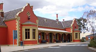
Dubbo railway station is a heritage-listed railway station and bus interchange located on the Main Western line in Dubbo, New South Wales, Australia. The station serves the city of Dubbo and was opened on 1 February 1881. The station is also known as Dubbo Railway Station and yard group. The property was added to the New South Wales State Heritage Register on 2 April 1999. The station and associated yards were designed by the office of the Engineer-in-Chief of the NSW Government Railways, under the direction of John Whitton.

Rydal railway station is a heritage-listed railway station located on the Main Western line in Rydal, City of Lithgow, New South Wales, Australia. It is also known as Rydal Railway Station group. The property was added to the New South Wales State Heritage Register on 2 April 1999.

Tarana railway station is a heritage-listed railway station located on the Main Western line in Tarana, in the Central West region of New South Wales, Australia. It is also known as the Tarana Railway Station and yard group. The property was added to the New South Wales State Heritage Register on 2 April 1999.
Wallerawang railway station is a heritage-listed disused railway station located on the Main Western line in Wallerawang, City of Lithgow, New South Wales, Australia. It is also known as Wallerawang railway station and yard group. The property was added to the New South Wales State Heritage Register on 2 April 1999.

Coonamble railway station is a heritage-listed former railway station at Coonamble in the Orana region of New South Wales, Australia. It served as the terminus for passenger services on the Coonamble railway line and was added to the New South Wales State Heritage Register on 2 April 1999.

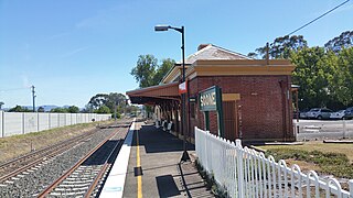
Gulgong railway station is a heritage-listed former railway station on the Gwabegar railway line at Gulgong, Mid-Western Regional Council, New South Wales, Australia. The property was added to the New South Wales State Heritage Register on 2 April 1999.

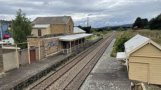
Lue railway station is a heritage-listed former railway station on the Gwabegar railway line at Lue, Mid-Western Regional Council, New South Wales, Australia. It was added to the New South Wales State Heritage Register on 2 April 1999.

The Cooerwull railway footbridge is a heritage-listed pedestrian bridge located at Top Points Station on the Zig Zag Railway at Lithgow, New South Wales, Australia. It was built in 1941. It was added to the New South Wales State Heritage Register on 2 April 1999.

The Rydal rail underbridges are a series of heritage-listed railway underbridges and viaducts that carry the Main Western line over Solitary Creek at Rydal, in the City of Lithgow local government area of New South Wales, Australia. The property is owned by Transport Asset Holding Entity, an agency of the Government of New South Wales. It was added to the New South Wales State Heritage Register on 2 April 1999.
Clandulla is a village in New South Wales, Australia, within the Mid-Western Regional Council, about 225 kilometres north-west of Sydney. At the 2016 census Clandulla and the surrounding rural district had a population of 197, living in 61 private dwellings. The township and district also included 22 unoccupied private dwellings. Clandulla is bounded to the west and north by the Clandulla State Forest.


