Gmina Biecz is an urban-rural gmina in Gorlice County, Lesser Poland Voivodeship, in southern Poland. Its seat is the town of Biecz, which lies approximately 12 kilometres (7 mi) north-east of Gorlice and 102 km (63 mi) east of the regional capital Kraków.
Gmina Moszczenica is a rural gmina in Gorlice County, Lesser Poland Voivodeship, in southern Poland. Its seat is the village of Moszczenica, which lies approximately 9 kilometres (6 mi) north-west of Gorlice and 93 km (58 mi) south-east of the regional capital Kraków. The gmina also includes the village of Staszkówka.
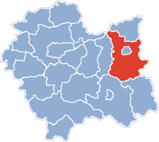
Gmina Ciężkowice is an urban-rural gmina in Tarnów County, Lesser Poland Voivodeship, in southern Poland. Its seat is the town of Ciężkowice, which lies approximately 26 kilometres (16 mi) south of Tarnów and 80 km (50 mi) east of the regional capital Kraków.
Gmina Gromnik is a rural gmina in Tarnów County, Lesser Poland Voivodeship, in southern Poland. Its seat is the village of Gromnik, which lies approximately 23 kilometres (14 mi) south of Tarnów and 77 km (48 mi) east of the regional capital Kraków.
Gmina Rzepiennik Strzyżewski is a rural gmina in Tarnów County, Lesser Poland Voivodeship, in southern Poland. Its seat is the village of Rzepiennik Strzyżewski, which lies approximately 27 kilometres (17 mi) south of Tarnów and 85 km (53 mi) east of the regional capital Kraków.
Gmina Tuchów is an urban-rural gmina in Tarnów County, Lesser Poland Voivodeship, in southern Poland. Its seat is the town of Tuchów, which lies approximately 16 kilometres (10 mi) south of Tarnów and 82 km (51 mi) east of the regional capital Kraków.
Gmina Szerzyny is a rural gmina in Tarnów County, Lesser Poland Voivodeship, in southern Poland. Its seat is the village of Szerzyny, which lies approximately 31 kilometres (19 mi) south-east of Tarnów and 99 km (62 mi) east of the regional capital Kraków.

Ciężkowice-Rożnów Landscape Park is a protected area in southern Poland, established in 1995, covering an area of 176.34 square kilometres (68.09 sq mi).
Pasmo Brzanki Landscape Park is a protected area in southern Poland, established in 1995.

Rzepiennik Marciszewski is a village in the administrative district of Gmina Gromnik, within Tarnów County, Lesser Poland Voivodeship, in southern Poland. It lies approximately 23 kilometres (14 mi) south of Tarnów and 82 km (51 mi) east of the regional capital Kraków.
Kołkówka is a village in the administrative district of Gmina Rzepiennik Strzyżewski, within Tarnów County, Lesser Poland Voivodeship, in southern Poland. It lies approximately 5 kilometres (3 mi) north-east of Rzepiennik Strzyżewski, 26 km (16 mi) south of Tarnów, and 88 km (55 mi) east of the regional capital Kraków.
Olszyny is a village in the administrative district of Gmina Rzepiennik Strzyżewski, within Tarnów County, Lesser Poland Voivodeship, in southern Poland. It lies approximately 7 kilometres (4 mi) east of Rzepiennik Strzyżewski, 27 km (17 mi) south of Tarnów, and 91 km (57 mi) east of the regional capital Kraków.

Rzepiennik Biskupi is a village in the administrative district of Gmina Rzepiennik Strzyżewski, within Tarnów County, Lesser Poland Voivodeship, in southern Poland. It lies approximately 3 kilometres (2 mi) east of Rzepiennik Strzyżewski, 27 km (17 mi) south of Tarnów, and 88 km (55 mi) east of the regional capital Kraków.
Rzepiennik Suchy is a village in the administrative district of Gmina Rzepiennik Strzyżewski, within Tarnów County, Lesser Poland Voivodeship, in southern Poland. It lies approximately 6 kilometres (4 mi) east of Rzepiennik Strzyżewski, 29 km (18 mi) south of Tarnów, and 90 km (56 mi) east of the regional capital Kraków.
Turza is a village in the administrative district of Gmina Rzepiennik Strzyżewski, within Tarnów County, Lesser Poland Voivodeship, in southern Poland. It lies approximately 5 kilometres (3 mi) south of Rzepiennik Strzyżewski, 31 km (19 mi) south of Tarnów, and 88 km (55 mi) east of the regional capital Kraków.
Wola Rzędzińska is a village in the administrative district of Gmina Tarnów, within Tarnów County, Lesser Poland Voivodeship, in southern Poland. It lies approximately 7 kilometres (4 mi) east of Tarnów and 82 km (51 mi) east of the regional capital Kraków.
Dąbrówka Tuchowska is a village in the administrative district of Gmina Tuchów, within Tarnów County, Lesser Poland Voivodeship, in southern Poland. It lies approximately 4 kilometres (2 mi) south of Tuchów, 19 km (12 mi) south of Tarnów, and 83 km (52 mi) east of the regional capital Kraków.

Olszowa is a village in the administrative district of Gmina Zakliczyn, within Tarnów County, Lesser Poland Voivodeship, in southern Poland. It lies approximately 6 kilometres (4 mi) south of Zakliczyn, 30 km (19 mi) south-west of Tarnów, and 69 km (43 mi) south-east of the regional capital Kraków.

Paleśnica is a village in the administrative district of Gmina Zakliczyn, within Tarnów County, Lesser Poland Voivodeship, in southern Poland. It lies approximately 6 kilometres (4 mi) south of Zakliczyn, 30 km (19 mi) south-west of Tarnów, and 69 km (43 mi) south-east of the regional capital Kraków.
Kosorowice is a village in the administrative district of Gmina Tarnów Opolski, within Opole County, Opole Voivodeship, in south-western Poland. It lies approximately 3 kilometres (2 mi) west of Tarnów Opolski and 13 km (8 mi) south-east of the regional capital Opole.