The Rammelsberg is a mountain, 635 metres (2,083 ft) high, on the northern edge of the Harz range, south of the historic town of Goslar in the North German state of Lower Saxony. The mountain is the location of an important silver, copper, and lead mine, the only mine which had been working continuously for over 1,000 years when it finally closed in 1988. Since 1992, the visitor mine of Rammelsberg has become a UNESCO World heritage site.
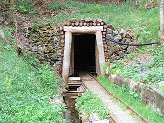
An adit is an entrance to an underground mine which is horizontal or nearly horizontal, by which the mine can be entered, drained of water, ventilated, and minerals extracted at the lowest convenient level. Adits are also used to explore for mineral veins.

The Upper Harz Mining Museum is a museum of technological and cultural history in Clausthal-Zellerfeld in the Harz mountains of central Germany. It is one of the oldest technological museums in Germany and concentrates on the history and presentation of mining in the Upper Harz up to the 19th century.

The Upper Harz Water Regale is a system of dams, reservoirs, ditches and other structures, much of which was built from the 16th to 19th centuries to divert and store the water that drove the water wheels of the mines in the Upper Harz region of Germany. The term regale, here, refers to the granting of royal privileges or rights in this case to permit the use of water for mining operations in the Harz mountains of Germany.

Mining in the Upper Harz region of central Germany was a major industry for several centuries, especially for the production of silver, lead, copper, and, latterly, zinc as well. Great wealth was accumulated from the mining of silver from the 16th to the 19th centuries, as well as from important technical inventions. The centre of the mining industry was the group of seven Upper Harz mining towns of Clausthal, Zellerfeld, Sankt Andreasberg, Wildemann, Grund, Lautenthal und Altenau.

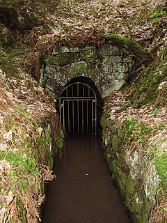
The Samson Pit or Samson Mine is an historic silver mine in Sankt Andreasberg in the Upper Harz region of central Germany.
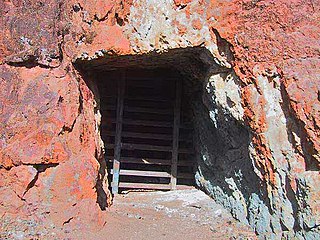
The Roter Bär Pit in Sankt Andreasberg in the Upper Harz is an iron ore mine that was worked from about 1800 until the 1860s. Today it is operated as a show mine under the name of Roter Bär Pit Educational Mine by the Sankt Andreasberg Society for History and Archaeology. The name Roter Bär means "Red Bear".

A Kunstteich is an historic German term for a man-made lake or pond associated with the mining industry and its technology. These ponds were created by the construction of barriers, typically dams and embankments, and were used to supply hydropower and water to the mines. Water stored in the reservoir was used for a variety of purposes. It was used to turn water wheels that in turn drove the various mechanical devices used in mining in earlier centuries, such as man engines. It was also used to produce power and drain the mines, or in the processing of ore. In principle, all Kunstteiche are small dam and reservoir installations. The oldest working dams in Germany are Kunstteiche.

Within the Lower Harz region are still many traces of the historical water management facilities used by the mining industry. In addition to water-carrying ditches and ponds, there are also long-abandoned ditches and dry pond beds. The Lower Harz Pond and Ditch System, which forms the major part of these old water management facilities, lies in the central Lower Harz, almost entirely within the borough of the present-day town of Harzgerode.

The Hüttenstollen, also Straßberger Hüttenstollen, was the central drainage adit in the Straßberg mining field and was also part of the Lower Harz Pond and Ditch System in the Harz Mountains of Germany. The adit lies at a depth of 50 m and is 750 m long. The pit water was drained into the Selke. The drainage ditches were the Straßberger Flösse and the Stollgraben.
The Revierwasserlaufanstalt Freiberg or RWA Freiberg, was a historical water management system that delivered driving water to the Freiberg mines in the German state of Saxony. Today the system is used to supply drinking and industrial water and is operated by the Saxony State Reservoir Office.

The Mooskappe is an old, traditional miners head covering. It was intended to protect miners when working underground from the impact of small rockfalls and from hitting their heads against the gallery roof (Firste). The term is German and this type of hat was worn especially in the Harz Mountains of Germany.
A Pinge or Binge ("binger") is the name given in German-speaking Europe to a wedge-, ditch- or funnel-shaped depression in the terrain caused by mining activity. This depression or sink-hole is frequently caused by the collapse of old underground mine workings that are close to the Earth's surface. Unlike natural landforms, a Pinge is a direct result of human activity. The term has no direct equivalent in English, but may be translated as "mining sink-hole", "mine slump" or, in some cases, as "glory hole".

The Deep Tunnel is an adit at Hercherhof near Freiburg, Germany. It is a part of the Schauinsland mine complex and was built for the Stolberg Zink AG to provide easier access to the seventh floor level of the Roggenbergschacht mine. Construction began in 1938. It was termed part of the Four Year Plan, an economic plan designed to prepare Nazi Germany for war, and Hermann Göring's name was invoked in a dispute between the mining company and the state environmental protection agency when the agency requested the greening of excavated material.

The Maaßener Gaipel is a pub catering for day trippers on the northeastern hillside of the Kranichsberg at a height of 420 m above NN, situated above the mining town of Lautenthal in the Harz Mountains of central Germany. The name goes back to the above-ground workings of the Maaßener Treibschacht or Maaßen Hoisting Shaft 51°51′49″N10°17′25″E, which was located immediately east of the inn. Gaipel is a common expression in the Upper Harz for a headframe and goes back to the use of a horse whim which in German is a Pferdegöpel. Whims were used to transport men and materiel up and down mineshafts, for example using man engines, and also to operate water management equipment. Maaßen is shorthand for the name of the local pit which was the Grube Zweite, Dritte, Vierte, Fünfte und Sechste Maß nach der Sachsenzeche. Maaß, also variously spelt Maaß, Maas or Mas, is a unit of length for a pit field (Grubenfeld) and in mining in the Upper Harz measured 28 Lachter or 53.8 metres. The pub was built in 1924 on the initiative of the Harz Club on the terrain of the old mine shaft. But decades before the area had already become a popular destination with walkers due to its views of the mining town and the valley of the Laute.

The Grünhirscher Stollen is an adit for water drainage in Sankt Andreasberg, in the Harz mountains. It was created during mining in the Upper Harz and named after the valley Grüner Hirsch between the mountains Galgenberg and Glockenberg. It leads from the Samson Pit to the south-west of the Galgenberg.
The Sieberstollen is an adit for water drainage in Sankt Andreasberg, in the Harz mountains. It was created during mining in the Upper Harz and named after the river Sieber into which it discharges its water. The opening position is in the Sieber Valley.