
Eikeland is a village in southeastern part of the municipality of Gjerstad in Aust-Agder, Norway. It is located about 15 kilometres (9.3 mi) southeast of the municipal center of Gjerstad and about 5 kilometres (3.1 mi) north of the village of Søndeled. The Norwegian County Road 418 runs through the village.
Longerakvatnet or Longeraksvatnet is a lake in the municipality of Bygland in Aust-Agder county, Norway. It has a small dam on the southwest side to regulate the water level for hydro-electric power generation at a plant located down the hill. The lake discharges into the Longeraksåni river which flows into the Byglandsfjorden near the village of Longerak. The 3.4-square-kilometre (1.3 sq mi) lake is located about 6 kilometres (3.7 mi) southeast of the village of Lauvdal and about 10 kilometres (6.2 mi) northeast of the village of Byglandsfjord.

Kilefjorden is a lake on the border of Aust-Agder and Vest-Agder counties in Norway. The lake is located on the border of the municipalities of Evje og Hornnes and Iveland and Vennesla. The lake is part of the river Otra. The lake is located about 6 kilometres (3.7 mi) west of the village of Birketveit in Iveland, about 2.5 kilometres (1.6 mi) north of the village of Hægeland in Vennesla, and about 15 kilometres (9.3 mi) south of the village of Hornnes in Evje og Hornnes.
Gyvatn is a lake in Norway. The lake straddles the borders of the three municipalities of Bygland and Evje og Hornnes and Åseral. The 4.62-square-kilometre (1.78 sq mi) lake is located about 8 kilometres (5.0 mi) northwest of the village of Byglandsfjord and the lake Byglandsfjorden and it is about 7 kilometres (4.3 mi) east of the village of Åknes in Åseral.
Holmavatnet is a lake the Setesdalsheiene mountains of Southern Norway. It is located on the border of the municipalities of Suldal, Vinje, and a small part in Bykle. The southeastern corner of the lake is in Bykle, and it is the northernmost part of all of Aust-Agder county. The lake Skyvatn is located about 5 kilometres (3.1 mi) to the south of the lake.
Holmevatnet or Holmevatn is a lake in the Setesdalsheiene area of Norway. It is located in the mountains on the border of the municipalities of Bykle in Aust-Agder county and Suldal in Rogaland county. The 4.76-square-kilometre (1.84 sq mi) lake lies just west of the lake Store Urevatn and to the northeast of the lake Blåsjø. The nearest villages are Berdalen in Bykle, about 20 kilometres (12 mi) to the east and Suldalsosen, about 30 kilometres (19 mi) to the west. The mountain Kaldafjellet lies about 6 kilometres (3.7 mi) north of the lake.
Homstølvatnet or Eptevatn is a lake in the far western part of the municipality of Froland in Aust-Agder county, Norway. It is located about 12 kilometres (7.5 mi) east of the village of Byglandsfjord (in Bygland municipality) and about 16 kilometres (9.9 mi) northwest of the village of Mykland in Froland. The lake was expanded in 1973 when a dam was built at the south end of the lake Eptevatn for the purposes of hydroelectric power generation. The dam made the lake larger so that it now includes the formerly separate lake Homstølvatnet as one large lake. The lake is now 3.92-square-kilometre (1.51 sq mi) large and it holds about 44 cubic megametres (3.6×10¹⁶ acre⋅ft) as a reservoir for the power station.
Høvringsvatnet or Høvringsvatn is a lake in the municipality of Evje og Hornnes in Aust-Agder county, Norway. It's located about 10 kilometres (6.2 mi) northeast of the village area of Evje and about 6 kilometres (3.7 mi) southeast of the village area of Byglandsfjord. The lake Homstølvatnet in Froland municipality is located about 5 kilometres (3.1 mi) to the northeast.
Nelaug is a lake in the municipalities of Froland and Åmli in Aust-Agder county, Norway. The 10 kilometres (6.2 mi) lake is formed by a dam which regulates a hydroelectric power plant on the Nidelva river. The village of Nelaug is located near the dam in Froland municipality. The lake is located about 11 kilometres (6.8 mi) south of the village of Åmli, about 15 kilometres (9.3 mi) southeast of the village of Dølemo, and about 20 kilometres (12 mi) north of Blakstad.
Norwegian county road 418 (Fv418) is a Norwegian county road in Aust-Agder county, Norway. The 20-kilometre (12 mi) long road runs between the junction of Norwegian County Road 416 at the Aspelund farm in Risør municipality and the junction with Norwegian County Road 71 at Egddalen in the village of Gjerstad in Gjerstad municipality. The route from Aspelund to Sundebru used to be part of the European route E18 highway.

Norwegian county road 417 (Fv417) is a Norwegian county road in Aust-Agder county, Norway. The 16.5-kilometre (10.3 mi) long road begins at the Norwegian County Road 416 near the Bråten farm in Vegårshei municipality and it ends at the junction of the Norwegian County Road 418 and the European route E18 highway at the village of Sundebru in Gjerstad municipality. The Sørlandsbanen railway line crosses this road twice.
Ausland is a small farming village in Gjerstad municipality in Aust-Agder county, Norway. The village is located along the river Auslandselva, about 2 kilometres (1.2 mi) west of the village of Gjerstad. The Sørlandsbanen railway line passes just south of the village area.
Gryting is a small village in Gjerstad municipality in Aust-Agder county, Norway. The village is located along the Norwegian County Road 417 and the Sørlandsbanen railway line. The village of Sundebru lies about 3 kilometres (1.9 mi) to the east of Gryting.
Vestøl is a village in Gjerstad municipality in Aust-Agder county, Norway. The village is located in the rural uplands of Gjerstad, about 10 kilometres (6.2 mi) west of the municipal centre of Gjerstad. There is only one road leading to Vestøl, known as the Vestølveien road which starts at Rød and runs past the Åsbø farm area.

Østre Agder is a district or region in Aust-Agder county in southern Norway. The district covers the eastern, coastal areas of the county including the eight municipalities of Arendal, Tvedestrand, Risør, Grimstad, Gjerstad, Vegårshei, Åmli, and Froland. The city of Arendal is the largest city in the region. Other cities in the district include Tvedestrand, Grimstad, and Risør. This region is bounded by Telemark county to the north, by the Setesdal region to the northwest, and by the Kristiansand Region to the southwest.
Rød is the Norwegian and Danish word for the color "red". It is also a shortened version of the Norwegian dialect word røddning, meaning a cleared place.
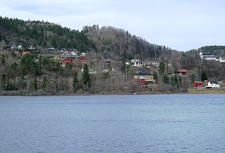
Gjerstad is the administrative centre of Gjerstad municipality in Aust-Agder county, Norway. The village is located at the northern end of the lake Gjerstadvatnet at the northern end of the Norwegian County Road 418. The Sørlandsbanen railway line passes through the village and it stops at the Gjerstad Station. The 0.34-square-kilometre (84-acre) village has a population (2017) of 289 which gives the village a population density of 850 inhabitants per square kilometre (2,200/sq mi). Gjerstad Church is located in the village along with a school and several stores.

Søndeled is a village in Risør municipality in Aust-Agder county, Norway. The village is located at the western end of the Søndeledfjorden at the mouth of the river Brøbøvann. The villages of Fiane and Eikeland lie about 5 kilometres (3.1 mi) to the north, the village of Akland lies about 4.5 kilometres (2.8 mi) to the south, and the town of Risør is about 15 kilometres (9.3 mi) to the southeast.


