
Indre By, also known as Copenhagen Center or K or Downtown Copenhagen, is an administrative district (bydel) in central Copenhagen, the capital of Denmark. It covers an area of 4.65 square kilometres (1.80 sq mi), has a population of 26,223, and a population density of 5,638 per km².

Rosenborg Castle Gardens is the oldest and most visited park in central Copenhagen, Denmark. Established in the early 17th century as the private gardens of King Christian IV's Rosenborg Castle, the park also contains several other historical buildings, including Rosenborg Barracks, home to the Royal Guards, as well as a high number of statues and monuments. The park also holds art exhibitions and other events such as concerts in the summer.

Rosenborg Barracks, one of two barracks of the Royal Danish Life Guard, is located next to Rosenborg Castle in Copenhagen, Denmark. Its address is Gothersgade but it has a long facade along Øster Voldgade.

Gothersgade is a major street in the City Centre of Copenhagen, Denmark. It extends from Kongens Nytorv to Sortedam Lake, passing Rosenborg Castle and Gardens, Nørreport Station and Copenhagen Botanic Gardens on the way.

Vester Voldgade is a street in Copenhagen, Denmark which runs from Jarmers Plads to the waterfront between Frederiksholms Kanal and Langebro, passing the City Hall Square on the way.

Nørre Voldgade is a street in central Copenhagen, Denmark. It runs north-east from Jarmers Plads for approximately 600 metres to Gothersgade where it turns into Øster Voldgade. The succession of Nørre Voldgade, Øster Voldgade and Vester Voldgade together forms a traffic artery which arches around the Zealand side of the central and oldest part of Copenhagen. Nørreport Station, Denmark's busiest railway station, is located in the street.
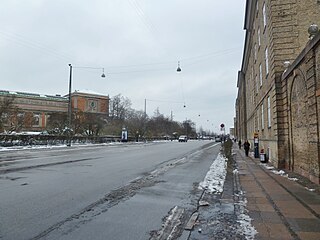
Øster Voldgade, together with Vester Voldgade and Nørre Voldgade, forms a succession of large streets which arches around the central and oldest part of the Zealand side of Copenhagen, Denmark. It runs north-east from Gothersgade at Nørreport Station to Georg Brandes Plads, between the Copenhagen Botanical Gardens and Rosenborg Castle Gardens, and continues straight to a large junction at the southern end of Oslo Plads, near Østerport Station, where it turns into Folke Bernadotte Allé.

Kronprinsessegade is a street in central Copenhagen, Denmark. Noted for its fine Neoclassical houses, it extends from Gothersgade and runs along the southern boundary of Rosenborg Castle Garden, passing Sølvgade and the Nyboder district of old naval barracks before finally joining Øster Voldgade close to Østerport Station. The David Collection, a museum which displays a large collection of Islamic art as well as Danish and European fine and applied arts, is based at No. 30.

Borgergade is a street in central Copenhagen, Denmark. It runs from Gothersgade to Store Kongensgade. As one of relatively few streets in central Copenhagen, the street, in its western part, is dominated by modern buildings. The eastern part passes through the Nyboder district.

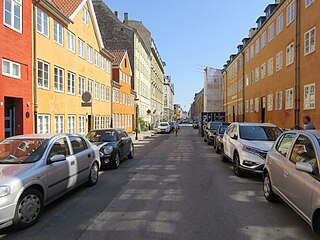
Dronningens Tværgade is a street in central Copenhagen, Denmark, which runs from Bredgade to Rosenborg Castle Garden. The street originally formed a link between the King's Garden and the Queen's Garden. With the Odd Fellows Mansion on Bredgade and the central pavilions of the east fringe of the castle garden located at each their end, the street has axial qualities. These are accentuated by the Dronningegården Estate, a Functionalist housing complex from the 1940s, which forms an urban space around the intersection with Adelgade.

Sølvgade Barracks is a former military facility from 1771 located on the corner of Sølvgade and Øster Voldgade in central Copenhagen, Denmark. The barracks closed in 1926 and the large Baroque complex designed by Nicolas-Henri Jardin then served as headquarters for DSB, the Danish state railways, until 2013, when the building was converted into student apartments.

Klerkegade is a street in central Copenhagen, Denmark. The street runs from Borgergade in the east to Rigensgade in the west, passing Adelgade and Kronprinsessegade on the way.

Stockholmsgade is a mainly residential street in central Copenhagen, Denmark. It follows the northwestern margin of Østre Anlæg, linking Sølvtorvet in the southwest with Oslo Plads at Østerport station in the northeast. The Hirschsprung Collection, an art museum, is located on the street.

Rigensgade is a street in central Copenhagen, Denmark. It links Sølvgade in the west with Øster Voldgade in the east. An underpass for pedestrians link the beginning of the street with Rosenborg Castle Gardens on the other side of Sølvgade. Notable buildings include the former Garrison Hospital. and the Methodist Jerusalem's Church.
Fredericiagade is a street in central Copenhagen, Denmark. It runs from Amaliegade in the south to Rigensgade in the north.

Olfert Fischers Gade is a street in the Nyboder Quarter of central Copenhagen, Denmark and is named after the naval officer Olfert Fischer who commanded the Danish fleet in the Battle of Copenhagen in 1801. It runs from Store Kongensgade in the east to Rigensgade in the west, intersecting the streets Borgergade, Adelgade/Sankt Pauls Plads, Gammelvagt and Kronprinsessegade on the way. The street is closed to through traffic on the west side of Borgergade.
Sankt Pauls Gade is a street in the Nyboder Quarters of central Copenhagen, Denmark. The street passes St. Paul's Church from which it takes its name. The space in front of the church is called Sankt Pauls Plads.

Kronprinsessegade 26 is a Neoclassical property overlooking Rosenborg Castle Garden in central Copenhagen, Denmark. The building was listed on the Danish registry of protected buildings and places in 1932.

Dronningens Tværgade 58 is a Neoclassical property situated close to Rosenborg Castle Garden in central Copenhagen, Denmark. It was built in 1807–08 by Blonms Enke & Sønnder —an equal partnership between a widow and her four mason sons—as the last of their nine buildings constructed with a rate of approximately one building per year. It was listed on the Danish registry of protected buildings and places in 1950.

Thomas Andreas Blom was a Danish master mason, architect and developer who contributed to the rebuilding of Copenhagen in the years after the Copenhagen Fire of 1795 and the Battle of Copenhagen in 1807. He initially worked in a partnership with his mother and three brothers as Bloms Enke & Sønner, constructing approximately one building per year between 1799 and 1808. After being licensed as a master mason in 1810, he continued the work independently. Most of his surviving buildings are listed on the Danish registry of protected buildings and places. He was also active in Copenhagen Fire Corps, reaching the rank of deputy fire chief. He was a driving force behind the foundation of Håndværkerstiftelsen as a charity providing affordable accommodation for old craftsmen and their widows in difficult circumstances.


