Hinlopen Strait is the strait between Spitsbergen and Nordaustlandet in Svalbard, Norway. It is 150 kilometers (93 mi) long and 10 to 60 kilometers wide. The strait is difficult to pass because of pack ice. It is believed to have been named after Thijmen Jacobsz Hinlopen.

Vestfonna is an ice cap located on the western part Nordaustlandet in the Svalbard archipelago in Norway. The glacier covers an area of about 2,500 km2. It is the third largest ice cap in Svalbard and Norway by area, after Austfonna and Olav V Land.

Nordaust-Svalbard Nature Reserve is located in the north-eastern part of the Svalbard archipelago in Norway. The nature reserve covers all of Nordaustlandet, Kong Karls Land, Kvitøya, Sjuøyane, Storøya, Lågøya, Wilhelm Island, Wahlbergøya and a small section of the north-east corner of Spitsbergen. The reserve is 55,354 square kilometres (21,372 sq mi), of which 18,663 square kilometres (7,206 sq mi) is on land and 36,691 square kilometres (14,166 sq mi) is on water—making it the largest preserved area in Norway. It includes the largest glacier in Norway, Austfonna, as well as Vestfonna and parts of Olav V Land. The reserve has been protected since 1 July 1973 and borders in the south to Søraust-Svalbard Nature Reserve.
Bråsvellbreen is a glacier in Nordaustlandet, Svalbard. The glacier is a 45 kilometre long stream southwards from the ice dome Sørdomen of Austfonna, debouching into the sea on the south coast. In the late 1930s it was observed that the glacier had exhibited a recent huge surge, forming a ten kilometre long tongue into the sea.

Orvin Land is the land area of the northeastern part of Nordaustlandet, Svalbard, east of Duvefjorden, including the lower part of Austfonna. The area is named after geologist Anders Kristian Orvin. Orvin Land is bordered by Prins Oscars Land to the east and Austfonna to the south.

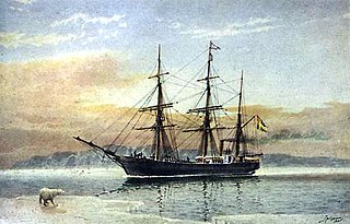
Vegafonna is an ice cap in Gustav Adolf Land on Nordaustlandet in the Svalbard archipelago. It is located on the peninsula Scaniahalvøya, between the bay Palanderbukta to the north and Torellneset to the south. The glacier is named after the vessel SS Vega. Further west on the peninsula is the ice cap Glitnefonna.
Glitnefonna is an ice cap in Gustav Adolf Land on Nordaustlandet in the Svalbard archipelago. It is located on the peninsula Scaniahalvøya, west of the glacier Vegafonna, between the bay Palanderbukta to the northeast and Hinlopen Strait to the southwest. The glacier is named after the god hall Glitnir from Norse mythology.
Palanderbukta is a fjord or bay in Gustav Adolf Land at Nordaustlandet, Svalbard, a southern bay of Wahlenbergfjorden. The bay is named after Swedish naval officer Louis Palander.
Svartknausflya is a coastal plain in Gustav Adolf Land in Nordaustlandet, Svalbard. The length of the plain is about 21 kilometers. West of the plain is Rosenthalbreen, and to the east is Vibebukta and Bråsvellbreen.
Isispynten is the most eastern point of Isisøyane, east of Nordaustlandet, Svalbard. It was earlier regarded as a headland of Nordaustlandet, but after the retreat of Austfonna, it became apparent that the point was on a separate small island.
Isisøyane is a group of small islands east of Nordaustlandet, Svalbard. They were earlier regarded to be part of Nordaustlandet, an ice free point named Isispynten. After the retreat of Austfonna, the islands appeared as islands. They were named Isisøyane in 2009.
Oxfordhalvøya is a peninsula in Wahlenbergfjorden at the southwestern side of Nordaustlandet, Svalbard. It is located between Bodleybukta and Etonbreen at the head of the fjord. The bay Kløverbladbukta cuts into the peninsula, and its highest point is Carfaxhaugen at 103 m.a.s.l.
Bragebreen is a glacier at Nordaustlandet, Svalbard. It is located at the mouth of Wahlenbergfjorden between the headlands of Brageneset and Idunneset. Bragebreen is a glacier stream from the large icecap Vestfonna.
Rosenthalbreen is a glacier in Gustav Adolf Land in Nordaustlandet, Svalbard. It is named after German shipowner and expedition organizer Friedrich Wilhelm Albert Rosenthal. The glacier is an outlet from Vegafonna. It borders to the coastal plain of Svartknausflya, and drains into the sea east of Torellneset, into the bay Ulvebukta of Hinlopen Strait.
Perthesøya is an island at the coast of Gustav V Land at Nordaustlandet, Svalbard. It is located outside Torellneset, in the southern part of Augustabukta. The island is named after a German publishing company.
Norddomen is an ice dome of Austfonna at Nordaustlandet, Svalbard. The glacier cap of Austfonna has two significant ice domes, Norddomen and Sørdomen further south. Norddomen is the highest point of Nordaustlandet, with a height of about 700 m.a.s.l.
Palanderisen is a glaciated area in Gustav Adolf Land at Nordaustlandet, Svalbard. It has an extension of about 35 kilometers and is part of the ice cap of Austfonna, located west of the Sørdomen ice dome, between Etonbreen and Ericadalen. The area is named after Arctic explorer Louis Palander. It includes Sørfonna.
Rijpdalen is a valley in the central part of Nordaustlandet, Svalbard, separating Gustav V Land from Prins Oscars Land. The valley extends between the head of Wahlenbergfjorden and the head of Rijpfjorden. The valley is named after Dutch explorer Jan Rijp. At the watershed in Rijpdalen is the plain of Helvetesflya. The ice caps of Vestfonna and Austfonna are separated by Rijpdalen and Helvetesflya.


