SCAR Southern Ocean Continuous Plankton Recorder Survey

Last updated
Continuous plankton recorder tows conducted in Antarctic waters between 1991 and 2008 (AADC Map 13481) SCARCPRSurvey b GHosie AAD.JPG
Continuous plankton recorder tows conducted in Antarctic waters between 1991 and 2008 (AADC Map 13481)

The SCAR Southern Ocean Continuous Plankton Recorder (SO-CPR) Survey was established in 1991 by the Australian Antarctic Division,of Environment, Water Heritage and the Arts, to map the spatial-temporal patterns of zooplankton and then to use the sensitivity of plankton to environmental change as early warning indicators of the health of the Southern Ocean. It also serves as reference for other Southern Ocean and Antarctic monitoring programs.

Zooplankton Heterotrophic protistan or metazoan members of the plankton ecosystem

Zooplankton are heterotrophic plankton. Plankton are organisms drifting in oceans, seas, and bodies of fresh water. The word zooplankton is derived from the Greek zoon (ζῴον), meaning "animal", and planktos (πλαγκτός), meaning "wanderer" or "drifter". Individual zooplankton are usually microscopic, but some are larger and visible to the naked eye.

Plankton Organisms that live in the water column and are incapable of swimming against a current

Plankton are the diverse collection of organisms that live in large bodies of water and are unable to swim against a current. The individual organisms constituting plankton are called plankters. They provide a crucial source of food to many large aquatic organisms, such as fish and whales.

Southern Ocean The ocean around Antarctica

The Southern Ocean, also known as the Antarctic Ocean or the Austral Ocean, and the "Southern Icy Ocean".</ref> comprises the southernmost waters of the World Ocean, generally taken to be south of 60° S latitude and encircling Antarctica. As such, it is regarded as the fourth-largest of the five principal oceanic divisions: smaller than the Pacific, Atlantic, and Indian Oceans but larger than the Arctic Ocean. This ocean zone is where cold, northward flowing waters from the Antarctic mix with warmer subantarctic waters.

Several countries collaborate in the survey providing vessels to tow Continuous Plankton Recorders (CPRs) in a near circum-Antarctic survey. Tows conducted between Hobart and the French Antarctic station Dumont d’Urville are also conducted in collaboration with the IMOS Australian Continuous Plankton Recorder Survey. The SO-CPR Survey is supported by the Scientific Committee on Antarctic Research and its Expert Group on Continuous Plankton Research, which helps promote and develop the survey.

The Continuous Plankton Recorder (CPR) Survey is one of the longest running marine biological monitoring programmes in the world. Started in 1931 by Sir Alister Hardy and Sir Cyril Lucas, the Survey has provided marine scientists with their only measure of plankton communities on a pan-oceanic scale. Today the CPR Survey is operated by the Marine Biological Association(MBA), located in Plymouth, UK. Uniquely, the CPR Survey’s methods of sampling and plankton analysis remain unchanged since 1948, providing a spatio-temporally comprehensive > 60 year record of marine plankton dynamics.

Antarctic region around the Earths South Pole

The Antarctic is a polar region around the Earth's South Pole, opposite the Arctic region around the North Pole. The Antarctic comprises the continent of Antarctica, the Kerguelen Plateau and other island territories located on the Antarctic Plate or south of the Antarctic Convergence. The Antarctic region includes the ice shelves, waters, and all the island territories in the Southern Ocean situated south of the Antarctic Convergence, a zone approximately 32 to 48 km wide varying in latitude seasonally. The region covers some 20 percent of the Southern Hemisphere, of which 5.5 percent is the surface area of the Antarctic continent itself. All of the land and ice shelves south of 60°S latitude are administered under the Antarctic Treaty System. Biogeographically, the Antarctic ecozone is one of eight ecozones of the Earth's land surface.

Hobart City in Tasmania, Australia

Hobart is the capital and most populous city of the Australian island state of Tasmania. With a population of approximately 225,000, it is the least populated Australian state capital city, and second smallest if territories are taken into account. Founded in 1804 as a British penal colony, Hobart, formerly known as Hobart Town or Hobarton, is Australia's second oldest capital city after Sydney, New South Wales. Prior to British settlement, the Hobart area had been occupied for possibly as long as 35,000 years, by the semi-nomadic Mouheneener tribe, a sub-group of the Nuennone, or South-East tribe. The descendants of these Aboriginal Tasmanians often refer to themselves as 'Palawa'.

The CPRs are towed from research and supply vessels. The CPR is towed at about 10 metres below the surface and for about 450 nautical miles (830 km) per tow. The plankton enters a small opening in the device and is trapped and preserved between two layers of silk mesh. These vessels also collect at the same time underway data such as sea surface temperature, salinity, fluorometry, light and other oceanographic-meteorological parameters. All plankton in five nautical mile (9 km) equivalent sections are identified to the lowest possible taxa, usually species and counted. Antarctic krill and other euphausiids are identified to developmental stage. Plankton counts are combined with averaged environmental data for each 5-nautical-mile (9.3 km).

Sea surface temperature Water temperature close to the oceans surface

Sea surface temperature (SST) is the water temperature close to the ocean's surface. The exact meaning of surface varies according to the measurement method used, but it is between 1 millimetre (0.04 in) and 20 metres (70 ft) below the sea surface. Air masses in the Earth's atmosphere are highly modified by sea surface temperatures within a short distance of the shore. Localized areas of heavy snow can form in bands downwind of warm water bodies within an otherwise cold air mass. Warm sea surface temperatures are known to be a cause of tropical cyclogenesis over the Earth's oceans. Tropical cyclones can also cause a cool wake, due to turbulent mixing of the upper 30 metres (100 ft) of the ocean. SST changes diurnally, like the air above it, but to a lesser degree. There is less SST variation on breezy days than on calm days. In addition, ocean currents such as the Atlantic Multidecadal Oscillation (AMO), can effect SST's on multi-decadal time scales, a major impact results from the global thermohaline circulation, which affects average SST significantly throughout most of the world's oceans.

Salinity The proportion of salt dissolved in a body of water

Salinity is the saltiness or amount of salt dissolved in a body of water, called saline water. This is usually measured in . Salinity is an important factor in determining many aspects of the chemistry of natural waters and of biological processes within it, and is a thermodynamic state variable that, along with temperature and pressure, governs physical characteristics like the density and heat capacity of the water.

Antarctic krill Euphausia superba

Antarctic krill is a species of krill found in the Antarctic waters of the Southern Ocean. It is a small, swimming crustacean that lives in large schools, called swarms, sometimes reaching densities of 10,000–30,000 individual animals per cubic metre. It feeds directly on minute phytoplankton, thereby using the primary production energy that the phytoplankton originally derived from the sun in order to sustain their pelagic life cycle. It grows to a length of 6 centimetres (2.4 in), weighs up to 2 grams (0.071 oz), and can live for up to six years. It is a key species in the Antarctic ecosystem and is, in terms of biomass, probably the most abundant animal species on the planet.

Preparing the CPR on board TS Umitaka Maru (Graham Hosie AAD) SCARCPRSurvey a GHosie AAD.JPG
Preparing the CPR on board TS Umitaka Maru (Graham Hosie AAD)

Approximately 40-50 tows are made each year. More than 80 tows were completed in 2007-08 International Polar Year in support of the Census of Antarctic Marine Life. 135,000 nautical miles (250,000 km) of data have been collected since 1991, producing more than 27,000 samples for 200+ taxa coupled with environmental data. Most data comes from the October to April period. Few ships operate in the region during winter but some winter tows south of Australia have been made.

Use of the SO-CPR data for research purposes is encouraged. Data are made available soon after the CPR samples are processed. Data are held at the Australian Antarctic Data Centre and at the SCAR Marine Biodiversity Information Network.

Related Research Articles

Woods Hole Oceanographic Institution research institute

The Woods Hole Oceanographic Institution is a private, nonprofit research and higher education facility dedicated to the study of marine science and engineering. Its agenda includes: geological activity deep within the earth; plant, animal, and microbial populations and their interactions in the ocean; coastal erosion; ocean circulation; ocean pollution; and global climate change.

A research vessel is a ship or boat designed, modified, or equipped to carry out research at sea. Research vessels carry out a number of roles. Some of these roles can be combined into a single vessel but others require a dedicated vessel. Due to the demanding nature of the work, research vessels are often constructed around an icebreaker hull, allowing them to operate in polar waters.

NOAAS <i>Ronald H. Brown</i> (R 104) ship

NOAAS Ronald H. Brown is a blue-water research vessel of the U.S. National Oceanic and Atmospheric Administration, she is NOAA's only Global-Class research ship.

The Naval Oceanographic Office (NAVOCEANO), located at John C. Stennis Space Center in south Mississippi, comprises approximately 1,000 civilian, military and contract personnel responsible for providing oceanographic products and services to all elements within the Department of Defense.

Maria Klenova Russian and Soviet marine geologist

Maria Vasilyevna Klenova was a Russian and Soviet marine geologist and one of the founders of Russian marine science and contributor to the first Soviet Antarctic atlas.

CalCOFI

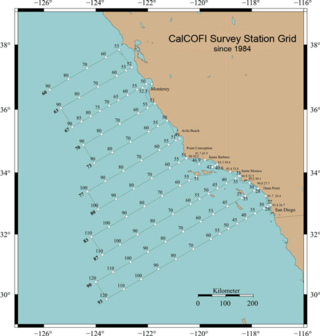
CalCOFI is a multi-agency partnership formed in 1949 to investigate the collapse of the sardine population off California. The organization's members are from NOAA Fisheries Service, Scripps Institution of Oceanography, and California Department of Fish and Wildlife. The scope of this research has evolved into the study of marine ecosystems off California and the management of its fisheries resources. In 2004, the CalCOFI survey area became one of 26 LTER research sites. This time-series of oceanographic and fisheries data allows scientists to assess the human impact and effects of climate change on the coastal ocean ecosystem. CalCOFI hydrographic & biological data, publications, and web information are distributed for use without restriction under the terms of the GNU Free Documentation License.

Australian Continuous Plankton Recorder Survey

The Australian Continuous Plankton Recorder (AusCPR) survey is a joint project of the CSIRO and the Australian Antarctic Division, DEWHA, to monitor plankton communities as a guide to the health of Australia's oceans.

ORV Sagar Nidhi

ORV Sagar Nidhi is an ice-strengthened multidisciplinary vessel operated by the National Institute of Ocean Technology, India. It was constructed at Fincantieri, Italy. The 104 metre long vessel has fully automatic diesel-electric propulsion equipped with dynamic positioning system, azimuth thrusters, and a winch to hoist 60 tonnes from a depth of 6,000 metres.

NOAAS <i>Discoverer</i> (R 102)

NOAAS Discoverer, originally USC&GS Discoverer, was an American Oceanographer-class oceanographic research vessel in service in the United States Coast and Geodetic Survey from 1966 to 1970 and in the National Oceanic and Atmospheric Administration (NOAA) from 1970 to 1996.

NOAAS <i>Henry B. Bigelow</i> (R 225)

NOAAS Henry B. Bigelow is a fisheries research vessel operated by the United States' National Oceanic Atmospheric Administration (NOAA). She is the second in a class of five new fisheries research vessels. She is named after Henry Bryant Bigelow (1879-1967), the American oceanographer, zoologist, and marine biologist who founded of the Woods Hole Oceanographic Institution in Woods Hole, Massachusetts.

NOAAS <i>Bell M. Shimada</i> (R 227)

NOAAS Bell M. Shimada is an American fisheries research ship in commission with the National Oceanic and Atmospheric Administration (NOAA) since 2010. She operates along the United States West Coast.

A video plankton recorder (VPR) is towed underwater video microscope system, which photographs small to fine-scale structure of plankton, from 50 micrometers and up to a few centimeters in size. A VPR consists of five general components: cameras, strobe, additive sensor and flight control, underwater platform and interface software for plankton identification.

NOAAS <i>Reuben Lasker</i> (R 228)

NOAAS Reuben Lasker is a National Oceanic and Atmospheric Administration (NOAA) fishery research vessel. The ship's namesake, Reuben Lasker, was a fisheries biologist who served with the Southwest Fisheries Center, National Marine Fisheries Service, and taught at the Scripps Institution of Oceanography. This class of NOAA ships is very similar to, and based in part upon, the Neil Armstrong-class Oceanographic Research (AGOR) ships owned by the Office of Naval Research and operated by various US Universities.

Ichthyoplankton The eggs and larvae of fish that drift in the water column

Ichthyoplankton are the eggs and larvae of fish. They are mostly found in the sunlit zone of the water column, less than 200 metres deep, which is sometimes called the epipelagic or photic zone. Ichthyoplankton are planktonic, meaning they cannot swim effectively under their own power, but must drift with the ocean currents. Fish eggs cannot swim at all, and are unambiguously planktonic. Early stage larvae swim poorly, but later stage larvae swim better and cease to be planktonic as they grow into juveniles. Fish larvae are part of the zooplankton that eat smaller plankton, while fish eggs carry their own food supply. Both eggs and larvae are themselves eaten by larger animals.

Fishery Oceanographic Research Vessel Sagar Sampada is an Indian research vessel that is equipped to carry out multidisciplinary research in oceanography, marine biology and fishery science. The vessel is currently managed and operated by the Centre for Marine Living Resources & Ecology (CMLRE), Kochi, a research institute under the Ministry of Earth Sciences, Government of India, and is operated from Kochi. FORV Sagar Sampada is a platform for interdisciplinary expeditions in and around the Indian Exclusive Economic Zone, with participation from various institutions, from India and abroad.

NOAAS <i>David Starr Jordan</i> (R 444)

NOAAS David Starr Jordan was an American fisheries research vessel that was in commission in the National Oceanic and Atmospheric Administration (NOAA) fleet from 1970 to 2010. Prior to her NOAA career, she was in the United States Fish and Wildlife Service's Bureau of Commercial Fisheries fleet from 1966 to 1970 as BCF David Starr Jordan.

NOAAS <i>Pisces</i> (R 226)

NOAAS Pisces is an American fisheries and oceanographic research vessel in commission in the National Oceanic and Atmospheric Administration (NOAA) fleet since 2009.

The North South Atlantic Training Transect (NoSoAT) is a program that was developed by the Alfred Wegener Institute (AWI), the Strategic Marine Alliance for Research and Training (SMART), and the Partnership for Observation of the Global Oceans (POGO) in order to further the education and practical training of postgraduate students in climate and marine sciences. Each year, about 30 students are selected through a rigorous application process to join a voyage from Bremerhaven, Germany to Cape Town, South Africa aboard the RV Polarstern. The month-long course is designed to provide students with relevant lectures and projects, as well as provide them with hands-on training for the use of atmospheric and oceanographic equipment and the opportunity to learn about data processing and analysis.

NOAAS <i>George B. Kelez</i> (R 441)

NOAAS George B. Kelez, previously NOAAS George B. Kelez, was an American research vessel in commission in the National Oceanic and Atmospheric Administration (NOAA) fleet from 1972 to 1980. Prior to her NOAA career, she operated under the United States Fish and Wildlife Service′s Bureau of Commercial Fisheries from 1962 to 1970 and the National Marine Fisheries Service from 1970 to 1972 as R/V George B. Kelez.

References