The protected areas of South Africa include national parks and marine protected areas managed by the national government, public nature reserves managed by provincial and local governments, and private nature reserves managed by private landowners. Most protected areas are intended for the conservation of flora and fauna. National parks are maintained by South African National Parks (SANParks). A number of national parks have been incorporated in transfrontier conservation areas.

The Drakensberg is the name given to the eastern portion of the Great Escarpment, which encloses the central Southern African plateau. The Great Escarpment reaches its greatest elevation in this region – 2,000 to 3,482 metres. It is located within the borders of South Africa and Lesotho.

The Highveld is the portion of the South African inland plateau which has an altitude above roughly 1500 m, but below 2100 m, thus excluding the Lesotho mountain regions to the south-east of the Highveld. It is home to some of the country's most important commercial farming areas, as well as its largest concentration of metropolitan centres, especially the Gauteng conurbation, which accommodates one-third of South Africa's population.
The Blyde River Canyon, officially the Motlatse Canyon is a significant natural feature of South Africa, located in Mpumalanga, and forming the northern part of the Drakensberg escarpment. Located in the Blyde River Canyon Nature Reserve, it is 25 kilometres (16 mi) in length and is, on average, around 750 metres (2,461 ft) deep. The Blyderivierpoort Dam, when full, is at an altitude of 665 metres (2,182 ft). The canyon consists mostly of red sandstone. The highest point of the canyon, Mariepskop, is 1,944 metres (6,378 ft) above sea level, whilst its lowest point where the river leaves the canyon is slightly less than 561 metres (1,841 ft) above sea level. This means that by some measure the canyon is 1,383 metres (4,537 ft) deep.

Ngwenya is a town in western Eswatini, lying near the border with South Africa, north west of Mbabane, on the MR3 road. The South African town opposite Ngwenya is Oshoek in Mpumalanga province.

The Timbavati Game Reserve is located at the border line between Hoedspruit in (Limpopo) and Acornhoek in (Mpumalanga), north of the Sabi Sands Private Game Reserve on the western edge of Kruger National Park. Geographically and politically, Timbavati is located in Mpumalanga Province. In Xitsonga, the name 'Timbavati' means "the place where something sacred came down to Earth from the Heavens", and refers to the rare white lions of Timbavati.

South African National Parks (SANParks) is the body responsible for managing South Africa's national parks. SANParks was formed in 1926, and currently manages 21 parks consisting of 3,751,113 hectares (37,511.13 km2), over 3% of the total area of South Africa.
The Mpumalanga Tourism and Parks Agency (MTPA) Board is a governmental organisation responsible for maintaining wilderness areas and public nature reserves in Mpumalanga Province, South Africa.

Blyde River Canyon Nature Reserve is situated in the Drakensberg escarpment region of eastern Mpumalanga, South Africa. The reserve protects the Blyde River Canyon, including sections of the Ohrigstad and Blyde Rivers and the geological formations around Bourke's Luck Potholes, where the Treur River tumbles into the Blyde below. Southwards of the canyon, the reserve follows the escarpment, to include the Devil's and God's Window, the latter a popular viewpoint to the lowveld at the reserve's southern extremity.

Loskop Dam Nature Reserve is situated in northern Mpumalanga province, South Africa. The reserve covers approximately 22,850 ha, if the approximately 2,350 ha surface area of the reservoir is included. The Reserve is situated in the Olifants River valley, about 55 km north of Middelburg, and comprises a hilly bushveld region, centered on the Loskop reservoir.
Mkhombo Nature Reserve is a protected area in Mpumalanga, South Africa.
Ohrigstad Dam Nature Reserve Mpumalanga, Situated on the edge of the highveld plateau, the Ohrigstad Dam Nature Reserve covers an area of 2,400 ha around the dam which impounds a stretch of the Ohrigstad River.

Songimvelo Game Reserve is a provincial park managed by the Mpumalanga Parks Board in Mpumalanga, South Africa. Singimvelo is a plural word that means, we are conserving nature in the siSwati language.

Verloren Valei Nature Reserve is a protected area in Mpumalanga, South Africa. One of the few places in the country to breed the three species cranes present in South Africa, the Verloren Vallei Nature Reserve lies roughly 13 km (8.1 mi) outside Dullstroom, a beautiful, peaceful part of the Steenkampsberg plateau that includes rolling grasslands and sensitive wetlands.
Nooitgedacht Dam Nature Reserve is a park near Carolina in Mpumalanga, South Africa, situated on the Komati River.

Ulusaba Private Game Reserve, owned by Sir Richard Branson as part of the Virgin Limited Edition luxury property portfolio, consists of about 13,500 ha of land set in the heart of the Sabi Sand Private Game Reserve. This private game reserve borders on the sprawling Kruger National Park in South Africa's Mpumalanga province and is home to an abundance of wildlife. Ulusaba means fearful in the local Tsonga Shangaan language and it was a name given to the Sabie River by the Shangaan people. The Sabie River was originally called Ulusaba by the Shangaan simply because there was once a large concentration of dangerous Nile crocodile in the river, hence Ulusaba. Before the establishment of the Kruger National Park, Ulusaba was once a home of Tsonga Shangaan people, the Shangaan were evicted from this land when the Kruger National Park was established and were relocated in nearby villages adjacent Ulusaba Private Game Reserve.

The Blyde River, Motlatse River, or Umdhlazi River is a river in the Mpumalanga and Limpopo provinces of South Africa. It has a northwards course in steep-sided valleys and ravines of the Mpumalanga Drakensberg, before it enters the lowveld region of the Limpopo province. It has its ultimate origins at around 2,000 m altitude in the Hartebeesvlakte conservation area, to the north of Long Tom Pass. It runs through the Blyde River Canyon.

Ohrigstad River is located in Mpumalanga, South Africa. The Ohrigstad River joins the Blyde River at the Blyderivierpoort Dam in the Blyde River Canyon Nature Reserve. Like the Blyde, it has its ultimate origin at around 2,000 m altitude to the south, on the verge of the Hartebeesvlakte conservation area, but follows a more westerly course.

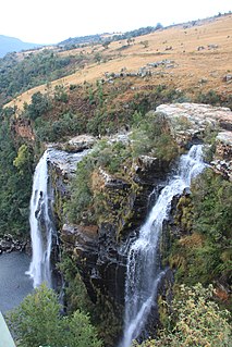
The Lisbon Falls are falls in the Lisbon Creek, a right bank tributary of the Blyde River. They are situated a short distance north of Graskop beside the R532 road, and are the highest waterfalls in Mpumalanga, South Africa. The waterfalls are 94 metres (308 ft) high and were named for the capital city of Portugal.


