Saar-Nahe Hills

Last updated

The Saar-Nahe Hills [1] or Saar-Nahe Uplands [2] (German : Saar-Nahe-Bergland or Saar-Nahe-Berg- und Hügelland) is a major natural region (major landscape unit group, level 3) in the German states of Rhineland-Palatinate and the Saarland. The region of hills and mountains covers an area of 4,185 km² [3] (including the Sobernheim Valley) running from Saarbrücken, Kaiserslautern and the Palatine Forest in the south to the Hunsrück in the northeast. It contains the catchment area of the Nahe as far as Bad Kreuznach as well as small sections of the Middle Saar in the west.

German language West Germanic language

German is a West Germanic language that is mainly spoken in Central Europe. It is the most widely spoken and official or co-official language in Germany, Austria, Switzerland, South Tyrol (Italy), the German-speaking Community of Belgium, and Liechtenstein. It is also one of the three official languages of Luxembourg and a co-official language in the Opole Voivodeship in Poland. The languages which are most similar to German are the other members of the West Germanic language branch: Afrikaans, Dutch, English, the Frisian languages, Low German/Low Saxon, Luxembourgish, and Yiddish. There are also strong similarities in vocabulary with Danish, Norwegian and Swedish, although those belong to the North Germanic group. German is the second most widely spoken Germanic language, after English.

Natural region region distinguished by its common natural features of geography, geology, and climate

A natural region is a basic geographic unit. Usually it is a region which is distinguished by its common natural features of geography, geology, and climate.

Rhineland-Palatinate State in Germany

Rhineland-Palatinate is a state of Germany.

Contents

Location and boundaries

The Saar-Nahe Hills are located between the Hunsrück to the north-northwest, the Lower Naheland to the north, the Alzey Hills to the east-northeast (northwest edge of the Upper Rhine Plain, the Palatine Forest to the south and the Palatine-Saarland Muschelkalk Region to the west-southwest, the last-named lying on French soil in places.

Hunsrück low mountain range in Germany

The Hunsrück is a low mountain range in Rhineland-Palatinate, Germany. It is bounded by the river valleys of the Moselle (north), the Nahe (south), and the Rhine (east). The Hunsrück is continued by the Taunus mountains on the eastern side of the Rhine. In the north behind the Moselle it is continued by the Eifel. To the south of the Nahe is the Palatinate region.

Naheland

The Naheland is the landscape on either side of the river Nahe in the German state of Rhineland-Palatinate.

The Alzey Hills form a region of low, rolling hills, or Hügelland, 275 km² in area and up to 337 m above sea level (NHN), in Rhenish Hesse in the German state of Rhineland-Palatinate. From a natural region perspective they are part of the Upper Rhine Plain and classed as major unit no. 227.

It includes the river valleys of the Middle Saar in the southwest via Prims, Blies, Glan and Alsenz as far as the Lower Nahe to the northeast.

Saar (river) river in France and Germany

The Saar is a river in northeastern France and western Germany, and a right tributary of the Moselle. It rises in the Vosges mountains on the border of Alsace and Lorraine and flows northwards into the Moselle near Trier. It has two headstreams, that both start near Mont Donon, the highest peak of the northern Vosges. After 246 kilometres (153 mi) the Saar flows into the Moselle at Konz (Rhineland-Palatinate) between Trier and the Luxembourg border. It has a catchment area of 7,431 square kilometres (2,869 sq mi).

Prims river in Germany

The Prims is a 91 km long river in western Germany, right tributary of the Saar River. It rises in the Hunsrück mountains, near the village Malborn. It flows generally south through the towns Nonnweiler, Wadern and Schmelz. It flows into the Saar in Dillingen.

Blies river

The Blies is a right tributary of the Saar in southwestern Germany (Saarland) and northeastern France (Moselle). The Blies flows from three springs in the Hunsrück near Selbach, Germany. It is roughly 100 km long, ending in the French city of Sarreguemines. It flows through Sankt Wendel, Ottweiler, Neunkirchen, Bexbach, Homburg and Blieskastel. Its lower extent demarcates part of the Franco–German border.

The largest town in the interior of the landscape is Idar-Oberstein in the north. Others include Kusel and St. Wendel in the centre and Birkenfeld nears its northeastern perimeter.

Idar-Oberstein Place in Rhineland-Palatinate, Germany

Idar-Oberstein is a town in the Birkenfeld district in Rhineland-Palatinate, Germany. As a Große kreisangehörige Stadt, it assumes some of the responsibilities that for smaller municipalities in the district are assumed by the district administration. Today's town of Idar-Oberstein is the product of two rounds of administrative reform, one in 1933 and the other in 1969, which saw many municipalities amalgamated into one. The various Stadtteile have, however, retained their original identities, which, aside from the somewhat more urban character encountered in Idar and Oberstein, tend to hearken back to each centre's history as a rural village. Idar-Oberstein is known as a gemstone town, and also as a garrison town. It is also the largest town in the Hunsrück and has a population of 32,001.

Kusel Place in Rhineland-Palatinate, Germany

Kusel, until 1865 written Cusel, is a town in the Kusel district in Rhineland-Palatinate, Germany. It is the seat of the Kusel-Altenglan Verbandsgemeinde and is also the district seat.

Considerably larger are the cities of Saarbrücken and Kaiserslautern on its southern edge; Bad Kreuznach on the northern side is also worthy of mention. Kirchheimbolanden lies to the east on the far side of it.

Saarbrücken Place in Saarland, Germany

Saarbrücken is the capital and largest city of the state of Saarland, Germany. Saarbrücken is Saarland's administrative, commercial and cultural centre and is next to the French border.

Kaiserslautern Place in Rhineland-Palatinate, Germany

Kaiserslautern is a city in southwest Germany, located in the Bundesland (State) of Rhineland-Palatinate (Rheinland-Pfalz) at the edge of the Palatinate Forest (Pfälzerwald). The historic centre dates to the 9th century. It is 459 kilometres from Paris, 117 km from Frankfurt am Main, and 159 km from Luxembourg.

Bad Kreuznach Place in Rhineland-Palatinate, Germany

Bad Kreuznach is a town in the Bad Kreuznach district in Rhineland-Palatinate, Germany. It is a spa town most well known for its medieval bridge dating from around 1300, the Alte Nahebrücke, which is one of the few remaining bridges in the world with buildings on it.


Related Research Articles

Bad Kreuznach (district) District in Rhineland-Palatinate, Germany

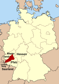
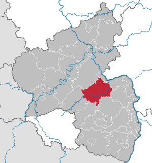
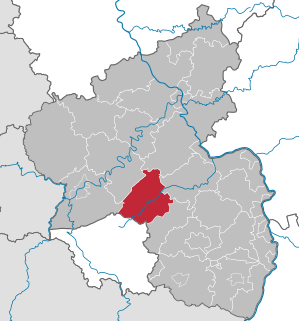
Bad Kreuznach is a district in Rhineland-Palatinate, Germany. It is bounded by the districts of Rhein-Hunsrück, Mainz-Bingen, Alzey-Worms, Donnersbergkreis, Kusel and Birkenfeld.

Birkenfeld (district) District in Rhineland-Palatinate, Germany

Birkenfeld is a district (Landkreis) in Rhineland-Palatinate, Germany. Its seat is the town of Birkenfeld. It is bounded by the districts of Sankt Wendel (Saarland), Trier-Saarburg, Bernkastel-Wittlich, Rhein-Hunsrück, Bad Kreuznach and Kusel.

Nahe (Rhine) tributary of Rhine river

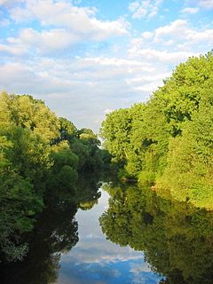
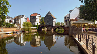
The Nahe is a river in Rhineland-Palatinate and Saarland, Germany, a left tributary to the Rhine. It has also given name to the wine region Nahe situated around it.

Berglangenbach Place in Rhineland-Palatinate, Germany

Berglangenbach is an Ortsgemeinde – a municipality belonging to a Verbandsgemeinde, a kind of collective municipality – in the Birkenfeld district in Rhineland-Palatinate, Germany. It belongs to the Verbandsgemeinde of Baumholder, whose seat is in the like-named town.

Sankt Katharinen, Bad Kreuznach Place in Rhineland-Palatinate, Germany

Sankt Katharinen is an Ortsgemeinde – a municipality belonging to a Verbandsgemeinde, a kind of collective municipality – in the Bad Kreuznach district in Rhineland-Palatinate, Germany. It belongs to the Verbandsgemeinde of Rüdesheim, whose seat is in the municipality of Rüdesheim an der Nahe.

Buhlenberg Place in Rhineland-Palatinate, Germany

Buhlenberg is an Ortsgemeinde – a municipality belonging to a Verbandsgemeinde, a kind of collective municipality – in the Birkenfeld district in Rhineland-Palatinate, Germany. It belongs to the Verbandsgemeinde of Birkenfeld, whose seat is in the like-named town.

Elchweiler Place in Rhineland-Palatinate, Germany

Elchweiler is an Ortsgemeinde – a municipality belonging to a Verbandsgemeinde, a kind of collective municipality – in the Birkenfeld district in Rhineland-Palatinate, Germany. It belongs to the Verbandsgemeinde of Birkenfeld, whose seat is in the like-named town.

Ellweiler Place in Rhineland-Palatinate, Germany

Ellweiler is an Ortsgemeinde – a municipality belonging to a Verbandsgemeinde, a kind of collective municipality – in the Birkenfeld district in Rhineland-Palatinate, Germany. It belongs to the Verbandsgemeinde of Birkenfeld, whose seat is in the like-named town.

Hattgenstein Place in Rhineland-Palatinate, Germany

Hattgenstein is an Ortsgemeinde – a municipality belonging to a Verbandsgemeinde, a kind of collective municipality – in the Birkenfeld district in Rhineland-Palatinate, Germany. It belongs to the Verbandsgemeinde of Birkenfeld, whose seat is in the like-named town.

Kronweiler Place in Rhineland-Palatinate, Germany

Kronweiler is an Ortsgemeinde – a municipality belonging to a Verbandsgemeinde, a kind of collective municipality – in the Birkenfeld district in Rhineland-Palatinate, Germany. It belongs to the Verbandsgemeinde of Birkenfeld, whose seat is in the like-named town.

Mörschied Place in Rhineland-Palatinate, Germany

Mörschied is an Ortsgemeinde – a municipality belonging to a Verbandsgemeinde, a kind of collective municipality – in the Birkenfeld district in Rhineland-Palatinate, Germany. It belongs to the Verbandsgemeinde of Herrstein, whose seat is in the like-named municipality.

Schauren Place in Rhineland-Palatinate, Germany

Schauren is an Ortsgemeinde – a municipality belonging to a Verbandsgemeinde, a kind of collective municipality – in the Birkenfeld district in Rhineland-Palatinate, Germany. It belongs to the Verbandsgemeinde of Rhaunen, whose seat is in the like-named municipality.

Soonwald mountains in Germany

The Soonwald is a forested, low mountain region, up to 657.5 m above sea level (NN), which forms part of the Hunsrück mountains in the German Central Uplands. It lies within the counties of Rhein-Hunsrück-Kreis and Bad Kreuznach in the state of Rhineland-Palatinate.

North Palatine Uplands mountains in Germany

The North Palatine Uplands, sometimes incorrectly shortened to Palatine Uplands, is a low mountain range and landscape unit in the German state of Rhineland-Palatinate and belongs mainly to the Palatinate region. It is part of the Saar-Nahe Uplands.

Nahe Valley Railway railway line

The Nahe Valley Railway is a two-track, partially electrified main line railway in the German states of Rhineland-Palatinate and Saarland, which runs for almost 100 kilometres along the Nahe. It was built by the Rhine-Nahe Railway Company and connects Bingen am Rhein on the Left Rhine line with Saarbrücken. It was opened between 1858 and 1860 and is one of the oldest railways in Germany. The section south of Bad Kreuznach is part of the regionally important transport corridor between the two major cities of Mainz and Saarbrücken.

Walking routes in the Palatine Forest

Walking routes in the Palatine Forest fall into two categories. The first are longer walking routes, most of which are maintained by the Palatine Forest Club, or PWV, and which are linked to the national and international network of long distance paths. The second category are those local circular walks and themed walking routes, some of which are of wider regional importance, and which are maintained by municipal authorities. The Palatine Forest, as part of the Palatine Forest-North Vosges Biosphere Reserve, is an important conservation area. As a result, the Palatine Forest, the bunter sandstone landscape of the Palatine Forest Nature Park, the castles in the Dahner Felsenland and the cross-border paths into Alsace and the Vosges make the region particularly popular with ramblers and walkers.

Westrich Plateau

The Westrich Plateau, also Zweibrücken Westrich or Southwest Palatine Plateau, is a landscape in the German state of Rhineland-Palatinate, with small areas also in the Saarland (Saarpfalz-Kreis). Its heart is in the southwest of the Palatinate region and it is part of the historic region of Westrich.

Schwarzwalder Hochwald

The Schwarzwalder Hochwald, not to be confused with the High Black Forest, is the high south-western part of the Hunsrück in the German states of Saarland and Rhineland-Palatinate. The mountains are up to 816.32 m high.

The North French Scarplands is a scarp landscape comprising various highlands and uplands in northern France, eastern Belgium and southern Luxembourg and southwestern Germany. It is separated from the South German Scarplands to the east by the Upper Rhine Graben. To the north it is bounded by the Hunsrück and the Rhenish Massif.

The Landstuhl Marsh or Landstuhl Bog is a region in West Palatinate in the German state of Rhineland-Palatinate.

References

  1. Elkins, T H (1972). Germany (3rd ed.). London: Chatto & Windus, 1972. pp. 213-214. ASIN   B0011Z9KJA.
  2. Dickinson, Robert E (1964). Germany: A regional and economic geography (2nd ed.). London: Methuen, pp. 82-85 and 563. ASIN   B000IOFSEQ.
  3. Emil Meynen, Josef Schmithüsen: Handbuch der naturräumlichen Gliederung Deutschlands. Bundesanstalt für Landeskunde, Remagen/Bad Godesberg 1953–1962 (9 Lieferungen in 8 Büchern, aktualisierte Karte 1:1.000.000 mit Haupteinheiten 1960).

Coordinates: 49°31′19″N7°18′40″E / 49.5220°N 7.3110°E / 49.5220; 7.3110