
Thuringia, officially the Free State of Thuringia, is a state of central Germany, covering 16,171 square kilometres (6,244 sq mi), the sixth smallest of the sixteen German states. It has a population of about 2.1 million.

The Weser is a river of Lower Saxony in north-west Germany. It begins at Hannoversch Münden through the confluence of the Werra and Fulda. It passes through the Hanseatic city of Bremen. Its mouth is 50 km (31 mi) further north against the ports of Bremerhaven and Nordenham. The latter is on the Butjadingen Peninsula. It then merges into the North Sea via two highly saline, estuarine mouths.

The Werra, a river in central Germany, is the right-bank headwater of the Weser. "Weser" is a synonym in an old dialect of German. The Werra has its source near Eisfeld in southern Thuringia. After 293 kilometres (182 mi) the Werra joins the river Fulda in the town of Hann. Münden, forming the Weser. If the Werra is included as part of the Weser, the Weser is the longest river entirely within German territory at 744 kilometres (462 mi).

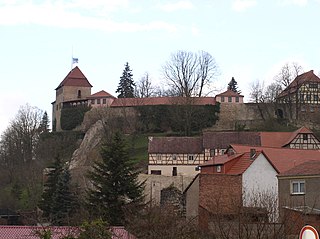
Eisenach is a town in Thuringia, Germany with 42,000 inhabitants, located 50 kilometres west of Erfurt, 70 km southeast of Kassel and 150 km northeast of Frankfurt. It is the main urban centre of western Thuringia and bordering northeastern Hessian regions, situated near the former Inner German border. A major attraction is Wartburg castle, which has been a UNESCO World Heritage Site since 1999.

The Aller is a 215-kilometre-long (134 mi) river in the states of Saxony-Anhalt and Lower Saxony in Germany. It is a right-hand, and hence eastern, tributary of the Weser and is also its largest tributary. Its last 117 kilometres (73 mi) form the Lower Aller federal waterway. The Aller was extensively straightened, widened and, in places, dyked, during the 1960s to provide flood control of the river. In a 20-kilometre-long (12 mi) section near Gifhorn, the river meanders in its natural river bed.

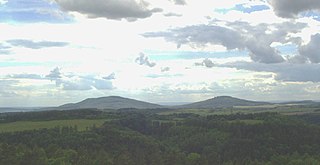
The Thuringian Forest is a mountain range in the southern parts of the German state of Thuringia, running northwest to southeast. Skirting from its southerly source in foothills to a gorge on its north-west side is the Werra valley. On the other side of the Forest is an upper outcrop of the North German Plain, the Thuringian Basin, which includes the city Erfurt. The south and south-east continuation of the range is the highland often called the Thuringian-Vogtlandian Slate Mountains.

The Lahn is a 245.6-kilometre-long (152.6 mi), right tributary of the Rhine in Germany. Its course passes through the federal states of North Rhine-Westphalia (23.0 km), Hesse (165.6 km), and Rhineland-Palatinate (57.0 km).

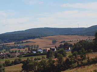
The Rhön Mountains are a group of low mountains in central Germany, located around the border area where the states of Hesse, Bavaria and Thuringia come together. These mountains, which are at the extreme southeast end of the East Hesse Highlands, are partly a result of ancient volcanic activity. They are separated from the Vogelsberg Mountains by the river Fulda and its valley. The highest mountain in the Rhön is the Wasserkuppe, which is in Hesse. The Rhön Mountains are a popular tourist destination and walking area.
Creuzburg is a town and a former municipality on the Werra river in the Wartburgkreis in Thuringia, Germany. Since December 2019, it is part of the town Amt Creuzburg.

The Hörsel is a 56 km (35 mi) long river in Thuringia, Germany, right tributary of the Werra. It is formed by the confluence of two smaller rivers in Leinatal, at the northern edge of the Thuringian Forest. The Hörsel flows generally northwest through the towns Hörselgau, Wutha-Farnroda and Eisenach. It flows into the Werra in Hörschel, a village near Eisenach.

The Selbitz is a river of Bavaria and Thuringia, Germany.
The East Hesse Highlands describes a heavily wooded range of hills lying mainly in the German state of Hesse, but also extending a little way into Lower Saxony to the north, Thuringia to the east and Bavaria to the southeast. The region is sandwiched between the West Hesse Depression to the west, the Weser Uplands to the north, the Thuringian Basin to the northeast, the northwestern edge of the Thuringian Forest to the east, the Spessart to the south and the Wetterau to the southwest.

The Rennsteig is a ridge walk as well as a historical boundary path in the Thuringian Forest, Thuringian Highland and Franconian Forest in Central Germany. The long-distance trail runs for about 170 km from Eisenach and the Werra valley in the northwest to Blankenstein and the Selbitz river in the southeast.
The Weihe river is an 11.5 km long western tributary of the Werra River in the Hersfeld-Rotenburg district in Hesse and the Wartburg district in Thuringia, Germany. It flows into the Werra in Gerstungen.

Felda is a river of Thuringia, Germany. It flows into the Werra in Dorndorf. The main source of the Felda is located immediately south of Erbenhausen am Bergsattel between the Stellberg in the south and the Alten Mark in the north at an altitude of about 510 m; The Herpf rises in the eastern neighborhood. A left source stream, called Rodgraben, rises at about 676 m altitude on the eastern slope of the Ellenbogen and passes the place Reichenhausen immediately above the confluence.

The Ohm Hills are a small range of hills up to 533.4 m above sea level (NN) high and about 50 km² in area. They are part of the Lower Eichsfeld region and are located in the county of Eichsfeld, North Thuringia, Germany.
The Gleichberge, which mainly comprise the Großer and Kleiner Gleichberg, are a small, inselberg-like mountain range, up to 679 m above sea level (NHN), in the southwestern part of the German state of Thuringia. They rise just east of the little ancient town of Römhild in the county of Hildburghausen.

The Salzungen Werra Upland is a natural region in Germany that forms part of the East Hesse Highlands in the German states of Hesse and Thuringia.
The Seulingswald is a hill range in the German Central Uplands which reaches heights of up to 480.3 m above sea level (NHN). It is part of the Fulda-Werra Uplands in the East Hesse Highlands within the Hessian county of Hersfeld-Rotenburg; small ridges extend into the Thuringian county of Wartburgkreis. It is a sandstone range and one of the largest contiguous woodland areas in Hesse.

The Rhön Cycleway is a cycle path in Germany that runs for 180 kilometres from Bad Salzungen to Hammelburg. Its route takes it through 3 states: from Thuringia via Hesse to Bavaria.
