The Saargau was a Frankish Gau county (Gaugrafschaft). Today the name is given to the ridge between the rivers Saar and Moselle in Germany and, in the south, the region between the Saar and the French border.
Contents


The Saargau was a Frankish Gau county (Gaugrafschaft). Today the name is given to the ridge between the rivers Saar and Moselle in Germany and, in the south, the region between the Saar and the French border.
The Saargau was a Frankish gau county that is recorded as early as the 7th century and, at that time, also included that part of the Saar valley which is today in France. In the Treaty of Mersen (870 A.D.) two Saar counties are named: comitatus Sarachuua inferior (Lower Saargau) and comitatur Sarachuua subterior (Upper Saargau), of which only the Lower Saargau continued to bear the name Saargau.
The Saargau is a ridge west of the River Saar. It begins in the south near Berus, runs northwards along the French border, from the Saarland over to the neighbouring state of Rhineland-Palatinate. The northern part is bounded in the west by the Moselle and ends near Konz, where the Saar empties into the Moselle.
The eastern edge of the Saargau, in the Saarland, drops steeply down to the Saar valley. To the west, towards Lorraine and over the Franco-German border, the gau landscape is rather flat and broad with gently rolling hills. Geologically, the Saargau, belongs to the Lorraine Scarplands, which rise every few kilometres from west to east in steep escarpments, the land sloping almost imperceptibly between each pair of escarpments. On the western foothills of the Saargau, in the area of the Moselle, wine is grown. The predominant grape here is the Elbling.
The gau landscape is mainly characterised by heavy muschelkalk soils. In the area of the villages of Borg, Oberleuken, Büschdorf, Eft-Hellendorf, Sinz, Münzingen, Kesslingen and Faha crops are grown and it is described as the breadbasket of the Saarland. This intensively farmed region extends into Rhineland-Palatinate which borders it to the north, especially around the villages of Merzkirchen, Fisch and Mannebach (near Saarburg). In addition, there are meadow orchards everywhere and, immediately around the villages of Tettingen-Butzdorf and Borg commercial fruit is grown. The Viezstraße road runs over the Saargau. The steep hillsides of the eastern foothills of the Saargau that descend towards the Saar are mostly covered in woods. In the northern area around the Saarburg there are also vineyards where the well known Rhineland-Palatine Saar Riesling is grown.
The Saargau reaches heights of around 400 metres above sea level (NN) in the north (Nitteler Höcht 390 m, Helenenkreuz near Wincheringen 413 m); further south it rises to nearly 450 metres (Eiderberg near Freudenburg 440 m, Kewelsberg near Tünsdorf 442 m)
| Wikimedia Commons has media related to Saargau . |

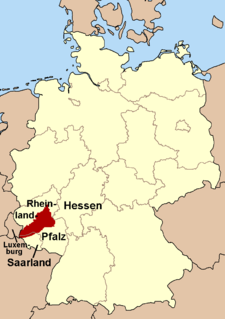
Saarland is a state of Germany in the west of the country. With an area of 2,570 km2 (990 sq mi) and population of 995,600 in 2015, it is the smallest German state in both area and population apart from the city-states of Berlin, Bremen, and Hamburg. Saarbrücken is the state capital and largest city; other cities include Neunkirchen and Saarlouis. Saarland is mainly surrounded by the department of Moselle in France to the west and south and the neighboring state of Rhineland-Palatinate in Germany to the north and east; it also shares a small border about 8 kilometres long with the canton of Remich in Luxembourg to the northwest.
The Rhineland is the name used for a loosely defined area of Western Germany along the Rhine, chiefly its middle section.

The Moselle is a river that rises in the Vosges mountains and flows through north-eastern France, Luxembourg, and western Germany. It is a left bank tributary of the Rhine, which it joins at Koblenz. A small part of Belgium is in its basin as it includes the Sauer and the Our.
The Hunsrück is a long, triangular, pronounced upland in Rhineland-Palatinate, Germany. It is bounded by the valleys of the Moselle-Saar (north-to-west), the Nahe (south), and the Rhine (east). It is continued by the Taunus mountains, past the Rhine and by the Eifel past the Moselle. To the south of the Nahe is a lower, hilly country forming the near bulk of the Palatinate region and all of the, smaller, Saarland. Below its north-east corner is Koblenz.
Merzig-Wadern is a Kreis (district) in the northwest of the Saarland, Germany. Neighboring districts are Trier-Saarburg, Sankt Wendel, Saarlouis, the French département Moselle, and Luxembourg.
Trier-Saarburg is a district in the west of Rhineland-Palatinate, Germany. Neighboring districts are Bitburg-Prüm, Bernkastel-Wittlich, Birkenfeld, Sankt Wendel (Saarland), and Merzig-Wadern (Saarland). To the west it borders Luxembourg. The district-free city Trier is completely surrounded by the district.
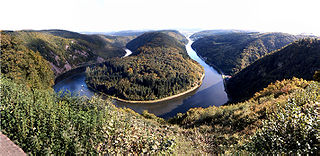
The Saar is a river in northeastern France and western Germany, and a right tributary of the Moselle. It rises in the Vosges mountains on the border of Alsace and Lorraine and flows northwards into the Moselle near Trier. It has two headstreams, that both start near Mont Donon, the highest peak of the northern Vosges. After 246 kilometres (153 mi) the Saar flows into the Moselle at Konz (Rhineland-Palatinate) between Trier and the Luxembourg border. It has a catchment area of 7,431 square kilometres (2,869 sq mi).

Dillingen is a town in the district of Saarlouis, in Saarland. It has about 20,000 inhabitants and is divided into the three districts Dillingen-city center, Pachten and Diefflen. The city is located on the edge of the Saar-Hunsrück Nature Park at the mouth of the Prims in the Saar and is located about 10 km from the French border. Dillingen is located about 60 km from Luxembourg City and Trier, 50 km from Metz and 30 km from Saarbrücken and is directly adjacent to the urban area of Saarlouis. In terms of population, it is the second largest municipality in the district of Saarlouis. The Dillinger Hütte steelworks is located here.

Rehlingen-Siersburg is a municipality in the district of Saarlouis, in Saarland, Germany. It is situated on the river Saar, approx. 8 km northwest of Saarlouis, and 30 km northwest of Saarbrücken.
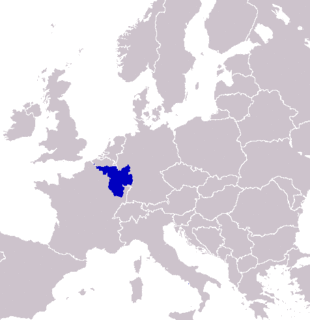
SaarLorLux or Saar-Lor-Lux, a portmanteau of Saarland, Lorraine and Luxembourg, is a euroregion of five regional authorities located in four European states. The term has also been applied to cooperations of several of these authorities or of their subdivisions, administrations, organisations, clubs and people. Member regions represent different political structures: the sovereign state of Luxembourg; Belgium's Walloon region, comprising the French and German speaking parts of Belgium; Lorraine, a region of France; the French départements Moselle and Meurthe-et-Moselle; and the German federated states of Saarland and Rhineland-Palatinate.

Nittel, on the Upper Moselle, is an ortsgemeinde in the Landkreis [county] of Trier-Saarburg in the state of Rhineland-Palatinate. It belongs to the Verbandsgemeinde [United Municipalities] of Konz. The place, located between dolomite and limestone cliffs, is a nationally recognized resort.

The Greater Region of Luxembourg, or simply Greater Region, is a geopolitical region within Europe, created to promote economic, cultural, touristic and social development and cooperation. It occupies an area of 65,401 square kilometres (25,251 sq mi) with Luxembourg at its center and including adjacent regions of Belgium, Germany and France.

Berus is a village in the municipality of Überherrn in the district of Saarlouis, Saarland, southwestern Germany. Until December 1973, Berus was a municipality of its own.

The Thionville–Trier railway connects Thionville in the French region of Grand Est with Trier in the German state of Rhineland-Palatinate. It also passes through the westernmost part of the Saarland along the Moselle for a few kilometres.

The Sickingen Heights form a landscape in the western part of the German state of Rhineland-Palatinate. The region was named after the family of imperial knight, Franz von Sickingen (1481–1523), because most of the area belonged to the territory of the House of Sickingen in the Middle Ages.

The Pays de Bitche is a natural region located in the Moselle department of the Grand Est region of France. It corresponds to the present French part of the former principality of Zweibrücken-Bitsch and to the part of the Northern Vosges that lies within Lorraine.

The Saar-Hunsrück Nature Park was established in 1980 and covers an area of just under 2,000 km² in the German states of Rhineland-Palatinate and the Saarland.
The Palatine-Saarland Muschelkalk Region - or more accurately the Palatine-Saarland-Lorraine Muschelkalk Region - is a natural region of the third order in southwestern Rhineland-Palatinate and southern Saarland in Germany, and, on the French side of the border, in northern Lorraine and Alsace bossue. Its name is derived from the Handbook of the Natural Region Divisions of Germany, where it bears the index number 18.

The Upper Moselle is the name given in Germany to that section of the River Moselle, 45 kilometres long, that runs from the Franco-German-Luxembourg tripoint near Perl to its confluence with the Saar near Konz shortly before Trier. From the tripoint to its confluence with the Sauer, the Upper Moselle forms the border between the German states of the Saarland and Rhineland-Palatinate on the one side and Luxembourg on the other. This stretch of the river known as the Upper Moselle is, however, not the same as the geographical upper reaches of the Moselle, which run from its source near Bussang in the Vosges mountains in Lorraine via Épinal and Nancy roughly as far as Metz.