Freudenburg

Last updated
Freudenburg
Freudenburg1.jpg
DEU Freudenburg COA.svg
Location of Freudenburg within Trier-Saarburg district
Freudenburg in TR.svgBeurenNeuhüttenGreimerathWellenSchöndorfFischFellKennMehringSchleichAachNewel
Germany adm location map.svg
Red pog.svg
Freudenburg
Rhineland-Palatinate location map.svg
Red pog.svg
Freudenburg
Coordinates: 49°32′36″N6°32′01″E / 49.54333°N 6.53361°E / 49.54333; 6.53361
Country Germany
State Rhineland-Palatinate
District Trier-Saarburg
Municipal assoc. Saarburg-Kell
Subdivisions2
Government
   Mayor (201924) Alois Zehren [1]
Area
  Total11.00 km2 (4.25 sq mi)
Elevation
350 m (1,150 ft)
Population
 (2022-12-31) [2]
  Total1,833
  Density170/km2 (430/sq mi)
Time zone UTC+01:00 (CET)
  Summer (DST) UTC+02:00 (CEST)
Postal codes
54450
Dialling codes 06582
Vehicle registration TR
Website www.freudenburg.de

Freudenburg is a municipality in the Trier-Saarburg district, in Rhineland-Palatinate, Germany. Freudenburg is twinned with the village of Appoigny in France.

Contents

Geographical location

The village lies at the foot of the Eiderberg, at an elevation of 439 metres. South of the main town lies the border to the adjacent state of Saarland. Saarburg, the administrative seat of the municipality, is located about seven kilometres north-northeast. The area has a large number of hiking trails and old castle ruins. The village consists of an old town on the higher incline with many structures dating back to early 19th century and a newer conurbation of houses built from around 2005 on the other side of the town, heading towards the valley of Kollesleuken. The oldest structure, the old castle fort, dates back to the early 14th century.

History

In 1337 King John of Bohemia, Count of Luxembourg, built "Freudenburg" at the foot of the Eiderberg, at that time called "Freyding". As part of a castle protectorate between Trier and Luxembourg, it served to secure the Heerstraße Trier-Metz. As early as 1346 Freudenburg was referred to as a "city" in the context of a collective privilege of the Archdiocese. As a small farming town, Freudenburg took over central functions for the surrounding villages. With the purchase of the castle county "Freyding" by the imperial abbey of St. Maximin, the castle was rebuilt. In the dispute between the abbey and Elector Philipp Christoph von Sötern the castle was occupied in 1646 by Trier Archdiocese troops, destroyed and was not rebuilt. The community of Hospitals were assigned the ruins as part of a secularization exercise, which they later sold in 1861 to the local authority. The local authority then carried out restructuring and stabilization of the site in 1908 and again in 1980.

On 18 July 1946 Freudenburg was affiliated with another 80 municipalities across Trier and Saarburg Counties that, earlier, in February 1946 had been separated from the rest of the French occupation zone Saar territory, which was by then no longer under the Allied Control Council . On 6 June 1947 this territorial spin-off was reduced to 21 municipalities. In 1946 Freudenburg joined the newly formed state Rheinland-Pfalz (Rhineland-Palatinate.)

On 7 June 1969 a part of the local authority of Kirf with 101 inhabitants was re-joined to Freudenburg.

Population growth

The development of the population of Freudenburg based on the current municipality, the values from 1871 to 1987 based on censuses: [3]

YearInhabitants
1815676
1835906
1871941
19051.154
19391.358
YearInhabitants
19501.396
19611.533
19701.626
19871.488
20051.496

Local council

The local council in Freudenburg consists of 16 council members, who were elected in the local election on 25 May 2014 in a personalized proportional representation election, and the honorary mayor as chairman.

The distribution of seats in the local council: [4]

Wahl SPD CDU UWF WGR Gesamt
201494316 seats
200994316 seats
200494316 seats

Local sightseeing

Public and sports facilities

Freudenburg has a primary school, a football club as well as a kindergarten and children's playgrounds. For leisure activities there are two tennis courts, a gym and a sports field.

Economy

Construction companies and small businesses (auto-garages, bakery, bistro, hairdressers, large furniture store) as well as service companies characterize the local working life.

Related Research Articles

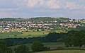
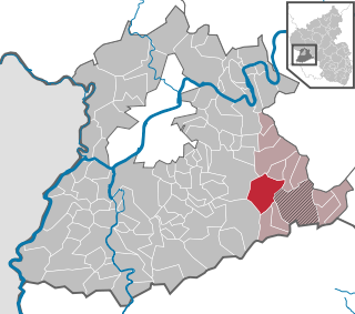
Trier-Saarburg is a district in the west of Rhineland-Palatinate, Germany. Neighboring districts are Bitburg-Prüm, Bernkastel-Wittlich, Birkenfeld, Sankt Wendel (Saarland), and Merzig-Wadern (Saarland). To the west it borders Luxembourg. The district-free city Trier is surrounded by the district.

<span class="mw-page-title-main">Konz</span> Town in Rhineland-Palatinate, Germany

Konz is a city in the Trier-Saarburg district, in Rhineland-Palatinate, Germany. It is situated at the confluence of the rivers Saar and Moselle, approx. 8 km southwest of Trier.

<span class="mw-page-title-main">Trier-Land</span> Verbandsgemeinde in Rhineland-Palatinate, Germany

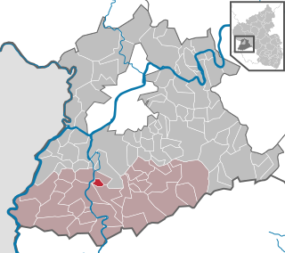
Trier-Land is a Verbandsgemeinde in the Trier-Saarburg district, in Rhineland-Palatinate, Germany. It is situated on the border with Luxembourg, north and west of Trier. The seat of the municipality is in Trier, itself not part of the municipality.

<span class="mw-page-title-main">Schoden</span> Municipality in Rhineland-Palatinate, Germany

Schoden is a municipality in the Trier-Saarburg district, in Rhineland-Palatinate, Germany.

<span class="mw-page-title-main">Reinsfeld</span> Municipality in Rhineland-Palatinate, Germany

Reinsfeld is a municipality in the Trier-Saarburg district, in Rhineland-Palatinate, Germany. It belongs to the municipality of Hermeskeil. Reinsfeld is a state-recognized health resort.

<span class="mw-page-title-main">Kanzem</span> Municipality in Rhineland-Palatinate, Germany

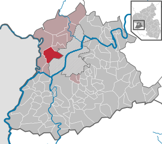
Kanzem is a municipality in the Trier-Saarburg district, in Rhineland-Palatinate, Germany.

<span class="mw-page-title-main">Kirf</span> Municipality in Rhineland-Palatinate, Germany

Kirf is a municipality in the Trier-Saarburg district, in Rhineland-Palatinate, Germany.

<span class="mw-page-title-main">Lampaden</span> Municipality in Rhineland-Palatinate, Germany

Lampaden is a municipality in the Trier-Saarburg district, in Rhineland-Palatinate, Germany. The village is over a thousand years old and acquired grazing rights in the year 1036. The area was already populated in Celtic and Roman times.

<span class="mw-page-title-main">Langsur</span> Municipality in Rhineland-Palatinate, Germany

Langsur is a municipality in the Trier-Saarburg district, in Rhineland-Palatinate, Germany.

<span class="mw-page-title-main">Neuhütten, Rhineland-Palatinate</span> Municipality in Rhineland-Palatinate, Germany

Neuhütten is a municipality in the Trier-Saarburg district, in Rhineland-Palatinate, Germany.

<span class="mw-page-title-main">Nittel</span> Municipality in Rhineland-Palatinate, Germany

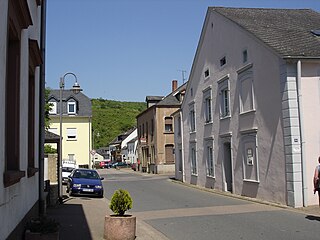
Nittel, on the Upper Moselle, is an Ortsgemeinde in the Landkreis [county] of Trier-Saarburg in the state of Rhineland-Palatinate. It belongs to the Verbandsgemeinde [United Municipalities] of Konz. The place, located between dolomite and limestone cliffs, is a nationally recognized resort.

<span class="mw-page-title-main">Oberbillig</span> Municipality in Rhineland-Palatinate, Germany

Oberbillig is a municipality in the Trier-Saarburg district, in Rhineland-Palatinate, Germany.

<span class="mw-page-title-main">Ockfen</span> Municipality in Rhineland-Palatinate, Germany

Ockfen is a municipality in the Trier-Saarburg district, in Rhineland-Palatinate, Germany.

<span class="mw-page-title-main">Onsdorf</span> Municipality in Rhineland-Palatinate, Germany

Onsdorf is a municipality in the Trier-Saarburg district, in Rhineland-Palatinate, Germany.

<span class="mw-page-title-main">Züsch</span> Municipality in Rhineland-Palatinate, Germany

Züsch is a municipality located in Trier-Saarburg county, in the state of Rhineland-Palatinate, Germany. Züsch is located 40 km from Trier, Germany's oldest city. The Frankfurt-Hahn airport is 40 km away.

<span class="mw-page-title-main">Wincheringen</span> Municipality in Rhineland-Palatinate, Germany

Wincheringen is a municipality in the Trier-Saarburg district, in Rhineland-Palatinate, Germany.

<span class="mw-page-title-main">Palzem</span> Municipality in Rhineland-Palatinate, Germany

Palzem is a municipality in the Trier-Saarburg district, in Rhineland-Palatinate, Germany.

<span class="mw-page-title-main">Wiltingen</span> Municipality in Rhineland-Palatinate, Germany

Wiltingen is a municipality in the Trier-Saarburg district, in Rhineland-Palatinate, Germany.

<span class="mw-page-title-main">Wawern</span> Municipality in Rhineland-Palatinate, Germany

Wawern is a municipality in the Trier-Saarburg district, in Rhineland-Palatinate, Germany.

<span class="mw-page-title-main">Trierweiler</span> Municipality in Rhineland-Palatinate, Germany

Trierweiler is a municipality in the Trier-Saarburg district, in Rhineland-Palatinate, Germany. The name Trierweiler was first mentioned in 1202. Because of the town's close proximity to the Luxembourg border, many residents commute to work in Luxembourg.

References

  1. Direktwahlen 2019, Landkreis Trier-Saarburg, Landeswahlleiter Rheinland-Pfalz, accessed 2 August 2021.
  2. "Bevölkerungsstand 2022, Kreise, Gemeinden, Verbandsgemeinden" (PDF) (in German). Statistisches Landesamt Rheinland-Pfalz. 2023.
  3. Statistisches Landesamt Rheinland-Pfalz - Regionaldaten
  4. Der Landeswahlleiter Rheinland-Pfalz: Kommunalwahl 2014, Stadt- und Gemeinderatswahlen