
Lars von Trier is a Danish film director and screenwriter with a prolific and controversial career spanning more than four decades. His work is known for its genre and technical innovation, confrontational examination of existential, social, and political issues, and his treatment of subjects such as mercy, sacrifice, and mental health.

Rhineland-Palatinate is a western state of Germany. It covers 19,846 km2 (7,663 sq mi) and has about 4.05 million residents. It is the ninth largest and sixth most populous of the sixteen states. Mainz is the capital and largest city. Other cities are Ludwigshafen am Rhein, Koblenz, Trier, Kaiserslautern and Worms. It is bordered by North Rhine-Westphalia, Saarland, Baden-Württemberg and Hesse and by the countries France, Luxembourg and Belgium.

Trier, formerly known in English as Trèves and Triers, is a city on the banks of the Moselle in Germany. It lies in a valley between low vine-covered hills of red sandstone in the west of the state of Rhineland-Palatinate, near the border with Luxembourg and within the important Moselle wine region.

The Moselle is a river that rises in the Vosges mountains and flows from western Germany through Luxembourg,and north-eastern France. It is a left bank tributary of the Rhine, which it joins at Koblenz. A small part of Belgium is in its basin as it includes the Sauer and the Our.
The Eifelkreis Bitburg-Prüm is a district in Rhineland-Palatinate, Germany. It is bounded by Luxembourg, Belgium and the districts of Euskirchen, Vulkaneifel, Bernkastel-Wittlich and Trier-Saarburg.
Trier-Saarburg is a district in the west of Rhineland-Palatinate, Germany. Neighboring districts are Bitburg-Prüm, Bernkastel-Wittlich, Birkenfeld, Sankt Wendel (Saarland), and Merzig-Wadern (Saarland). To the west it borders Luxembourg. The district-free city Trier is completely surrounded by the district.

The University of Trier, in the German city of Trier, was founded in 1473. Closed in 1798 by order of the then French administration in Trier, the university was re-established in 1970 after a hiatus of some 172 years. The new university campus is located on top of the Tarforst heights, an urban district on the outskirts of the city. The university has six faculties with around 470 faculty members. In 2006 around 14,000 students were matriculated, with 43.5% of the student body male and 56.5% female; the percentage of foreign students was approximately 15.5%.

The ADAC Rallye Deutschland is a rally event held in Germany. The event was first held in 1982 and originally hosted by e.g. Frankfurt, Mainz and Koblenz. In 2000, the rally was relocated to the region around Trier. Previously part of the European and German championships, the event has been in the World Rally Championship calendar since the 2002 season.

SV Eintracht Trier 05 is a German association football club based in Trier, Rhineland-Palatinate. It was formed on 11 March 1948 out of the merger of Westmark 05 Trier and Eintracht Trier 06, on the 43rd anniversary of the establishment of predecessor Trier Fußball Club 05. The team badge incorporates Trier's most famous landmark, the Porta Nigra, an ancient Roman city gate still standing in Germany's oldest city.

The Electorate of Trier, traditionally known in English by its French name of Trèves, was an ecclesiastical principality of the Holy Roman Empire that existed from the end of the 9th to the early 19th century. It consisted of the temporal possessions of the prince-archbishop of Trier, also a prince-elector of the empire, along with the Elector of Cologne and the Elector of Mainz, among which the latter ranked first.

Gladiators Treves, for sponsorship reasons known as Römerstrom Gladiators Trier, is a professional basketball club based in Trier, Germany. The club plays in the ProA. Their home arena is Trier Arena, which has a capacity of 5,495 people. From 1990 till 2015 the club existed in the form of TBB Trier, which went bankrupt.

The Fell Exhibition Slate Mine is a former slate mine in Germany located about 20 km east from Trier (Germany) and about 60 km east of Luxembourg (city) (Luxembourg) near the villages Fell and Thomm. The exhibition mine can be visited every day from April to October. The Exhibition Mine consists of two typical roof slate mines from the early 20th century, situated one above the other, a slate mining trail and a small mining museum.
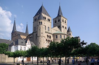
The High Cathedral of Saint Peter in Trier, or Trier Cathedral, is a Roman Catholic cathedral in Trier, Rhineland-Palatinate, Germany. It is the oldest church in Germany and the largest religious structure in Trier, notable for its long life span and grand design. The central part of the nave was built of Roman brick in the early fourth century, resulting in a cathedral that was added onto gradually in different eras. The imposing Romanesque westwork, with four towers and an additional apse, has been copied repeatedly. The Trier Cathedral Treasury contains an important collection of Christian art. In 1986 the church was listed as a UNESCO World Heritage Site, as part of the Roman Monuments, Cathedral of St. Peter and Church of Our Lady in Trier.

Trier in Rhineland-Palatinate, whose history dates to the Roman Empire, is often claimed to be the oldest city in Germany. Traditionally it was known in English by its French name of Treves.
The Roman Catholic diocese of Trier, in English traditionally known by its French name of Treves, is a diocese of the Latin Rite of the Roman Catholic church in Germany. When it was the archbishopric and Electorate of Trier, it was one of the most important states of the Holy Roman Empire, both as an ecclesiastical principality and as a diocese of the Church. Unlike the other Rhenish dioceses — Mainz and Cologne, Trier was the former Roman provincial capital of Augusta Treverorum. Given its status, Trier has always been the seat of a bishop since Roman times, one of the oldest dioceses in all of Germany. The diocese was elevated to an archdiocese in the time of Charlemagne and was the metropolitan for the dioceses of Metz, Toul, and Verdun. After the victory of Napoleon Bonaparte of France, the archdiocese was lowered to a diocese and is now a suffragan of the Archdiocese of Cologne. The diocesan cathedral is the Cathedral of Saint Peter. The Cathedral Chapter retains the right to elect the bishop, rather than selection by papal appointment.
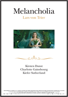
Melancholia is a 2011 science fiction drama art film written and directed by Lars von Trier and starring Kirsten Dunst, Charlotte Gainsbourg, and Kiefer Sutherland, with Alexander Skarsgård, Brady Corbet, Cameron Spurr, Charlotte Rampling, Jesper Christensen, John Hurt, Stellan Skarsgård, and Udo Kier in supporting roles. The film's story revolves around two sisters, one of whom is preparing to marry just before a rogue planet is about to collide with Earth.
Thomm Jutz is a German-born American singer, songwriter, producer and guitarist based in Nashville, Tennessee.

Corinna Rüffer is a German politician of Alliance 90/The Greens who has been serving as a member of the Bundestag from the state of Rhineland-Palatinate since 2013.

Anderson is a studio album by American singer-songwriter Bill Anderson. It was released on September 14, 2018 via TWI Records. The project was co-produced by Anderson, Peter Cooper and Thomm Jutz. Consisting of 11 tracks, the album was Anderson's 44th studio release in recording career. It contained one single that was released following the album. It is Anderson's most recent album to date.

Verena Ute Hubertz is a German entrepreneur and politician of the Social Democratic Party (SPD) who has been serving as a member of the Bundestag from the state of Rhineland-Palatinate since 2021.


