Sabinas River

Last updated
Sabinas River
Location
Country Mexico
Physical characteristics
Mouth  
 - location
Rio Salado
Official nameRío Sabinas
Designated2 February 2008
Reference no.1769 [1]
The Sabinas is a flowing river, a rarity in the Chihuahua Desert. El rio de san juan de sabinas, municipio de nueva rosita.jpg
The Sabinas is a flowing river, a rarity in the Chihuahua Desert.

The SabinasRiver is a river of Mexico. It is a tributary of the Rio Salado, which in turn flows into the Rio Grande.

Mexico country in the southern portion of North America

Mexico, officially the United Mexican States, is a country in the southern portion of North America. It is bordered to the north by the United States; to the south and west by the Pacific Ocean; to the southeast by Guatemala, Belize, and the Caribbean Sea; and to the east by the Gulf of Mexico. Covering almost 2,000,000 square kilometres (770,000 sq mi), the nation is the fifth largest country in the Americas by total area and the 13th largest independent state in the world. With an estimated population of over 120 million people, the country is the eleventh most populous state and the most populous Spanish-speaking state in the world, while being the second most populous nation in Latin America after Brazil. Mexico is a federation comprising 31 states and Mexico City, a special federal entity that is also the capital city and its most populous city. Other metropolises in the state include Guadalajara, Monterrey, Puebla, Toluca, Tijuana and León.

Rio Salado (Mexico) river in northern Mexico

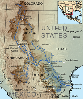
The Río Salado, also Río Salado de los Nadadores, or Salado River, is a river in northern Mexico, a tributary of the Rio Grande (Río Bravo). Its basin extends across the northern portion of Coahuila, Nuevo Leon, and Tamaulipas states.

Rio Grande river forming part of the US-Mexico border

The Rio Grande is one of the principal rivers in the southwest United States and northern Mexico. The Rio Grande begins in south-central Colorado in the United States and flows to the Gulf of Mexico. Along the way, it forms part of the Mexico–United States border. According to the International Boundary and Water Commission, its total length was 1,896 miles (3,051 km) in the late 1980s, though course shifts occasionally result in length changes. Depending on how it is measured, the Rio Grande is either the fourth- or fifth-longest river system in North America.

See also

Related Research Articles

Rio Conchos river in Mexico

The Río Conchos is a large river in the Mexican state of Chihuahua. It joins the Río Bravo del Norte at the town of Ojinaga, Chihuahua.

Rio Grande Wild and Scenic River

The Rio Grande Wild and Scenic River is a U.S. National Wild and Scenic River that protects 260 miles (420 km) of the Rio Grande in New Mexico and Texas. The designation was first applied in 1968 to a 55.7-mile (89.6 km) stretch of the river in New Mexico; an additional 191.2 miles (307.7 km) of the river in Texas was added in 1978, followed by another 12.5 miles (20.1 km) in New Mexico in 1994.

Rio Chama

The Rio Chama, a major tributary river of the Rio Grande, is located in the U.S. states of Colorado and New Mexico. The river is about 130 miles (210 km) long altogether. From its source to El Vado Dam its length is about 50 miles (80 km), from El Vado Dam to Abiquiu Dam is about 51 miles (82 km), and from Abiquiu Dam to its confluence with the Rio Grande is about 34 miles (55 km).

San Juan River (Tamaulipas)

The San Juan River is the largest and most important river in the Mexican state of Nuevo León. The river feeds the El Cuchillo Dam, which provides the city of Monterrey with water. The San Juan River basin has a total surface area of 33,538 square kilometres (12,949 sq mi). The San Juan River is a tributary to the Rio Grande — which is the fourth largest river basin in North America. It begins in Coahuila, flows through Nuevo León and into Tamaulipas, where it finally joins the Rio Grande near Camargo, Tamaulipas.

Rio Puerco (Rio Grande tributary) river in the United States of America

The Rio Puerco is a tributary of the Rio Grande in the U.S. state of New Mexico. From its source on the west side of the Nacimiento Mountains, it flows about 230 miles (370 km), generally south to join the Rio Grande about 20 miles (32 km) south of Belen and about 50 miles (80 km) south of Albuquerque. Its drainage basin is about 7,350 square miles (19,000 km2) large, of which probably about 1,130 square miles (2,900 km2) are noncontributing.

The Balleza River, or Río Balleza, is a river of Mexico. It is a tributary of the Rio Conchos, which in turn flows into the Rio Grande.

The Candela River is a river of Mexico. It is a tributary of the Rio Salado, which in turn flows into the Rio Grande.

The Chuviscar River, is a river of Mexico. It is a tributary of the Rio Conchos, which in turn flows into the Rio Grande.

The San Pedro River (Chihuahua) is a river of Mexico. It is a tributary of the Rio Conchos, which in turn flows into the Rio Grande.

The Sabinas Hidalgo River is a river of Mexico. It is a tributary of the Rio Salado, which in turn flows into the Rio Grande.

Río Verde is a river in Jalisco, Mexico. It is a tributary of the Rio Grande de Santiago.

The Pesquería River, is a river of Mexico. It is a tributary of the San Juan River, which in turn flows into the Rio Grande.

The Parral River, is a river of Mexico. It is a tributary of the Rio Florido, which flows into the Rio Conchos, which in turn flows into the Rio Grande.

Florido River

Florido River is a river of Mexico. It is a tributary of the Rio Conchos, which in turn flows into the Rio Grande.

The Río Álamo, is a stream in the state of Tamaulipas, Mexico, and is a tributary of the Rio Grande. It is impounded by Las Blancas Dam, which was completed in 2001 and diverts water to the Marte Gómez Reservoir on the Rio San Juan, another tributary of the Rio Grande.

Jemez River river in the United States of America

The Jemez River is a tributary of the Rio Grande in the U.S. state of New Mexico. The river is formed by the confluence of the East Fork Jemez River and San Antonio Creek, which drain a number of tributaries in the area of the Jemez Mountains and Santa Fe National Forest. The Jemez River is about 50 miles (80 km) long, or about 80 miles (130 km) long if its longest headwater tributary, San Antonio Creek, is included. The East Fork Jemez River is about 22 miles (35 km) long. Both San Antonio Creek and the East Fork Jemez River flow through intricate meanders along their courses. The East Fork Jemez is a National Wild and Scenic River.

References

  1. "Río Sabinas". Ramsar Sites Information Service. Retrieved 25 April 2018.