A saddle is a supportive structure for a rider or other load, fastened to an animal's back by a girth.
Contents
Look up saddle in Wiktionary, the free dictionary.
Saddle may also refer to:
A saddle is a supportive structure for a rider or other load, fastened to an animal's back by a girth.
Saddle may also refer to:

Trail riding is riding outdoors on trails, bridle paths, and forest roads, but not on roads regularly used by motorised traffic. A trail ride can be of any length, including a long distance, multi-day trip. It originated with horse riding, and in North America, the equestrian form is usually called "trail riding," or, less often "hacking." In the UK and Europe, the practice is usually called horse or pony trekking.

Montrose County is a county located in the U.S. state of Colorado. As of the 2020 census, the population was 42,679. The county seat is Montrose, for which the county is named.

Larimer County is a county located in the U.S. state of Colorado. As of the 2020 census, the population was 359,066. The county seat and most populous city is Fort Collins. The county was named for William Larimer, Jr., the founder of Denver.

Jackson County is a county located in the U.S. state of Colorado. As of the 2020 census, the population was 1,379, and it was the fourth least populated in the state. The county is named after the United States President Andrew Jackson. The county seat and only municipality in the county is Walden.

Grand County is a county located in the U.S. state of Colorado. As of the 2020 census, the population was 15,717. The county seat is Hot Sulphur Springs.
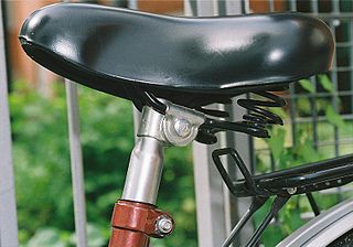
A bicycle seatpost, seatpin, saddlepole, saddle pillar, or saddle pin is a tube that extends upwards from the bicycle frame to the saddle. The amount that it extends out of the frame can usually be adjusted, and there is usually a mark that indicates the minimum insertion. Seatposts can be made of steel, aluminum, titanium, carbon fiber, or aluminum wrapped in carbon fiber.
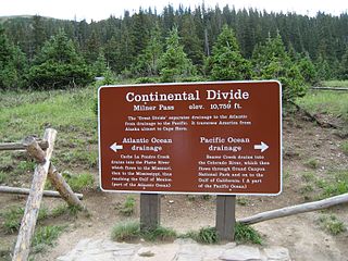
Milner Pass, elevation 10,759 ft (3,279 m) is a mountain pass in the Rocky Mountains of northern Colorado in the United States. It is located on the continental divide in the Front Range, within Rocky Mountain National Park, along the boundary between Larimer and Grand counties. The pass provides the passage over the continental divide for US 34, also known as Trail Ridge Road between Estes Park and Grand Lake. The pass is not, however, the high point on Trail Ridge Road, which crests at 12,183 ft (3,713 m) east of the pass within Rocky Mountain National Park. Along with the rest of Trail Ridge Road, the pass is generally closed in winter from the first heavy snow fall until the opening of the road around Memorial Day. The gentle pass divides the headwaters of the Cache la Poudre River and several creeks near the headwaters of the Colorado River to the west. The road near the pass provides a panoramic view of the Never Summer Mountains to the west.
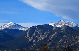
The Mummy Range is a mountain range in the Rocky Mountains of northern Colorado in the United States. The range is a short subrange of the Front Range located in southwestern Larimer County northwest of the town of Estes Park. It is located largely within Rocky Mountain National Park, extending north from Trail Ridge Road approximately 15 mi (24 km). The Arapaho name is "nooku-bee3ei-no," which translates to "White Owls."

Mount Sneffels is the highest summit of the Sneffels Range in the Rocky Mountains of North America. The 14,153-foot (4313.93 m) fourteener is located in the Mount Sneffels Wilderness of Uncompahgre National Forest, 6.7 miles (10.8 km) west by south of the City of Ouray in Ouray County, Colorado, United States. The summit of Mount Sneffels is the highest point in Ouray County.

The Fall River Pass Ranger Station in Rocky Mountain National Park was designed by National Park Service landscape architect Daniel Ray Hull in the National Park Service Rustic style. Built in 1922, the stone structure is similar in design to the Chasm Lake Shelter. Between 1933 and 1937 the ranger station was converted to a museum. The ranger station is associated with the construction of the nearby Trail Ridge Road. Located above the tree line, the building has a trap door in the roof to allow access when the door is blocked by drifting snow.
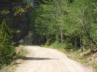
The Old Fall River Road, sometimes referred to as "The Old Road" by park staff in Rocky Mountain National Park, was the first automobile road to penetrate the interior of the park. The road linked the east side of the park near Estes Park with Grand Lake on the west side. Work began in 1913 but was interrupted in 1914 by World War I with final work being completed between 1918 and 1920.
Red Mountain Pass may be one of the following:

Cannibal Plateau is a summit in Hinsdale County, Colorado, in the United States. The broad 12,533-foot (3,820 m) mountain is located in the San Juan Mountains and within the Powderhorn Wilderness, a protected area managed by the Bureau of Land Management Gunnison Field Office and the Gunnison National Forest.

The 1964 United States presidential election in Colorado took place on November 3, 1964, as part of the 1964 United States presidential election. State voters chose six representatives, or electors, to the Electoral College, who voted for president and vice president.

The 1940 United States presidential election in Colorado took place on November 5, 1940, as part of the 1940 United States presidential election. State voters chose six representatives, or electors, to the Electoral College, who voted for president and vice president.
