Related Research Articles

The Thar Desert, also known as the Great Indian Desert, is an arid region in the north-western part of the Indian subcontinent that covers an area of 200,000 km2 (77,000 sq mi) in India and Pakistan. It is the world's 18th-largest desert, and the world's 9th-largest hot subtropical desert.

Marwar is a region of western Rajasthan state in North Western India. It lies partly in the Thar Desert. The word 'maru' is Sanskrit for desert. In Rajasthani languages, "wad" means a particular area. English translation of the word 'marwar' is 'the region of desert.'
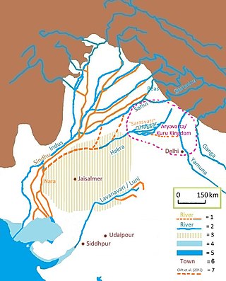
The Luni is the largest river in the Thar Desert of northwest India. It originates in the Pushkar valley of the Aravalli Range, near Ajmer, passes through the southeastern portion of the Thar Desert, and ends in the marshy lands of Rann of Kutch in Gujarat, after travelling a distance of 495 km (308 mi). It is first known as Sagarmati, then after passing Govindgarh, it meets its tributary Sarasvati, which originates from Pushkar Lake and from then on it is called Luni.
Gorwar or Godwar, is a region of Rajasthan state in India, which lies in the southwest Rajasthan and borders with the state of Gujarat.

Barmer District is a district in Rajasthan state of India. It is located in the western part of Rajasthan state forming a part of the Thar Desert. Barmer is the third largest district by area in Rajasthan and fifth largest district in India. Occupying an area of 28,387 km2. Being in the western part of the state, it includes a part of the Thar Desert. Jaisalmer is to the north of this district while Jalore is in its south. Pali and Jodhpur form its eastern border and it shares a border with Pakistan in the west. Partially being a desert, this district has a large variation in temperature. The temperature in summer can rise up to 51 °C and falls near to 0 °C in winter. Luni is the longest river in Barmer district. After travelling a length of almost 500 km, it passes through Jalore and merges in the marshy land of Runn of Kutch. District headquarters is in the town of Barmer. The other major towns in the district are: Balotra, Guda Malani, Baytoo, Siwana, and Chohatan. Recently, a large onshore oil field has been discovered and made functional in Barmer district. Now Barmer is also famous for Pomegrante. A village near Balotra name, Budiwada is named by Anar village. For reference check map of budiwada..It is a place of mystery.

Pali district is a district in Rajasthan, India. The city of Pali is its administrative headquarters.

Jodhpur District is a district in the State of Rajasthan in western India. The city of Jodhpur is the administrative headquarters of the district.
Jalore District is a district of Rajasthan state in western India. The city of Jalore is the administrative headquarters of the district. The district has an area of 10,640 km2 (4,108 sq mi), and a population of 1,828,730, with a population density of 136 persons per square kilometre.
Sukri river flows from the western slopes of Aravalli Range near Desuri in Pali district and flows through Guda Endla, Rani and Chanod. Its total length in the Pali district is 103 km. Another river of the same name originates from Aravali range and flows through Sojat and Gaguda, with total length of 75 km in Pali District. It feeds Bankli Dam, located in Jalore District and then merge with the Luni river near Samdari.

The Indira Gandhi Canal is the longest canal in India. It starts at the Harike Barrage near Harike, a few kilometers downriver from the confluence of the Satluj and Beas rivers in Punjab state, and ends in irrigation facilities in the Thar Desert in the northwest of Rajasthan state. Previously known as the Rajasthan Canal, it was renamed the Indira Gandhi Canal on 2 November 1984 following the assassination of Prime Minister Indira Gandhi.

Jawai Bandh is a dam built across the Jawai River, a tributary of Luni River, in Rajasthan.
Jaswantpura is a tehsil in the Jalore district of Rajasthan, India. It is the headquarters of Panchayat Samiti (block) and a part of the Jaswantpura subdivision; before 1947, it was the headquarters of the Pargana. The village was declared a tehsil in the Rajasthan budget 2012–13, and is named after the ruler of Marwar, Jodhpur: Maharaja Jaswant Singh.
Mithari is a river in Pali district originates from confluence of many small nallahs from south-western slopes of Aravalli Range in Pali district. It vanishes in Jalore district near Sankhwali village. Bali and Falna comes in its basin. Its catchment area is about 1,644 km2, in Pali and Jalore districts.

The Bandi River, also known as the Hemawas River, is a significant river in the Pali District of Rajasthan, India. It is formed by the confluence of the Khari and Mithari Rivers near the Bombadra pickup weir. The river flows for approximately 45 km before merging with the Luni River near the village of Lakhar.
The origin of Jawai river is in the hills of Goriya village of Bali town, located on the border of Pali and Udaipur districts.
Gudamalani is a town and Tehsil within the Barmer district of Rajasthan state of India. The village is located in the Thar desert. Gudamalani is situated on the highway connecting Jodhpur to Ahmedabad. This area unlike the Thar desert area is somewhat green and the land is fertile. The Luni River of Rajasthan flows through Gudamalani. This town in near several historical temples, such as Aalam ji's temple, Bhuteswar temple, Guru Jambheswer Bhagwan temple with Darmshala, and Bholaghar ji temple.

The Narmada Canal is a contour canal in Western India that brings water from the Sardar Sarovar Dam to the state of Gujarat and then into Rajasthan state. The main canal has a length of 532 kilometres (331 mi). It is the second longest canal in India and the largest canal by water carrying capacity. The main canal is connected with 42 branch canals providing irrigation to 2,129,000 hectares farmland. The canal is designed to transfer 9.5 million acre-feet water annually from the Narmada Basin to areas under other river basins in Gujarat and Rajasthan..
The following outline is provided as an overview of and topical guide to Rajasthan:
Umarlai Khalsa is a village in Barmer District of Rajasthan state in India. It is about 100 km from Jodhpur. The town is famous for farming, Mata Nagnechiyaa Temple and Akhada, The town is well connected with Jodhpur by buses at frequent intervals. From Umarlai Khalsa towards Jalore there is India's Third Brahma Temple in the village of Asotra. From Umarlai Khalsa towards Barmer there is Ancient Temple of Lord Shri Vishnu named as Shri Ranchore Ray, Khed Mandir in the village of Khed The name Umarlai Khalsa derived from all the religious people of this village. About 13 km from Balotra is located the famous Jain Temple Nakoda. The place receives religious devotees from across India. The town is located near on the coast of the river Luni. The village of Umarlai Khalsa is mainly popular for housing the famous Ancient Temples of Lord Shiva. It is one of the most revered pilgrimage destinations for the Hindu community. The temple is an excellent example of fine architecture and many sculptures are carved inside the temple. Apart from this temple, a number of other temples are located in the town which include the Pabuji Rathord Mandir, Jog Maya Matha Mandir, Gogaji Mandir, Bhomiyaji Mandir, Hanuman Mandir and more.
The Khari River is a river in the Sirohi and Jalore districts of Rajasthan, India. It is formed by the meeting of many small river drains from the hills of Shergaon in Sirohi district. The main ones are Somesar River, Khari Kherwa, Umravas Nala and Kotki River originating from Divar Forest Reserve.
References
- ↑ "Sagi River in India". www.india9.com. Retrieved 2023-08-10.
- 1 2 3 4 Jain, Sharad K.; Agarwal, Pushpendra K.; Singh, Vijay P. (2007-05-16). Hydrology and Water Resources of India. Springer Science & Business Media. p. 748. ISBN 978-1-4020-5180-7.
- ↑ Dhabriya, S. S. (1988). Desert Spread and Desertification: An Analysis of the Identified Aravalli Gaps on the Desert Fringe. Environmentalist. p. 3.
- 1 2 Rajasthan (India) (1962). Rajasthan [district Gazetteers].: Ajmer. Printed at Government Central Press. p. 5.